IMAGES TAKEN NEAR TO
Draper Road, BOURNEMOUTH, BH11 8BD
Introduction
This page details the photographs taken nearby to Draper Road, BH11 8BD by members of the Geograph project.
The Geograph project started in 2005 with the aim of publishing, organising and preserving representative images for every square kilometre of Great Britain, Ireland and the Isle of Man.

There are currently over 7.5m images from over14,400 individuals and you can help contribute to the project by visiting https://www.geograph.org.uk
Image Map (75 Images)


Leaflet Map data © OpenStreetMap
Images are licensed for reuse under creativecommons.org/licenses/by-sa/2.0
Notes
- Clicking on the map will re-center to the selected point.
- The higher the marker number, the further away the image location is from the centre of the postcode.
Image Listing (75 Images Found)
Images are licensed for reuse under creativecommons.org/licenses/by-sa/2.0
Image
Details
Distance
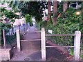
1
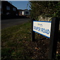
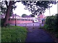
West Howe: Draper Road
Looking along Draper Road from its northern end, on Moore Avenue. It is in the heart of the large West Howe 1950s council estate - one half of a typical council semi is in the background along with a more modern bungalow.
The sign is a modern one, from 2010-15 when this more modern, abstract emblem rather than the traditional town coat of arms as the working logo of the council.
This is photo no.114 of a series of 453 in my coronavirus lockdown walking project:
See https://www.geograph.org.uk/article/My-2020-Coronavirus-Lockdown-walking-project for the complete set of photos.
Image: © Chris Downer
Taken: 11 Apr 2020
0.04 miles
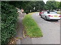
2

West Howe: April Close
The parked car made a good-perspective photograph difficult, but it can be seen in the background that April Close turns to the left, more or less parallel with the main Poole Lane where we stand. The houses take a direct line from one road to the other, and it is my strong suspicion that April Close is in fact the original line of Poole Lane. Historical maps suggest that the current line of Poole Lane has been extant since the 1940s.
This is photo no.13 of a series of 451 in my coronavirus lockdown walking project:
See https://www.geograph.org.uk/article/My-2020-Coronavirus-Lockdown-walking-project for the complete set of photos.
Image: © Chris Downer
Taken: 18 Apr 2020
0.04 miles
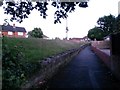
3
West Howe: footpath U28 diverges from Moore Avenue
Looking along Moore Avenue as it approaches Poole Lane (distance). The pedestrian who wishes to turn left at the bottom can cut the corner off via this public footpath which takes a much more direct route. See Image for a view up the path towards us, and links to further pictures on the way down.
Image: © Chris Downer
Taken: 30 Jun 2016
0.06 miles
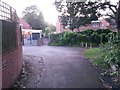
4
West Howe: footpath U28 heads for Moore Avenue
This public footpath ascends to meet Moore Avenue almost parallel with it - it runs just to our left, at the top of the grass bank. See Image
See Image] for a view down onto the path behind us from the top of the grass bank to the left.
Image: © Chris Downer
Taken: 28 Jun 2016
0.06 miles
5
West Howe: footpath U28 passes April Close
Looking along this public footpath, which provides a cut-through from Moore Avenue behind us to Poole Lane, through the narrow path ahead. Between the two segments is the dead end of April Close, which heads left in the centre of the picture.
See Image] for the next view along the alley ahead, and Image] for the view down onto the path from the top of the grass bank to our right.
Meanwhile on the right is a further public footpath - see Image
Image: © Chris Downer
Taken: 28 Jun 2016
0.06 miles
6
West Howe: footpath U29 reaches April Close
Looking along the western end of this public footpath from the bottom of Moore Avenue, which is just out of picture above the grass bank on the left. It faces the dead end of April Close and a further footpath is available left or right - see Image
See Image for the view towards us from the road ahead, and Image for the view down to here from the top of the grass bank to our left.
Image: © Chris Downer
Taken: 28 Jun 2016
0.06 miles
7
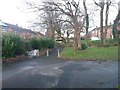
West Howe: footpaths meet at the dead end of April Close
Looking across the dead end of this minor cul-de-sac. Opposite, public footpath U29 heads along to Moore Avenue near its western end, while another public footpath, number U28, heads left (onto Poole Lane) and right, coming out further along Moore Avenue. Moore Avenue is the road seen in the background, at the far edge of the grass slope.
See Image for the view towards us on path U29 ahead, and Image for the view right-to-left on path U28. Each has links to further photos on the paths.
Image: © Chris Downer
Taken: 6 Mar 2017
0.06 miles
8
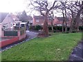
West Howe: looking down onto footpath U28
We stand on the pavement of Moore Avenue and look down the grassy slope onto the public footpath cutting the corner off. The path passes the dead end of April Close (opposite the abandoned shopping trolley) and continues through the alley onto Poole Lane.
See Image for the view on the path, upward to our left, and Image for the view across the end of April Close.
Another footpath, number N29, heads right from alongside the shopping trolley: see Image
Image: © Chris Downer
Taken: 6 Mar 2017
0.07 miles
9
West Howe: footpath U28 comes out on Poole Lane
This public footpath, essentially a corner-cutting route from Moore Avenue, emerges onto Poole Lane opposite the Holloway Avenue turning.
See Image for the view towards us from the pavement ahead, and Image for the next view behind us.
Image: © Chris Downer
Taken: 6 Mar 2017
0.07 miles
10
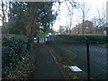
West Howe: this segment of footpath U28 is called Osprey Lane
Many of the footpaths on the West Howe estate and thereabouts have been given names in the last couple of years, a safety initiative whose intention is that, in the event of calling for help, one's location can be more easily described. This one is named Osprey Lane because the neighbouring houses, on the left, are built on the site of the Osprey pub which was demolished in the mid-1990s.
See Image for the view towards us from midway along the alley, with links to further photos on the path.
Image: © Chris Downer
Taken: 28 Jun 2016
0.07 miles