IMAGES TAKEN NEAR TO
Endfield Road, BOURNEMOUTH, BH9 1TJ
Introduction
This page details the photographs taken nearby to Endfield Road, BH9 1TJ by members of the Geograph project.
The Geograph project started in 2005 with the aim of publishing, organising and preserving representative images for every square kilometre of Great Britain, Ireland and the Isle of Man.

There are currently over 7.5m images from over14,400 individuals and you can help contribute to the project by visiting https://www.geograph.org.uk
Image Map
Images are licensed for reuse under creativecommons.org/licenses/by-sa/2.0
Notes
- Clicking on the map will re-center to the selected point.
- The higher the marker number, the further away the image location is from the centre of the postcode.
Image Listing (81 Images Found)
Images are licensed for reuse under creativecommons.org/licenses/by-sa/2.0
Image
Details
Distance
1
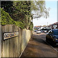
Moordown: King Edward Avenue
One of three consecutive monarchical avenues in Moordown, King George and Queen Mary Avenues being parallel to the south. They comprise typical Moordown housing - decent detached houses from the reign of Edward and the Georges in the 20th century.
The sign is an old cast-iron one from the 1950s, not exactly a rarity but nice to see surviving, refixed to a more modern fence.
This is photo no.221 of a series of 453 in my coronavirus lockdown walking project:
See https://www.geograph.org.uk/article/My-2020-Coronavirus-Lockdown-walking-project for the complete set of photos.
Image: © Chris Downer
Taken: 12 Apr 2020
0.02 miles
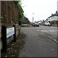
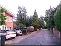
2
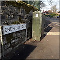
Moordown: Endfield Road
This looks as if it might be a misspelling of Enfield, but in fact it is at the end of the field – the field being Moordown Recreation Ground, which is the other side of the wall.
The sign looks like the standard Bournemouth nameplate from the 1980s, affixed with tubular steel which protrudes at each side, but actually the angle of the sun right now is perfect to show that it is in fact an older version, the lettering being embossed rather than adhesive.
This is photo no.132 of a series of 453 in my coronavirus lockdown walking project:
See https://www.geograph.org.uk/article/My-2020-Coronavirus-Lockdown-walking-project for the complete set of photos.
Image: © Chris Downer
Taken: 12 Apr 2020
0.04 miles
4
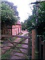
Moordown: thatched cottage in McWilliam Road
Only a glimpse of this thatched cottage, at Image], is available from the gateway. It is, to my knowledge, the only thatched cottage in the Moordown area, a rural looking enclave in the midst of much late 19th and early 20th century development, and much more recent stuff too.
Image: © Chris Downer
Taken: 22 Jun 2016
0.08 miles
5
Moordown: Mayfield Road
Mayfield Road comes towards the camera from Coronation Road and crosses the three 'royal' avenues – Queen Mary, King George and King Edward – before turning a slight bend to end on Malvern Road. That last segment, distant behind us, was called Clarkson Road until about the mid-1930s.
The sign is a modern one, from 2010-15 when this more modern, abstract emblem rather than the traditional town coat of arms as the working logo of the council.
This is photo no.265 of a series of 453 in my coronavirus lockdown walking project:
See https://www.geograph.org.uk/article/My-2020-Coronavirus-Lockdown-walking-project for the complete set of photos.
Image: © Chris Downer
Taken: 18 Apr 2020
0.08 miles
6
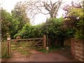
Moordown: the end of McWilliam Road
Image] comes to an abrupt end, at this gateway to what is, to my knowledge, the only thatched cottage in the whole Moordown area - see Image
Just to the right is a short path, public footpath M11, to Mayfield Road. See Image] for a view along the footpath.
Image: © Chris Downer
Taken: 22 Jun 2016
0.09 miles
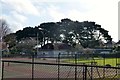
7
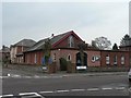
Moordown: Church of the Nazarene
A small church on the corner of Mayfield Road (ahead and behind) and Queen Mary Avenue (left and right). The 1975 Kelly's Directory lists it as the Andrew Vine Memorial Church of the Nazarene, but I can find no mention of Andrew Vine today.
Image: © Chris Downer
Taken: 24 Feb 2008
0.09 miles
8
Moordown: footpath M11 from the dead end of McWilliam Road
We have reached Image and here at right-angles is a short public footpath to Mayfield Road. See Image for the view of its emergence.
(The gateway to the left is to one of the oldest buildings in the area: Image).
Image: © Chris Downer
Taken: 26 Feb 2017
0.09 miles
9
Moordown: McWilliam Road
A funny little backwater of a road, not at all typical of the area. It contains literally only six or seven premises, ranging from the relatively modern house on the left to the thatched cottage (quite possibly the only one in Moordown) at the end (see Image).
Image: © Chris Downer
Taken: 22 Jun 2016
0.09 miles
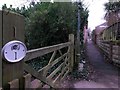
10
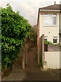
Moordown: footpath M11 to McWilliam Road
Looking along this short path, leading to Image from Mayfield Road.
This is an extension of the more substantial straight path (Image) behind us to Wimborne Road.
See Image for the view towards us from a little way along the path.
Image: © Chris Downer
Taken: 22 Jun 2016
0.10 miles