IMAGES TAKEN NEAR TO
Draper Road, BOURNEMOUTH, BH11 8BE
Introduction
This page details the photographs taken nearby to Draper Road, BH11 8BE by members of the Geograph project.
The Geograph project started in 2005 with the aim of publishing, organising and preserving representative images for every square kilometre of Great Britain, Ireland and the Isle of Man.

There are currently over 7.5m images from over14,400 individuals and you can help contribute to the project by visiting https://www.geograph.org.uk
Image Map
Images are licensed for reuse under creativecommons.org/licenses/by-sa/2.0
Notes
- Clicking on the map will re-center to the selected point.
- The higher the marker number, the further away the image location is from the centre of the postcode.
Image Listing (75 Images Found)
Images are licensed for reuse under creativecommons.org/licenses/by-sa/2.0
Image
Details
Distance
1
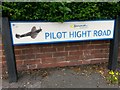
West Howe: Pilot Hight Road sign
The West Howe estate's roads are all surnames of servicemen from the Second World War with a local connection.
The only road to have a word before the surname is Pilot Hight Road. Pilot Officer Cecil Hight was a New Zealander who flew Spitfires in the RAF. Coming under fire in August 1940, his aircraft was hit in a major air raid over Bournemouth. It is thought that he diverted his plane to avoid the town centre and it crashed in the Meyrick Park area - he died as a result of parachute failure. (See Image)
The modern road sign here has an image of a spitfire - a nice touch.
Image: © Chris Downer
Taken: 30 Jun 2016
0.06 miles
2
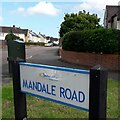
West Howe: Mandale Road
Mandale Road is one of the main roads within the West Howe council estate, and it has an unusual 90º bend here, running ahead and to our right, while to the left the road with vehicle priority continues as Draper Road.
The sign is a modern one, from 2010-15 when this more modern, abstract emblem rather than the traditional town coat of arms as the working logo of the council.
This is photo no.258 of a series of 453 in my coronavirus lockdown walking project:
See https://www.geograph.org.uk/article/My-2020-Coronavirus-Lockdown-walking-project for the complete set of photos.
Image: © Chris Downer
Taken: 18 Apr 2020
0.06 miles
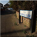
3

West Howe: April Close
The parked car made a good-perspective photograph difficult, but it can be seen in the background that April Close turns to the left, more or less parallel with the main Poole Lane where we stand. The houses take a direct line from one road to the other, and it is my strong suspicion that April Close is in fact the original line of Poole Lane. Historical maps suggest that the current line of Poole Lane has been extant since the 1940s.
This is photo no.13 of a series of 451 in my coronavirus lockdown walking project:
See https://www.geograph.org.uk/article/My-2020-Coronavirus-Lockdown-walking-project for the complete set of photos.
Image: © Chris Downer
Taken: 18 Apr 2020
0.08 miles
4
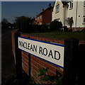
West Howe: Maclean Road
Typical 1950s semi-detached council houses are the fare around here, as we are near the centre of the large West Howe council estate, which was built in the early 50s.
The sign is a modern one, dating from around 2014-15, by which time the council had replaced the coloured logo, which had been prone to fading after a while, to simple wording BOURNEMOUTH BOROUGH COUNCIL in smaller type.
This is photo no.254 of a series of 453 in my coronavirus lockdown walking project:
See https://www.geograph.org.uk/article/My-2020-Coronavirus-Lockdown-walking-project for the complete set of photos.
Image: © Chris Downer
Taken: 11 Apr 2020
0.08 miles
5
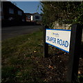
West Howe: Draper Road
Looking along Draper Road from its northern end, on Moore Avenue. It is in the heart of the large West Howe 1950s council estate - one half of a typical council semi is in the background along with a more modern bungalow.
The sign is a modern one, from 2010-15 when this more modern, abstract emblem rather than the traditional town coat of arms as the working logo of the council.
This is photo no.114 of a series of 453 in my coronavirus lockdown walking project:
See https://www.geograph.org.uk/article/My-2020-Coronavirus-Lockdown-walking-project for the complete set of photos.
Image: © Chris Downer
Taken: 11 Apr 2020
0.09 miles
6
West Howe: Mandale Close
In the heart of the 1950s West Howe council estate, the houses in this short cul-de-sac actually form an unbroken line into the similar Springwater Close, the two closes meeting end-to-end with a wide footpath providing a single thoroughfare.
The sign is a modern one, from 2010-15 when this more modern, abstract emblem rather than the traditional town coat of arms as the working logo of the council.
This is photo no.257 of a series of 453 in my coronavirus lockdown walking project:
See https://www.geograph.org.uk/article/My-2020-Coronavirus-Lockdown-walking-project for the complete set of photos.
Image: © Chris Downer
Taken: 11 Apr 2020
0.10 miles
7
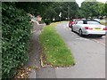
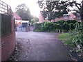
West Howe: footpath U28 diverges from Moore Avenue
Looking along Moore Avenue as it approaches Poole Lane (distance). The pedestrian who wishes to turn left at the bottom can cut the corner off via this public footpath which takes a much more direct route. See Image for a view up the path towards us, and links to further pictures on the way down.
Image: © Chris Downer
Taken: 30 Jun 2016
0.11 miles
8
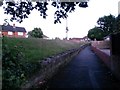
West Howe: footpath U28 heads for Moore Avenue
This public footpath ascends to meet Moore Avenue almost parallel with it - it runs just to our left, at the top of the grass bank. See Image
See Image] for a view down onto the path behind us from the top of the grass bank to the left.
Image: © Chris Downer
Taken: 28 Jun 2016
0.11 miles
9
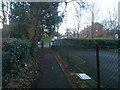
West Howe: footpath U28 comes out on Poole Lane
This public footpath, essentially a corner-cutting route from Moore Avenue, emerges onto Poole Lane opposite the Holloway Avenue turning.
See Image for the view towards us from the pavement ahead, and Image for the next view behind us.
Image: © Chris Downer
Taken: 6 Mar 2017
0.12 miles
10
West Howe: footpath U28 passes April Close
Looking along this public footpath, which provides a cut-through from Moore Avenue behind us to Poole Lane, through the narrow path ahead. Between the two segments is the dead end of April Close, which heads left in the centre of the picture.
See Image] for the next view along the alley ahead, and Image] for the view down onto the path from the top of the grass bank to our right.
Meanwhile on the right is a further public footpath - see Image
Image: © Chris Downer
Taken: 28 Jun 2016
0.12 miles