IMAGES TAKEN NEAR TO
The Paddocks, Parish Room Croft, TELFORD, TF6 6PP
Introduction
This page details the photographs taken nearby to The Paddocks, Parish Room Croft, TF6 6PP by members of the Geograph project.
The Geograph project started in 2005 with the aim of publishing, organising and preserving representative images for every square kilometre of Great Britain, Ireland and the Isle of Man.

There are currently over 7.5m images from over14,400 individuals and you can help contribute to the project by visiting https://www.geograph.org.uk
Image Map
Images are licensed for reuse under creativecommons.org/licenses/by-sa/2.0
Notes
- Clicking on the map will re-center to the selected point.
- The higher the marker number, the further away the image location is from the centre of the postcode.
Image Listing (16 Images Found)
Images are licensed for reuse under creativecommons.org/licenses/by-sa/2.0
Image
Details
Distance
1
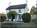
Fir Tree cottage, Waters Upton
An early 19th century, sandstone ashlar cottage, which was Grade II listed https://britishlistedbuildings.co.uk/101033312-fir-tree-waters-upton#.XBGBJ9SLTGg in 1983
Image: © Richard Law
Taken: 17 Nov 2018
0.07 miles
2
Waters Upton
A well looking by the sign post at Waters Upton.
Image: © A Holmes
Taken: 19 May 2007
0.08 miles
3
Crescent House, Waters Upton
Built around the core of an 18th century house, with improvements in the mid 19th century (one 18th century wing remains at the rear) and Grade II listed https://britishlistedbuildings.co.uk/101033315-crescent-house-waters-upton#.XBGB6tSLTGg in 1983.
Image: © Richard Law
Taken: 17 Nov 2018
0.08 miles
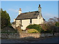
5
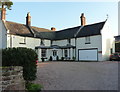
The White House, Waters Upton
The reason for the name is obvious enough. This is a late 18th century country house, with an additional 19th century wing added, which was Grade II listed https://britishlistedbuildings.co.uk/101033311-white-house-waters-upton#.XBF_tNSLTGg in 1983. The garage unit on the near end is much more modern, and probably exempt from the listing.
Image: © Richard Law
Taken: 17 Nov 2018
0.09 miles
6
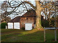
Former coach house at Waters Upton Hall
Putting aside the modern double garage to the left, the main building here with the pyramidal roof and hayloft, is the former coach house to the hall, which dates from the 18th century, and which was Grade II listed https://britishlistedbuildings.co.uk/101033313-coach-house-south-east-of-hall-waters-upton#.XBGGR9SLTGg in 1983.
Image: © Richard Law
Taken: 17 Nov 2018
0.10 miles
7
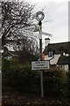
Old Direction Sign - Signpost in Waters Upton
Annulus finial - 4 arms; Shropshire CC modern halo by the UC road, in parish of Waters Upton (Telford and Wrekin District), Waters Upton junction with Catsbritch Lane.
Surveyed
Milestone Society National ID: SA_SJ6319
Image: © Milestone Society
Taken: Unknown
0.10 miles
9
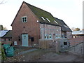
Barn NE of Waters Upton Hall
Now known as Crescent Farm Barn, and converted to residential use, this fine timber-framed barn dates from the late 16th or early 17th century, and was Grade II listed https://britishlistedbuildings.co.uk/101033314-barn-immediately-north-east-of-the-hall-waters-upton#.XBGHStSLTGg in 1983.
Image: © Richard Law
Taken: 17 Nov 2018
0.10 miles
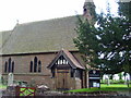
10
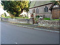
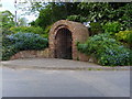
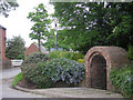
Churchyard boundary wall, Waters Upton
This sandstone retaining wall, including the squat gatepiers, for the raised churchyard was probably built in the late 18th or early 19th century, and was Grade II listed https://britishlistedbuildings.co.uk/101352004-churchyard-boundary-wall-north-of-church-of-st-michael-waters-upton#.XBGDxdSLTGg in 1983.
Image: © Richard Law
Taken: 17 Nov 2018
0.11 miles