IMAGES TAKEN NEAR TO
Pappert, ALEXANDRIA, G83 9LQ
Introduction
This page details the photographs taken nearby to Pappert, G83 9LQ by members of the Geograph project.
The Geograph project started in 2005 with the aim of publishing, organising and preserving representative images for every square kilometre of Great Britain, Ireland and the Isle of Man.

There are currently over 7.5m images from over14,400 individuals and you can help contribute to the project by visiting https://www.geograph.org.uk
Image Map
Images are licensed for reuse under creativecommons.org/licenses/by-sa/2.0
Notes
- Clicking on the map will re-center to the selected point.
- The higher the marker number, the further away the image location is from the centre of the postcode.
Image Listing (36 Images Found)
Images are licensed for reuse under creativecommons.org/licenses/by-sa/2.0
Image
Details
Distance
1
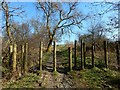
Woodland path
Ahead, and just visible to the right of the path, is a marker, shown in Image The community woodland contains paths for walkers (not motor bikes and similar vehicles that would quickly turn the paths into a muddy mess). The path shown here runs along the southern side of the Pappert Burn.
Image: © Lairich Rig
Taken: 24 Feb 2014
0.10 miles
2
Pappert Well Community Woodlands
This area of woodland, established in 2000, contains over 2 miles of footpaths. The marker visible in this photo stands not far south of a stream; compare some similar markers that are located at the start of a footpath on the other side of the stream: Image
Image: © Lairich Rig
Taken: 26 Dec 2008
0.10 miles
3
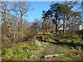
Woodland path
To the left (north) of the path, the ground slopes down steeply to the course of the Pappert Burn. On the right are the houses in Pappert. Further uphill, at the top of the housing estate, the path emerges into the open: Image / Image
There is another path running parallel to this one on the other side of the burn: Image The intervening glen of the burn would make it difficult to cross from one path to another at this point, and the other path is best joined either at its downhill end (Image), or much further uphill (near a Image), where the course of the burn is very shallow.
Image: © Lairich Rig
Taken: 24 Feb 2014
0.11 miles
4
Pappert Well Community Woodland
The community woodland was established in 2000. For more information, and for an earlier view in a different season, see Image
The trees on the left are at the top of a slope leading down to the Pappert Burn.
Image: © Lairich Rig
Taken: 24 Feb 2014
0.11 miles
5
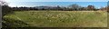
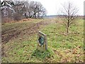
Woodland clearing
This particular clearing is depicted on the 1:25000 OS map. It is in Pappert Well Community Woodland.
The hills that can be seen left of centre in the background are Carman Hill (Image) and adjacent muirs.
Image: © Lairich Rig
Taken: 24 Feb 2014
0.11 miles
6
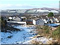
Pappert Well Community Woodland
The gate shown in this photograph is located at one of the three main entry points to Pappert Well Community Woodlands; see also Image
The nearer houses beyond the gate are in the Braehead area, while the more distant background houses are in other parts of the Vale of Leven. On the skyline, in the right-hand side of the image, are Carman Hill (Image) and the muirs that lie to its north.
Image: © Lairich Rig
Taken: 6 Feb 2009
0.13 miles
7
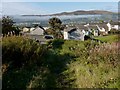
Path leading down towards Braehead
Two different paths lead downhill from the point that is shown in Image; the last part of the more northerly of the two paths is shown here.
Both paths lead to this area, at the top of Braehead, where one of the access points of the community woodland is located (as indicated by some markers: Image).
See Image for the same view in winter, and for background details.
Image: © Lairich Rig
Taken: 8 Oct 2012
0.13 miles
8
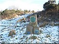
Pappert Well Community Woodlands - markers
There are three main entry points to this area of community woodland, with a marker, or markers, at each one.
The back of the tallest of these three markers can just be made out, silhouetted against the snow, in the following image: Image (in that image, the markers are located in front of the wooden posts that are to the left of the gate).
For the markers at the other two locations, see Image and Image
Image: © Lairich Rig
Taken: 6 Feb 2009
0.13 miles
9
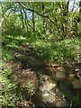
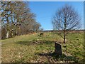
Surface of former drove road
The picture was taken from about the same spot as Image, but the present view is in the opposite direction (uphill). A burn flows along this part of the route, and at this point it allows a view beneath the vegetation cover: the surface rather resembles crude paving slabs. Whether they date from the period when this was a drove road, or from recent times, I cannot say.
Image: © Lairich Rig
Taken: 22 May 2016
0.13 miles
10

Line of old drove road
This is a view downhill. To the right (north) are a wall and a fence that form the boundary of an adjacent field. To the left is a mound that is an old wall, mostly overgrown with turf. Just beyond it is the present-day path (Image), which is next to a slope leading down to the Pappert Burn.
The present picture is a view along what I take to be the line of the old drove road here. The nearby present-day path closely follows the upper edge of the slope leading down to the Murroch Burn, while the older drove road instead consistently follows the edge of the wall that forms the field boundary. For much of its length (specifically, where the burn is not far from the field boundary), the present-day path follows the same line as the old drove road: see Image for an example.
Where the burn meanders farther from the field boundary, the current path and the old drove route diverge, as at the point shown here.
A view uphill from the same spot included an area that a burn flows through, exposing some stones to view; I found it tempting to see these as a form of paving, though I cannot tell whether they date from the days of droving, or from more recently: Image
Image: © Lairich Rig
Taken: 22 May 2016
0.13 miles