IMAGES TAKEN NEAR TO
Hawthorn Way, DUMBARTON, G82 5EB
Introduction
This page details the photographs taken nearby to Hawthorn Way, G82 5EB by members of the Geograph project.
The Geograph project started in 2005 with the aim of publishing, organising and preserving representative images for every square kilometre of Great Britain, Ireland and the Isle of Man.

There are currently over 7.5m images from over14,400 individuals and you can help contribute to the project by visiting https://www.geograph.org.uk
Image Map
Images are licensed for reuse under creativecommons.org/licenses/by-sa/2.0
Notes
- Clicking on the map will re-center to the selected point.
- The higher the marker number, the further away the image location is from the centre of the postcode.
Image Listing (65 Images Found)
Images are licensed for reuse under creativecommons.org/licenses/by-sa/2.0
Image
Details
Distance
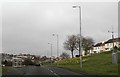
1
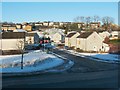
Hawthorn Avenue
Cardross Road runs across the image from left to right in the foreground. The road branching off from it is Hawthorn Avenue.
The elevated viewpoint for this photograph was the top of a slope in front of neighbouring Westcliff.
Image: © Lairich Rig
Taken: 24 Dec 2010
0.03 miles
2
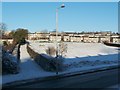
Path to Dalmoak
Cardross Road is visible in the foreground. On its far side, on the left, the route that is confined between two hedges is the first part of a path to Dalmoak.
That path is signposted (on the lamp post) as "Path to Dalmoak via Castlehill ¾ mile".
The former site of Hawthornhill Farm is visible in this picture: to the left of the lamp post, and to the right of the hedge-lined path, is a large drain cover; directly behind that is a green embankment with less snow cover than its surroundings. The buildings of Hawthornhill stood on the flat area at the top of that embankment, centred on Image: Image
Image: © Lairich Rig
Taken: 24 Dec 2010
0.05 miles
3
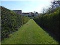
Path from Hawthornhill Road
This path was once a road leading from Hawthornhill Farm; the farm, now long gone, was at the other end, behind the photographer: Image Ahead, the path meets Cardross Road; see Image, a view back from the other side of that road. The houses in the background are in Westcliff.
Compare Image, similar to the present picture, but looking in the other direction along the path.
Image: © Lairich Rig
Taken: 9 Apr 2019
0.05 miles
4
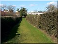
Path to Hawthornhill Road
This photograph is a view from the start of the path that can be seen, between two hedges, in Image In the present view, only the nearer part of the path (the first 30 metres or so) is in the same grid square as the photographer. This short path leads from Cardross Road to Hawthornhill Road, but it is part of a longer route, a core path, from Hawthornhill to Dalmoak.
This hedge-lined path was originally a track leading from Cardross Road to Hawthornhill Farm. The farm itself is long gone, but the buildings were just to the right of the far end of this path, on the top of the grassy slope that can be seen there; see Image for the site itself.
Ahead, just to the right of the far end of the path, is Image As that photo makes clear, there are a few narrow gaps between the buildings of Perray Avenue; these divide the row of houses into four sections.
Without familiarity with the area, it is not at all clear where to go after ascending this path between the two hedges. However, the easiest way to continue along the core path to Dalmoak is to go through the narrow gap between the first and second sections (reckoning from the leftmost/western end) of Perray Avenue, emerging at the point shown in Image
Image: © Lairich Rig
Taken: 24 Mar 2011
0.05 miles
5
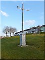
Automated weather station
The location is near a junction of Image (a road) and Cardross Road.
Image: © Lairich Rig
Taken: 18 Jan 2013
0.06 miles
7
Drain cover at Hawthornhill
For context, see Image and Image, in both of which the drain cover is visible. The houses in the background are in Westcliff. Behind the hedge on the right is a path (shown at the second of the links just given), formerly a road to the now gone Hawthornhill Farm: Image
Image: © Lairich Rig
Taken: 7 Jun 2020
0.07 miles
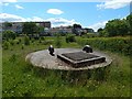
9
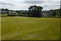
Grassland at Hawthornhill
The picture was taken from Image
Compare Image, a distant view in the opposite direction; the embankment can be seen here, as can a heavy drain cover that is visible on the left, on the near side of the hedge, in the present picture. Behind the hedge is a path (shown better in the picture just linked), which was once the road leading to Hawthornhill Farm from the main road (which followed the present-day line of Cardross Road).
The houses in the left background are at Westcliff. Those on the right are at Lennox Gardens (an area of housing where many of the streets have "Perrays" in their name; see https://www.geograph.org.uk/snippet/17333 for the significance of that).
Some play areas are out of shot to the left: see Image
Image: © Lairich Rig
Taken: 26 Jun 2013
0.10 miles
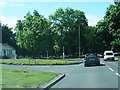
10
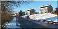
Hawthornhill Road
This is the western end of the road. Not far ahead, where a car is parked beside an evergreen tree, Image leads off to the right. The photograph was taken from the top of a path that is shown, between two hedges, in Image
This end of the road would fall within the area that is called Hawthornhill, but its other end is located in Castlehill. See Image and Image
The point from which the present photograph was taken is close to Image; that farm is shown on the first-edition OS map (surveyed in 1860); it was located at Image The name appears as "Haithorn Hill" on the Pont/Blaeu map of the Lennox (surveyed in the 1580s-90s, published in 1654).
On the Pont/Blaeu map, "Clerkhil" and "Heuack" are shown just to the south of "Haithorn Hill", and "Castelhill" and "Airdoch Beg" are just to the north. A convent ( http://www.geograph.org.uk/photo/2335961 ) later occupied the site of Clarkhill; Havoc was at the shore ( http://www.geograph.org.uk/photo/2411704 ), and its name is still associated with that area; Castlehill is the name of an area of Dumbarton ( http://www.geograph.org.uk/photo/2404694 ); and Ardochbeg is now a ruin ( http://www.geograph.org.uk/photo/927345 ).
In his "Old Cardross" (1880), David Murray discusses these farms, and gives an earlier name for Hawthornhill: "Turning south from Ardochbeg and below Whiteleys is Hawthornhill, or, as it used to be called, Latriehill [i.e., wet hill slope]. Beyond it, overlooking Clyde, is Clerkhill, and below the latter at the foot of the old raised beach is the Havock" (the bracketed comment on the meaning of Latriehill is the author's own remark, not mine).
See the comments on "leitir" at Image for more on the signification of that element in Gaelic place-names (it differs a little from Murray's interpretation). Such a derivation would at least be appropriate here, in that the land at what is now Hawthornhill slopes down towards the Clyde.
Image: © Lairich Rig
Taken: 24 Dec 2010
0.11 miles