Hawthornhill Road
Introduction
The photograph on this page of Hawthornhill Road by Lairich Rig as part of the Geograph project.
The Geograph project started in 2005 with the aim of publishing, organising and preserving representative images for every square kilometre of Great Britain, Ireland and the Isle of Man.

There are currently over 7.5m images from over 14,400 individuals and you can help contribute to the project by visiting https://www.geograph.org.uk
Hawthornhill Road
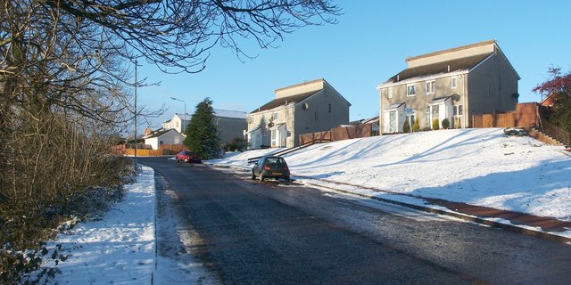
Image: © Lairich Rig Taken: 24 Dec 2010
This is the western end of the road. Not far ahead, where a car is parked beside an evergreen tree, Image leads off to the right. The photograph was taken from the top of a path that is shown, between two hedges, in Image This end of the road would fall within the area that is called Hawthornhill, but its other end is located in Castlehill. See Image and Image The point from which the present photograph was taken is close to Image; that farm is shown on the first-edition OS map (surveyed in 1860); it was located at Image The name appears as "Haithorn Hill" on the Pont/Blaeu map of the Lennox (surveyed in the 1580s-90s, published in 1654). On the Pont/Blaeu map, "Clerkhil" and "Heuack" are shown just to the south of "Haithorn Hill", and "Castelhill" and "Airdoch Beg" are just to the north. A convent ( http://www.geograph.org.uk/photo/2335961 ) later occupied the site of Clarkhill; Havoc was at the shore ( http://www.geograph.org.uk/photo/2411704 ), and its name is still associated with that area; Castlehill is the name of an area of Dumbarton ( http://www.geograph.org.uk/photo/2404694 ); and Ardochbeg is now a ruin ( http://www.geograph.org.uk/photo/927345 ). In his "Old Cardross" (1880), David Murray discusses these farms, and gives an earlier name for Hawthornhill: "Turning south from Ardochbeg and below Whiteleys is Hawthornhill, or, as it used to be called, Latriehill [i.e., wet hill slope]. Beyond it, overlooking Clyde, is Clerkhill, and below the latter at the foot of the old raised beach is the Havock" (the bracketed comment on the meaning of Latriehill is the author's own remark, not mine). See the comments on "leitir" at Image for more on the signification of that element in Gaelic place-names (it differs a little from Murray's interpretation). Such a derivation would at least be appropriate here, in that the land at what is now Hawthornhill slopes down towards the Clyde.
Images are licensed for reuse under creativecommons.org/licenses/by-sa/2.0
Image Location
Latitude
55.950848
Longitude
-4.602601