IMAGES TAKEN NEAR TO
Cornelius Avenue, NEWHAVEN, BN9 9TY
Introduction
This page details the photographs taken nearby to Cornelius Avenue, BN9 9TY by members of the Geograph project.
The Geograph project started in 2005 with the aim of publishing, organising and preserving representative images for every square kilometre of Great Britain, Ireland and the Isle of Man.

There are currently over 7.5m images from over14,400 individuals and you can help contribute to the project by visiting https://www.geograph.org.uk
Image Map
Images are licensed for reuse under creativecommons.org/licenses/by-sa/2.0
Notes
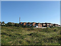
- Clicking on the map will re-center to the selected point.
- The higher the marker number, the further away the image location is from the centre of the postcode.
Image Listing (16 Images Found)
Images are licensed for reuse under creativecommons.org/licenses/by-sa/2.0
Image
Details
Distance
1
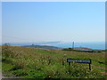
Harbour heights looking toward Seaford Head
The high ground between the town of Peacehaven and port of Newhaven contains gorse, scrubland, unmade roads, caravan parks and houses erected before the age of tough planning laws. This view was taken from the junction of Charleston Avenue and Pevensey Road. On the cliff top to the left is the coastguard lookout and radio mast, that to the right a small lighthouse. Beyond them is Seaford Bay, the far eastern end of Seaford and the clifftop of Seaford Head.
Image: © Simon Carey
Taken: 30 Aug 2005
0.07 miles
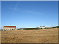
2
Field, Harbour Heights
Once sheep down this section is still used for agricultural purposes with the field running down to the cliff edge. The houses to the right are Westdean and Lyndale the only two hdwellings on Westdean Avenue.
Image: © Simon Carey
Taken: 31 Aug 2012
0.10 miles
3
Harbour Heights
The name given to the cliff top area within the parish of Newhaven. Much like neighbouring Peacehaven Heights the area was developed between the wars with roads laid out and a few plots purchased which, after the 1947 Planning Act, left the area with isolated houses and large open areas. The building to the left contains two houses; Lyndale and Westdean, whilst the white building to its right is Cliff Cottage. Newhaven heights caravan park lies in the lee of Castle Hill with Seaford and Seaford Head visible across Seaford Bay.
Image: © Simon Carey
Taken: 6 Jul 2012
0.11 miles
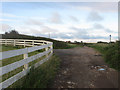
4
Pevensey Road, Harbour Heights
Unmade road that was laid out as part of the Harbour Heights development. The take up of plots was minimal and resulted in scattered dwellings along the roads that were laid out. The development was stopped in 1939 and never started after tougher planning laws were introduced in 1947. Four Winds is the house behind the tree to the left whilst the roof of Greenways is to the right.
Image: © Simon Carey
Taken: 31 Aug 2012
0.13 miles
5
Harbour Heights
The cliffs west of Newhaven were opened to development after the First World War with the plots sold individually for those wishing to build their own homes next to newly laid out roads. A mixture of cost, lack of connection to basic utilities and the depression of the late 1920s resulted in a scattered development which was halted by the onset of war and stopped completely by the advent of tougher planning laws in 1947. To the left are Westdean and Lyndale the only two dwellings on Westdean Avenue whilst to the right are four further dwellings based around Cuckmere Road and Charleston Avenue.
Image: © Simon Carey
Taken: 31 Aug 2012
0.13 miles
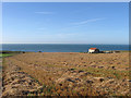
6
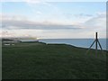
Bronze Age Barrow
The barrow was excavated in 2008 as it is expected to fall into the sea within the next 25 years. Archeologists discovered tools including a flint arrowhead from the mesolithic period which pointed to an occupation of the area prior to the construction of the barrow around 2000-3000 years ago. Other artifacts included pottery and clay pipes from the 18th and 19th century and evidence of a slit trench dug during World War Two most likely associated with the fence post to the right which is a remnant of Image and was used to mark out the compound the facility. In the distance to the left is Cliff Cottage whilst beyond it is Newhaven Heights Caravan Park. Across Seaford Bay the sun is shining on Seaford and Seaford Head.
Image: © Simon Carey
Taken: 6 Jul 2012
0.18 miles
7
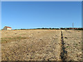
Footpath, Harbour Heights
Not a public one but well used by locals and marked out by the farmer. It links the cliff top at Old Nore Point to Pevensey Road and is one of a number that follow the edges of the field in the vicinity. To the left is Lyndale and Westdean the only houses on Westdean Avenue.
Image: © Simon Carey
Taken: 31 Aug 2012
0.19 miles
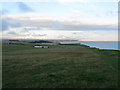
8
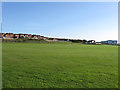
Playing Fields, Tideway School
This is the outer playing field lovely in summer, dreadful in winter with the gales blowing in off the sea. The main school building is to the right.
Image: © Simon Carey
Taken: 31 Aug 2012
0.19 miles
9
Recent Development, Harbour Heights
Built in the early part of the 00s over the unmade tracks of Pevensey Road, Pegler Avenue and Harbour View Road of which only the latter has survived within the development. Access to the estate is from Southdown Road.
Image: © Simon Carey
Taken: 31 Aug 2012
0.20 miles
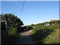
10
The Highway
An unmade road that provides access to the houses and caravan park on Rushy Hill. Now a restricted byway the road was the original road to Newhaven which was replaced by the current route of the A259 when that road was turnpiked in the early 19th century to lessen the gradient for coaches. The junction with Blakeney Avenue is to the left whilst the TV transmitter is visible in the distance.
Image: © Simon Carey
Taken: 6 Jul 2012
0.20 miles