IMAGES TAKEN NEAR TO
Collingwood Close, PEACEHAVEN, BN10 8BA
Introduction
This page details the photographs taken nearby to Collingwood Close, BN10 8BA by members of the Geograph project.
The Geograph project started in 2005 with the aim of publishing, organising and preserving representative images for every square kilometre of Great Britain, Ireland and the Isle of Man.

There are currently over 7.5m images from over14,400 individuals and you can help contribute to the project by visiting https://www.geograph.org.uk
Image Map
Images are licensed for reuse under creativecommons.org/licenses/by-sa/2.0
Notes
- Clicking on the map will re-center to the selected point.
- The higher the marker number, the further away the image location is from the centre of the postcode.
Image Listing (15 Images Found)
Images are licensed for reuse under creativecommons.org/licenses/by-sa/2.0
Image
Details
Distance
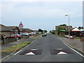
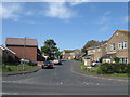
2
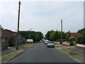
Glynn Road
One of the original east-west roads that ran from Phyllis Avenue to what was planned to be the northern extension of Steyning Avenue that for many years was little more than an unmade track. Most of the northern edge of Peacehaven was developed from the late 1970s onwards made up of cul-de-sacs rather than straight avenues that left the eastern junction of this road with a new route, Pelham Rise.
Image: © Simon Carey
Taken: 2 Jun 2012
0.09 miles
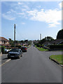
3
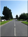
Pelham Rise
The road was constructed in the late 1970s to serve as an access route for the new estates and closes springing up as the northern part of Peacehaven from Firle Road to Telscombe Road had many of its vacant plots filled. The road heads east from Roderick Avenue before turning north towards Telscombe Road. This looks southwards past the junction with Glynn Road and the entrance to the business units next to Lower Hoddern Farm.
Image: © Simon Carey
Taken: 16 Jun 2012
0.11 miles
4
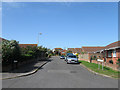
Badgers Field
Small cul de sac off Glynn Road developed during the mid to late 1980s as part of the infilling of vacant plots between Firle Road and Telscombe Road.
Image: © Simon Carey
Taken: 16 Jun 2012
0.13 miles
5
Cripps Avenue
One of the original roads of the town that ran north from Glynn Road to Telscombe Road. When the northern end of Peacehaven was developed a new access route, Pelham Rise, was built which subsequently took over the northern end of this road up to Telscombe Road.
Image: © Simon Carey
Taken: 2 Jun 2012
0.15 miles
6

Business Units, Lower Hoddern Farm
Viewed from the entrance off Pelham Rise. Lower Hoddern Farm lies beyond the trees to the right.
Image: © Simon Carey
Taken: 2 Jun 2012
0.18 miles
7
Roderick Avenue
The longest of the north-south avenues in Peacehaven and the first to be made up. The straight road originally stretched from the cliff top to Valley Road and was later extended further to The Lookout and was the major access route to the north of the town. However, during the 1970s, the section between Arundel Road and Balcombe Road was largely removed to construct the Meridian Centre with the remnant turned into a delivery access road that was later renamed Roderick Way. Driving its entire length is also now impossible, there is no longer any access from the A259 whilst this section now ends at the junction with Glynn Road, a barrier prevents any further move southwards.
Image: © Simon Carey
Taken: 16 Jun 2012
0.18 miles
8
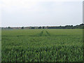
Gallows Hill (1)
The name of the field according to Piddinghoe's 1843 tithe map. This is the southern end south of Image, the northern end running south of Lodge Hill. The estates of northern Peacehaven can be seen at the opposite end of the field.
Image: © Simon Carey
Taken: 2 Jun 2012
0.19 miles
9
Abbey Close
Small cul-de-sac running north of Heathy Brow built in the early 1980s as the northern end of Peacehaven was redeveloped.
Image: © Simon Carey
Taken: 9 Jun 2012
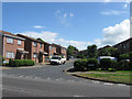
0.21 miles
10
Coney Furlong
Small estate of Pelham Rise constructed in the early 1980s.
Image: © Simon Carey
Taken: 16 Jun 2012
0.22 miles