IMAGES TAKEN NEAR TO
Mount Road, BOURNEMOUTH, BH11 8AW
Introduction
This page details the photographs taken nearby to Mount Road, BH11 8AW by members of the Geograph project.
The Geograph project started in 2005 with the aim of publishing, organising and preserving representative images for every square kilometre of Great Britain, Ireland and the Isle of Man.

There are currently over 7.5m images from over14,400 individuals and you can help contribute to the project by visiting https://www.geograph.org.uk
Image Map
Images are licensed for reuse under creativecommons.org/licenses/by-sa/2.0
Notes
- Clicking on the map will re-center to the selected point.
- The higher the marker number, the further away the image location is from the centre of the postcode.
Image Listing (74 Images Found)
Images are licensed for reuse under creativecommons.org/licenses/by-sa/2.0
Image
Details
Distance
1

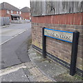
West Howe: Mount Road
When the large 1950s West Howe council estate was built, Mount Road utilised an original farm track or lane: overlaying older with present-day maps, the course is very obvious.
The sign is an early version of a standard Bournemouth design from around 2000, the early version recognisable by a slightly more emboldened typeface, aligned to the left when on two lines or, never on the newer versions, written on a single line as here.
This is photo no.286 of a series of 453 in my coronavirus lockdown walking project:
See Link for the complete set of photos.
Image: © Chris Downer
Taken: 18 Apr 2020
0.02 miles
2
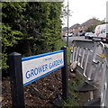
West Howe: Grower Gardens
Right by the heart of the large 1950s West Howe council estate, Grower Gardens is one of relatively few roads to have been added to the estate since it was built.
Along with Hanlon Close which comes off it, it is built on the site of the old Heathlands First School, which closed in around 1993 when it amalgamated with Heathlands Junior to become an all-through primary school, and was all accommodated on the Junior site. The school buildings were destroyed by fire shortly after closure and before official demolition was due.
The sign is a modern one, from 2010-15 when this more modern, abstract emblem rather than the traditional town coat of arms as the working logo of the council. It is currently barricaded in by a small cordon for road works by the gas board.
This is photo no.177 of a series of 453 in my coronavirus lockdown walking project:
See https://www.geograph.org.uk/article/My-2020-Coronavirus-Lockdown-walking-project for the complete set of photos.
Image: © Chris Downer
Taken: 18 Apr 2020
0.04 miles
3
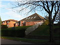
West Howe: St. Philip?s Church
A modern church serving the large West Howe council estate.
Image: © Chris Downer
Taken: 23 Nov 2008
0.06 miles
4
West Howe: Hanlon Close
Hanlon Close comes off Grower Gardens, both dead ends for vehicles, and are two of relatively few roads to have been added to the large West Howe council estate since it was built in the 1950s.
They are built on the site of the old Heathlands First School, which closed in around 1993 when it amalgamated with Heathlands Junior to become an all-through primary school, and was all accommodated on the Junior site. The school buildings were destroyed by fire shortly after closure and before official demolition was due.
The sign is an early version of a standard Bournemouth design from around 2000, the early version recognisable by a slightly more emboldened typeface, aligned to the left when on two lines or, never on the newer versions, written on a single line as here.
This is photo no.180 of a series of 453 in my coronavirus lockdown walking project:
See https://www.geograph.org.uk/article/My-2020-Coronavirus-Lockdown-walking-project for the complete set of photos.
Image: © Chris Downer
Taken: 18 Apr 2020
0.07 miles
5

West Howe: postbox № BH11 67, Rochester Road
This small postbox is on the corner of Rochester and Ritchie Roads. The surrounding semi-detached houses are typical of this large council estate.
Image: © Chris Downer
Taken: 17 Aug 2008
0.08 miles
6
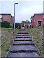
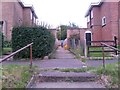
West Howe: steps to Moore Avenue houses and footpath U31
The houses on the eastern side of this segment of Moore Avenue are up a grass bank from the main carriageway. These steps therefore provide access to them - a ramped path is available nearby too.
The steps are directly in line with a public footpath heading between these two houses - see Image] for more discussion and further links.
Image: © Chris Downer
Taken: 27 Jun 2016
0.11 miles
7
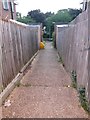
West Howe: footpath U31 to Moore Avenue
Looking down this short public footpath from its top end.
See Image] for an upward view and more discussion; and Image for a view along the path just behind us, onto which this one leads.
Image: © Chris Downer
Taken: 27 Jun 2016
0.11 miles
8
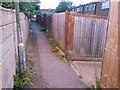
West Howe: footpath U31 to Cunningham Close (almost)
A man walks up this short public footpath that leads between houses in Moore Avenue to a path (not also designated a public footpath) running behind them. The end of Cunningham Close is just behind the wall at the back, but the path leads to it only indirectly (see Image).
See Image for a view down the path from the end, and Image for a view of the steps on which we are standing.
Image: © Chris Downer
Taken: 27 Jun 2016
0.11 miles
9
West Howe: footpath U31 is to the right
Looking along a path at the back of odd-numbered houses in Moore Avenue. Unlike this path, the one to our right is designated a public right of way, number U31. A short distance ahead of us, where the dark scar in the tarmac comes to an end, an opening in the wall leads to Cunningham Close. See Image for more discussion, and Image] for a view down the path from this top end.
Image: © Chris Downer
Taken: 27 Jun 2016
0.11 miles
10
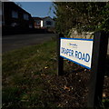
West Howe: Draper Road
Looking along Draper Road from its northern end, on Moore Avenue. It is in the heart of the large West Howe 1950s council estate - one half of a typical council semi is in the background along with a more modern bungalow.
The sign is a modern one, from 2010-15 when this more modern, abstract emblem rather than the traditional town coat of arms as the working logo of the council.
This is photo no.114 of a series of 453 in my coronavirus lockdown walking project:
See https://www.geograph.org.uk/article/My-2020-Coronavirus-Lockdown-walking-project for the complete set of photos.
Image: © Chris Downer
Taken: 11 Apr 2020
0.11 miles