IMAGES TAKEN NEAR TO
Amroth Gardens, WORCESTER, WR4 0EP
Introduction
This page details the photographs taken nearby to Amroth Gardens, WR4 0EP by members of the Geograph project.
The Geograph project started in 2005 with the aim of publishing, organising and preserving representative images for every square kilometre of Great Britain, Ireland and the Isle of Man.

There are currently over 7.5m images from over14,400 individuals and you can help contribute to the project by visiting https://www.geograph.org.uk
Image Map
Images are licensed for reuse under creativecommons.org/licenses/by-sa/2.0
Notes
- Clicking on the map will re-center to the selected point.
- The higher the marker number, the further away the image location is from the centre of the postcode.
Image Listing (79 Images Found)
Images are licensed for reuse under creativecommons.org/licenses/by-sa/2.0
Image
Details
Distance
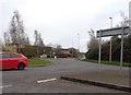
1
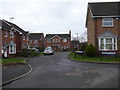
Junction of Tiverton Close and Amroth Gardens
In the Berkeley-Beverborne section of Warndon Villages. Tiverton close is also behind the photographer and curves sharply to the right at the sign while Amroth Gardens are straight ahead.
Image: © Chris Allen
Taken: 24 Jan 2020
0.02 miles
2
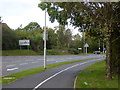
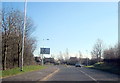
B6438 - Warndon Villages
Looking towards the roundabout where the B6439 passes across with the M5 to the right and Blackpole to the left. This road is the spine through Warndon Villages and in the opposite direction ends opposite the entrance to Worcestershire royal Hospital.
Image: © Chris Allen
Taken: 6 Oct 2019
0.02 miles
3
Homestead Avenue, Wall Meadow
This show the junction of Homestead Avenue (which passes out of view to the left) with the B4638 Woodgreen Road. In the distance the roundabout marks the junction with the B4639.
Image: © Chris Allen
Taken: 1 Dec 2019
0.03 miles
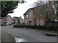
4
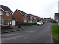
Tiverton Close, Berkeley-Beverborne
Tiverton Close curves round to the right by the street sign on the extreme right while Amroth Gardens are straight ahead. The Warndon Villages complex has a very large number of named streets.
Image: © Chris Allen
Taken: 24 Jan 2020
0.03 miles
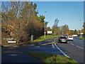
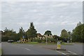
5
Junction of B4639 and B4638 Worcester
Brindley Road, Cotswold Way (B4639), Woodgreen Drive (B4638) and Berkeley Way (B4639) form a roundabout on the edge of the Warndon Villages. To the right (Woodgreen Drive) is a large housing development and to the left (Brindley Road) is industry, but of a clean nature.
Image: © Jeff Gogarty
Taken: 18 Dec 2015
0.04 miles
6
Roundabout, Berkeley Way, Warndon, Worcester
Image: © David Smith
Taken: 8 Oct 2016
0.05 miles
7
Dunster Close, Berkeley-Beverborne
A cul-de-sac in Warndon Villages. I have set myself a task to photograph every named street in the four separate complexes that make up the villages (Harley, Lyppard, Berkeley and Meadow). However, Covid-19 has put that project on hold at the moment.
Image: © Chris Allen
Taken: 24 Jan 2020
0.05 miles
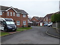
8
Chepstow Avenue with Blair Close to the right
In the part of Warndon Villages known as Berkeley-Beverborne. Warndon Villages is a large area of interlinked modern housing developments in Worcester.
Image: © Chris Allen
Taken: 6 Oct 2019
0.05 miles
10
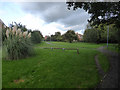
Paths and grass in Warndon Villages
A pleasant area among all the housing estates making up Warndon Villages. I believe this area is Berkeley-Beverborne,
Image: © Chris Allen
Taken: 6 Oct 2019
0.06 miles