IMAGES TAKEN NEAR TO
Whitemans Green, HAYWARDS HEATH, RH17 5DA
Introduction
This page details the photographs taken nearby to Whitemans Green, RH17 5DA by members of the Geograph project.
The Geograph project started in 2005 with the aim of publishing, organising and preserving representative images for every square kilometre of Great Britain, Ireland and the Isle of Man.

There are currently over 7.5m images from over14,400 individuals and you can help contribute to the project by visiting https://www.geograph.org.uk
Image Map
Images are licensed for reuse under creativecommons.org/licenses/by-sa/2.0
Notes
- Clicking on the map will re-center to the selected point.
- The higher the marker number, the further away the image location is from the centre of the postcode.
Image Listing (56 Images Found)
Images are licensed for reuse under creativecommons.org/licenses/by-sa/2.0
Image
Details
Distance
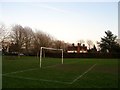
1
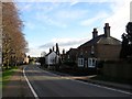
Beaconsfield Villas, Whitemans Green, Whitemans Green
Image: © Simon Carey
Taken: 20 Dec 2014
0.03 miles
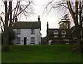
2
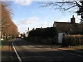
The Old Cottage, Whitemans Green, Whitemans Green
The white building on the right dates from around 1530 and was originally a hall house that was later extended around the early 18th century. Originally built opposite a small common called Whitemans Green which has since given its name to both the road, the B2115, and the settlement around it.
Image: © Simon Carey
Taken: 24 Jan 2015
0.03 miles
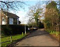
3
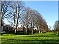
Limes, Whitemans Green
The row of limes were planted by the Cuckfield Improvement Association which existed from 1902-39. Whitemans Green is the name of both the open space and hamlet which sprung up around it.
Image: © Simon Carey
Taken: 6 Dec 2014
0.03 miles
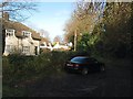
5
Stroods, Whitemans Green, Whitemans Green
The current house was built between the wars and was named after an older property to the west which appears on the 1881 OS map but disappears thereafter. It was roughly located where the current car park for Whitemans Green playing fields is.
Image: © Simon Carey
Taken: 24 Jan 2015
0.04 miles
6
Junipers and Lamb Cottages, Whitemans Green, Whitemans Green
Both dwellings ace out onto the B2115 and the village green beyond it. Junipers is the white building on the left and dates to the 18th century. On the right are Lamb Cottages formerly a beer house called The Lamb. Number 1 on the left dates from the 16th century whilst number 2 was an extension added when it was a pub in the mid 19th, the same time the former was refronted in brick. Have yet to discover when it ceased trading as a beer house.
Image: © Simon Carey
Taken: 20 Dec 2014
0.04 miles
7
Blakeney House, Whitemans Green
Situated on the edge of the green and built during the 1980s. The drive provides access for Image, Image, Image and Image
Image: © Simon Carey
Taken: 20 Dec 2014
0.05 miles
8
Cherry Trees, Whitemans Green
Four pairs of maisonettes built between the wars on the site of former allotment gardens. The drive heads south from the B2115 and is also the route of a public footpath.
Image: © Simon Carey
Taken: 20 Dec 2014
0.05 miles
9
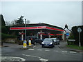
Petrol Station, Whitemans Green, Cuckfield
Image: © Stacey Harris
Taken: 23 Jan 2010
0.06 miles
10
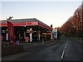
Petrol Filling Station, Whitemans Green, Whitemans Green
Once the site of the village smithy by the 1937-38 OS map it had become a petrol filling station which it has been ever since. To the right are a line of limes planted on the former common called Whitemans Green in the first decade of the 20th century. As well as the green Whitemans Green also refers to the B2115 as well as the settlement.
Image: © Simon Carey
Taken: 6 Dec 2014
0.07 miles