IMAGES TAKEN NEAR TO
Williams Close, Kent Science Park, SITTINGBOURNE, ME9 8FL
Introduction
This page details the photographs taken nearby to Williams Close, Kent Science Park, ME9 8FL by members of the Geograph project.
The Geograph project started in 2005 with the aim of publishing, organising and preserving representative images for every square kilometre of Great Britain, Ireland and the Isle of Man.

There are currently over 7.5m images from over14,400 individuals and you can help contribute to the project by visiting https://www.geograph.org.uk
Image Map
Images are licensed for reuse under creativecommons.org/licenses/by-sa/2.0
Notes
- Clicking on the map will re-center to the selected point.
- The higher the marker number, the further away the image location is from the centre of the postcode.
Image Listing (11 Images Found)
Images are licensed for reuse under creativecommons.org/licenses/by-sa/2.0
Image
Details
Distance
1
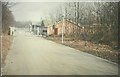
Part of Sittingbourne Research Centre in 1969
These buildings formed part of the research establishment of Shell Research Ltd when it was based at Sittingbourne Research Centre. It was known as ‘Cromers Wood’ and I worked in it during two different periods when I was employed by the company. Due to the buildings being built on a slope, there was a flight of steps between the bottom section and the top, which backed onto the wood. On 7 March 1969, part of the top section began to show the effects of acute subsidence and had to be shored up to prevent its collapse. The subsidence was remedied by digging a trench along the back of the upper section for drainage pipes. Part of this upper section was demolished and rebuilt. The site has since become Broadoak Enterprise Village.
Image: © John Baker
Taken: Unknown
0.14 miles
2
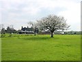
Woodstock Cottage Farm
Just south of the Kent Science Park.
Image: © Penny Mayes
Taken: 19 Apr 2005
0.15 miles
3
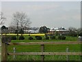
Kent Science Park
The south east side of the park.
Image: © Penny Mayes
Taken: 19 Apr 2005
0.15 miles
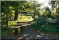
4
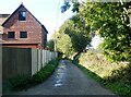
Path between Cromer's Wood and Broadoak Road
With Shooting Box Cottage on the left. Cromer's Wood is a 28 hectare ancient semi-natural woodland that sits on the southeast side of a dry slope valley. It was donated by Shell Research Ltd. to Kent Trust for Nature Conservation, now known as Kent Wildlife Trust, in 1996.
Image: © pam fray
Taken: 18 Oct 2022
0.19 miles
5
Kent Science Park from the south
Built as a Shell Agricultural Research centre there are proposals to expand the site, currently used by a variety of businesses some of which are science based.
Image: © Penny Mayes
Taken: 17 Apr 2005
0.19 miles
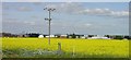
6
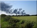
Wheat beside Broadoak Road
The buildings partially hidden by trees on the left are on the Kent Science Park (formerly Shell Research). The fire was on a building site near Sittingbourne Memorial Hospital about 3km away.
Image: © Penny Mayes
Taken: 30 Jun 2006
0.19 miles
7
Entrance to Cromer's Wood, near Sittingbourne
This 28 hectare ancient semi-natural woodland sits on the southeast side of a dry slope valley. It was donated by Shell Research Ltd. to Kent Trust for Nature Conservation, now known as Kent Wildlife Trust, in 1996.
Image: © pam fray
Taken: 18 Oct 2022
0.22 miles
8
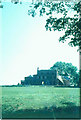
Woodstock House, 1971
Woodstock House was built in the early 1780s by Abraham Chambers. It was requisitioned by the Government during both world wars. Shortly after the estate became Shell property in 1945, land to the north of Broad Oak Road, and with it Woodstock House, was requisitioned by the Kent Farm Institute. For some time the building was used by Kent Fire Brigade as a practice site. Not surprisingly it became structurally unsound. Soon after this picture was taken, it was demolished.
Image: © John Baker
Taken: Unknown
0.24 miles
9
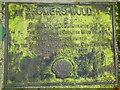
Metal plaque, Cromer's Wood, near Sittingbourne
Cromer's Wood is a 28 hectare ancient semi-natural woodland that sits on the southeast side of a dry slope valley. It was donated by Shell Research Ltd. to Kent Trust for Nature Conservation, now known as Kent Wildlife Trust, in 1996, as this plaque informs the public.
Image: © pam fray
Taken: 18 Oct 2022
0.24 miles
10
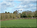
Three chimneys
On the Kent Science Park.
Image: © Robin Webster
Taken: 4 Apr 2015
0.24 miles