IMAGES TAKEN NEAR TO
Clovelly Road, MANCHESTER, M21 8XU
Introduction
This page details the photographs taken nearby to Clovelly Road, M21 8XU by members of the Geograph project.
The Geograph project started in 2005 with the aim of publishing, organising and preserving representative images for every square kilometre of Great Britain, Ireland and the Isle of Man.

There are currently over 7.5m images from over14,400 individuals and you can help contribute to the project by visiting https://www.geograph.org.uk
Image Map
Images are licensed for reuse under creativecommons.org/licenses/by-sa/2.0
Notes
- Clicking on the map will re-center to the selected point.
- The higher the marker number, the further away the image location is from the centre of the postcode.
Image Listing (96 Images Found)
Images are licensed for reuse under creativecommons.org/licenses/by-sa/2.0
Image
Details
Distance
1
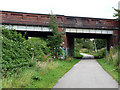
Bridge carrying St Werburgh's Road over the Fallowfield Loop Cycleway
Since this photo was taken this section of disused railway line has been re-opened as part of the Metrolink tram network. The cycle path has been re-aligned to run under the previously unused bridge span to the left of the photo.
Image: © Phil Champion
Taken: 29 Aug 2009
0.02 miles
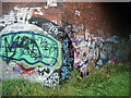
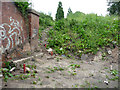
2
Graffiti under northern span, St Werburgh's Road railway bridge
The railway bridge at St Werburgh's road was constructed (or reconstructed) with a future doubling of the line in mind. The northern span was never used. Since the closure of the line in 1988, the Fallowfield Loop cycleway has been constructed through the southern span. This is to be diverted through the unused northern span to accommodate the extension of the Metrolink network and the construction of a tram station.
Image: © Phil Champion
Taken: 29 Aug 2009
0.02 miles
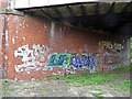
3
Graffiti beneath southern span of St Werburgh's Road railway bridge
On the pillar separating the southern and northern spans. Since taking this photo the disused railway line has been re-opened as part of the Metrolink tram network and the graffiti cleaned off.
Image: © Phil Champion
Taken: 29 Aug 2009
0.02 miles
4
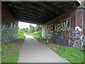
Fallowfield Loop Cycleway at St Werburgh's Road bridge
Looking towards the site of Chorlton Junction where the Fallowfield Loop line (built by the Manchester, Sheffield and Lincolnshire Railway) diverged from the Midland Railway's Manchester South District Line towards Didsbury and Tiviot Dale. Passenger services ceased in the 1960s, the Fallowfield Loop being for freight services until 1989. The cycleway was constructed in the 1990s and was originally planned to terminate at the junction and join St Werburgh's Road via a ramp. I recall there was an issue with ownership of land on the north east side of the bridge and the ramp was fenced off and obstructed with boulders. This led to the extension of the route under the bridge and along the section of line in the direction of the site of Chorlton-cum-Hardy station as far as the end of Sidbury Road.
Since this photo was taken this section of line has been re-opened as part of the expansion of the Metrolink tram network. A new tram station has been built on the opposite side of the bridge. Fortunately the road bridge was built with two spans to accommodate a future doubling of the tracks that never took place. The cycle path has been diverted to run through the unused northerly span.
Image: © Phil Champion
Taken: 29 Aug 2009
0.02 miles
5
Land below St Werburgh's Road bridge
This location was just east of the unused northern span of the railway bridge near Chorlton Junction. Since this photo was taken the disused railway line has been re-opened as part of the expansion of the Metrolink tram network, and St Werburgh's Road station constructed on this site. The vegetation has been replaced with a lift / stairway tower. Note the survey pegs.
Image: © Phil Champion
Taken: 29 Aug 2009
0.02 miles
6
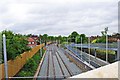
Manchester Metrolink near St. Werburgh's Road, Chorlton-cum-Hardy
The opening of the new extension to St. Werburgh's Road is now imminent. This view is looking in the direction of Manchester city centre. On the right is the access ramp from St. Werburgh's Road. This continues as a footpath under the bridge to give access to the platforms of the St. Werburgh's Road tram stop. Photographed from the bridge carrying St. Werburgh's Road across the tramway, part of the parapet of which is in the right hand bottom corner.
Image
Image: © P L Chadwick
Taken: 7 May 2011
0.03 miles
7
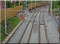
Manchester Metrolink near St. Werburgh's Road, Chorlton-cum-Hardy
When this photograph was taken in May 2011, a temporary barrier had been placed across the tracks, as can be seen in this view. Photographed from the bridge taking St. Werburgh's Road across the tramway.
Image
Image: © L S Wilson
Taken: 7 May 2011
0.03 miles
8
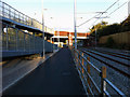
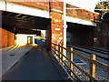
Cycle path and ramp west of St Werburgh's Road Metrolink station, Chorlton
The section of cycle path along the disused railway trackbed west of the St Werburgh's Road bridge has been moved sideways to accommodate the tram lines, and a very long ramp constructed to provide disable access between platform and road level. I would imagine most wheelchair users would use the lift instead.
Image: © Phil Champion
Taken: 4 Aug 2011
0.03 miles
9
Cycle path near St Werburghs Road Metrolink station, Chorlton
Opened to St Werburghs Road in July 2011, the South Manchester Metrolink line utilises the trackbed of the Midland Railway's South Manchester District Line. At Chorlton Junction, where the tram station now stands on the opposite side of the bridge, the former Manchester Sheffield & Lincolnshire Railway's Falowfield Loop Line towards Guide Bridge diverged from the South District Line.
In the 1990s the Fallowfield Loop was converted into a cycle path, which also continued under the bridge span seen on the right hand side for a short distance. Fortunately the bridge had been built to accommodate future doubling between Chorlton-cum-Hardy station and Chorlton Junction (which did not take place). This has allowed the cycle path to be diverted through the unused span, crossing the tram tracks a little way to the west.
Image: © Phil Champion
Taken: 4 Aug 2011
0.04 miles
10
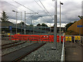
Cycle path level crossing west of St Werburgh's Road Metrolink stop
This photo was taken a week before the opening of the Metrolink extension to Chorlton-cum-Hardy and St Werburgh's Road. For a number of years previously the disused railway trackbed had been used as part of a popular cycle path. In utilising the former heavy rail line towards Chorlton Junction as part of the light rail network, it has been necessary to realign the cycleway to run along on side of the tram lines.
Beyond the level crossing a long ramp can be seen, which provides step free access to the tram station.
Image: © Phil Champion
Taken: 18 Jun 2011
0.04 miles