Fallowfield Loop Cycleway at St Werburgh's Road bridge
Introduction
The photograph on this page of Fallowfield Loop Cycleway at St Werburgh's Road bridge by Phil Champion as part of the Geograph project.
The Geograph project started in 2005 with the aim of publishing, organising and preserving representative images for every square kilometre of Great Britain, Ireland and the Isle of Man.

There are currently over 7.5m images from over 14,400 individuals and you can help contribute to the project by visiting https://www.geograph.org.uk
Fallowfield Loop Cycleway at St Werburgh's Road bridge
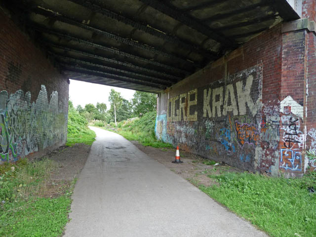
Image: © Phil Champion Taken: 29 Aug 2009
Looking towards the site of Chorlton Junction where the Fallowfield Loop line (built by the Manchester, Sheffield and Lincolnshire Railway) diverged from the Midland Railway's Manchester South District Line towards Didsbury and Tiviot Dale. Passenger services ceased in the 1960s, the Fallowfield Loop being for freight services until 1989. The cycleway was constructed in the 1990s and was originally planned to terminate at the junction and join St Werburgh's Road via a ramp. I recall there was an issue with ownership of land on the north east side of the bridge and the ramp was fenced off and obstructed with boulders. This led to the extension of the route under the bridge and along the section of line in the direction of the site of Chorlton-cum-Hardy station as far as the end of Sidbury Road. Since this photo was taken this section of line has been re-opened as part of the expansion of the Metrolink tram network. A new tram station has been built on the opposite side of the bridge. Fortunately the road bridge was built with two spans to accommodate a future doubling of the tracks that never took place. The cycle path has been diverted to run through the unused northerly span.
Images are licensed for reuse under creativecommons.org/licenses/by-sa/2.0
Image Location
Latitude
53.438875
Longitude
-2.267913