IMAGES TAKEN NEAR TO
Station Road, LEIGHTON BUZZARD, LU7 9JG
Introduction
This page details the photographs taken nearby to Station Road, LU7 9JG by members of the Geograph project.
The Geograph project started in 2005 with the aim of publishing, organising and preserving representative images for every square kilometre of Great Britain, Ireland and the Isle of Man.

There are currently over 7.5m images from over14,400 individuals and you can help contribute to the project by visiting https://www.geograph.org.uk
Image Map
Images are licensed for reuse under creativecommons.org/licenses/by-sa/2.0
Notes
- Clicking on the map will re-center to the selected point.
- The higher the marker number, the further away the image location is from the centre of the postcode.
Image Listing (9 Images Found)
Images are licensed for reuse under creativecommons.org/licenses/by-sa/2.0
Image
Details
Distance
1
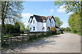
Stanbridgeford Station House
Stanbridgeford Station was on the Leighton Buzzard to Dunstable North branch of the London & North Western Railway. The railway passed immediately in front of the house and there were platforms for both tracks on the left of the picture. The Stanbridge to Totternhoe road came over a level crossing where the trellis fence is. The trackbed east from here forms the Sewell Greenway, part of National Cyclepath No. 6.
Image: © Bob Walters
Taken: 21 Apr 2022
0.06 miles
2
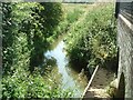
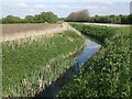
Ouzel Brook, Stanbridgeford
The Ouzel Brook seen here joins the River Ouzel (which is not much bigger) near The Rye. This photo just sneaks into this square - the bridge being bisected by the gridline.
Image: © Rob Farrow
Taken: 29 Jun 2006
0.08 miles
3
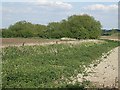
Hidden brook
The Ouzel Brook is so diminutive at this point that from most viewpoints it is practically invisible. But trust me, it is there, running in a little dip between the green vegetation and the fence posts. To actually see this magnificent watercourse, have a look at Image]
Image: © Rob Farrow
Taken: 29 Apr 2009
0.10 miles
4
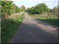
Sewell Greenway - Cycle path
Sewell Greenway is a cycle path that runs mainly along a disused railway line. This is the very start of it as it leaves Stanbridge Road (now itself a quiet cul-de-sac). A sign by the entrance to this path states that it is 2 miles to Dunstable. Only the first few yards, seen here, are inside this square as it soon dips southwards into SP9722
Image: © Rob Farrow
Taken: 29 Apr 2009
0.11 miles
5
Kink in the Ouzel Brook
Taken from the Stanbridge Road looking at a little kink in the Ouzel Brook. As can be seen, it is hardly a roaring torrent at this point. The direction of flow - or should that be trickle - is roughly westwards, that is towards the camera. In a few yards it will flow under the bridge seen in Image] it then continues westwards to join the River Ouzel near The Rye.
Image: © Rob Farrow
Taken: 29 Apr 2009
0.13 miles
7
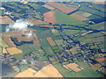
Stanbridgeford and Stanbridge
A view south from over Hockciffe. A strange diversion from a straight line track at Stanbridgeford, that appears to by-pass nothing, except to provide a better line for the A505 from Houghton Regis.
Image: © M J Richardson
Taken: 12 Jul 2017
0.20 miles
8
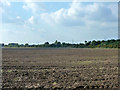
Ploughed field south of A505
The A505 is behind the hedge on the right.
Image: © Robin Webster
Taken: 19 Sep 2015
0.22 miles
9
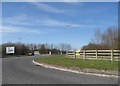
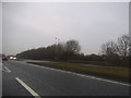
Stanbridge Road at the junction of the A505
Image: © David Howard
Taken: 20 Apr 2016
0.23 miles