IMAGES TAKEN NEAR TO
Resolution Road, ASHBY-DE-LA-ZOUCH, LE65 1PF
Introduction
This page details the photographs taken nearby to Resolution Road, LE65 1PF by members of the Geograph project.
The Geograph project started in 2005 with the aim of publishing, organising and preserving representative images for every square kilometre of Great Britain, Ireland and the Isle of Man.

There are currently over 7.5m images from over14,400 individuals and you can help contribute to the project by visiting https://www.geograph.org.uk
Image Map
Images are licensed for reuse under creativecommons.org/licenses/by-sa/2.0
Notes
- Clicking on the map will re-center to the selected point.
- The higher the marker number, the further away the image location is from the centre of the postcode.
Image Listing (18 Images Found)
Images are licensed for reuse under creativecommons.org/licenses/by-sa/2.0
Image
Details
Distance
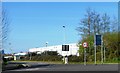
1
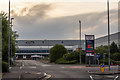
Resolution Road, Ashby-de-la-Zouch
An industrial estate to the East of Ashby, with the McVities distribution centre its flagship unit.
Image: © Oliver Mills
Taken: 8 Jun 2020
0.09 miles
2
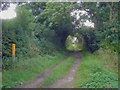
Entrance to Featherbed Lane
Looking south from the junction with the Ivanhoe Way.
Image: © Trevor Rickard
Taken: 15 Aug 2009
0.12 miles
3
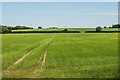
The Money Hill region of Ashby-de-la-Zouch
A large area of fields and farmland is bounded by the A511 Ashby Bypass to the North-West, North Street to the South, and Smisby Road and various housing estates to the West. There have been plans for a while to develop much of this space into housing.
Viewed from the Ivanhoe Way/Cross Britain Way, near its connection with Featherbed Lane.
Image: © Oliver Mills
Taken: 2 Jun 2020
0.13 miles
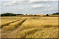
4
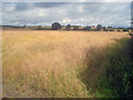
Rape crop north of Ashby
Looking north from the public footpath. Most of the fields on this hillside seem to be rape or wheat. This field is very ripe and about to be harvested in late August, given a few dry days.
http://www.ukagriculture.com/crops/oil_seed_rape.cfm
Image: © Trevor Rickard
Taken: 15 Aug 2009
0.13 miles
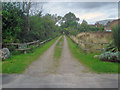
6
A field in the Money Hill region, Ashby-de-la-Zouch
Taken from the public footpath at the end of Featherbed Lane. All of this land is expected to be developed for housing soon. The small copse of trees on the left is marked on many maps to feature a "Lawn Barn" and a spring. It is legally inaccessible due to there being no public footpaths or open access areas between here and there, although from this position there is no physical impedance to access.
Image: © Oliver Mills
Taken: 12 Aug 2021
0.13 miles
7
Featherbed Lane
Heading north out of the housing estate is the intriguingly-named Featherbed Lane. The sign on the left reads 'No vehicles beyond this point'. The housing estate carries on off to the right along Astley Way.
Image: © Trevor Rickard
Taken: 15 Aug 2009
0.15 miles
8
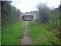
The Ivanhoe Way
Heading north-east out of Ashby and under the A511. The Ivanhoe Way is a 35 mile circular walk around north Leicestershire, celebrating Sir Walter Scott's 1820 novel 'Ivanhoe'. Scott chose Ashby de la Zouch castle and the surrounding countryside as one of the settings used in the book, having got to know the area whilst staying at nearby Coleorton Hall.
http://www.leics.gov.uk/index/environment/countryside/walking/ivanhoeway.htm
Image: © Trevor Rickard
Taken: 15 Aug 2009
0.17 miles
9
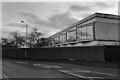
Ashfield House, Ashby-de-la-Zouch
A contemporary office building off Resolution Road, now closed and intended for demolition. Planning for demolition and replacement with a Lidl supermarket is still under determination.
Camera: Olympus Mju ii
Film: Kentmere 400
Image: © Oliver Mills
Taken: 24 Dec 2023
0.17 miles
10
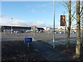
How did we EVER manage without?
"We're open 24 hours", says the sign (apart from Sundays, when the times are more limited). 24-hour supermarket shopping is a pastime for people who really need to get out more!
Image: © Richard Law
Taken: 5 Feb 2013
0.20 miles