IMAGES TAKEN NEAR TO
Montgomery Avenue, BOURNEMOUTH, BH11 8BP
Introduction
This page details the photographs taken nearby to Montgomery Avenue, BH11 8BP by members of the Geograph project.
The Geograph project started in 2005 with the aim of publishing, organising and preserving representative images for every square kilometre of Great Britain, Ireland and the Isle of Man.

There are currently over 7.5m images from over14,400 individuals and you can help contribute to the project by visiting https://www.geograph.org.uk
Image Map (Loading...)


Getting Data...Please wait
Leaflet Map data © OpenStreetMap
Images are licensed for reuse under creativecommons.org/licenses/by-sa/2.0
Notes
- Clicking on the map will re-center to the selected point.
- The higher the marker number, the further away the image location is from the centre of the postcode.
Image Listing (104 Images Found)
Images are licensed for reuse under creativecommons.org/licenses/by-sa/2.0
Image
Details
Distance
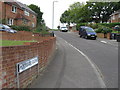
1
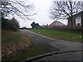
West Howe: footpath U32 reaches Rochester Road
Darkness really is almost upon us now, as we look along this public footpath from South Kinson Drive, which emerges here onto the dead end of Rochester Road.
See Image] for the next view down the path behind us.
Image: © Chris Downer
Taken: 27 Jun 2016
0.08 miles
2
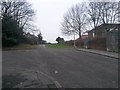
West Howe: across Tedder Close and down footpath U23
Looking across the junction of Tedder Close (onto Tedder Road) and beyond, down a short public footpath to Moorside Close. The mapped route of the public footpath begins at the steps just to the right of the road sign, although a step-free route is also available from the left.
See Image for a closer view of the path, with links to photos showing the uphill view.
Image: © Chris Downer
Taken: 9 Feb 2017
0.08 miles
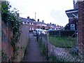
3
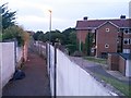
West Howe: footpath U23 to Moorside Close
A short path leading from Tedder Road (at the turning of Tedder Close) down to the dead end of Moorside Close - a pedestrian route down onto Moorside Road which we see crossing the picture at the bottom of the hill.
A step-free route is available a few yards to the left, at the other end of the railing.
See Image for the wider view from behind us, and Image for the view up the path from the Moorside Close end.
Before the West Howe estate was built in the 1950s/60s, this was the course of one of the few tracks across this open heathland, following the modern-day Mount Road behind us and continuing ahead, across Moorside Road to Kinson Road.
Image: © Chris Downer
Taken: 28 Jun 2016
0.09 miles
4
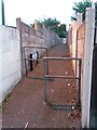
West Howe: footpath U23 to Tedder Road
Looking up this short public footpath from the top of Moorside Road. It arrives on Tedder Road via steps just out of picture to the left, but a ramped route is available to the right, in front of the railings.
See Image for the view up here from just behind us, and Image for the downward view along the path.
Image: © Chris Downer
Taken: 9 Feb 2017
0.09 miles
5
West Howe: the top of Moorside Close
Moorside Close comes to a dead end but a public footpath, numbered U23, continues the short distance up to Tedder Road.
See Image for a closer view of the path, with links to further photos looking down towards us.
Image: © Chris Downer
Taken: 9 Feb 2017
0.10 miles
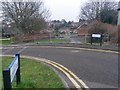
6

West Howe: Moorside Close
A small cul-de-sac off Moorside Road, hence the name, Moorside Close actually takes the course of one of the original tracks when this was all fields, before the large 1950s West Howe council estate was built: Behind us to the right is Ericksen Road, while at the top of the hill ahead is a path onto the eastern leg of Tedder Road, which continues diagonally into Mount Road – and that whole route is recognisable, when looking at older maps, as an original track or lane.
The sign is the standard Bournemouth nameplate from the 1980s, affixed with tubular steel which protrudes at each side.
This is photo no.281 of a series of 453 in my coronavirus lockdown walking project:
See https://www.geograph.org.uk/article/My-2020-Coronavirus-Lockdown-walking-project for the complete set of photos.
Image: © Chris Downer
Taken: 12 Apr 2020
0.10 miles
7
West Howe: footpath U32 and a block of flats
Looking down this public footpath and also over the wall to one of two blocks of flats on this site in South Kinson Drive.
See Image for the view up the path from the end, and Image for the other end behind us.
Image: © Chris Downer
Taken: 27 Jun 2016
0.10 miles
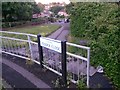
8
West Howe: footpath U32 to Rochester Road
This public footpath leads from South Kinson Drive to the dead end of Rochester Road, and has recently been given the name Poolside Walk - see Image for more discussion on the name.
See also Image for a picture looking towards us from just around the bend ahead.
Image: © Chris Downer
Taken: 27 Jun 2016
0.11 miles
9
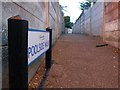
West Howe: Poolside Walk sign on footpath U32
Detail of the sign at the end of Image Many of the footpaths on the West Howe estate and thereabouts have been given names in the last couple of years, a safety initiative whose intention is that, in the event of calling for help, one's location can be more easily described. This one has been called Poolside Walk because just behind us is the site of the old swimming baths (Image) - although they were already demolished when the name was coined.
See Image for a view towards us from just around the bend ahead.
Image: © Chris Downer
Taken: 27 Jun 2016
0.11 miles