IMAGES TAKEN NEAR TO
Redhall Close, HATFIELD, AL10 9EQ
Introduction
This page details the photographs taken nearby to Redhall Close, AL10 9EQ by members of the Geograph project.
The Geograph project started in 2005 with the aim of publishing, organising and preserving representative images for every square kilometre of Great Britain, Ireland and the Isle of Man.

There are currently over 7.5m images from over14,400 individuals and you can help contribute to the project by visiting https://www.geograph.org.uk
Image Map
Images are licensed for reuse under creativecommons.org/licenses/by-sa/2.0
Notes
- Clicking on the map will re-center to the selected point.
- The higher the marker number, the further away the image location is from the centre of the postcode.
Image Listing (17 Images Found)
Images are licensed for reuse under creativecommons.org/licenses/by-sa/2.0
Image
Details
Distance
1
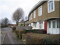
South Hatfield: Hazel Grove
Sinuous terraced housing, typical of South Hatfield.
Image: © Nigel Cox
Taken: 5 Jan 2007
0.14 miles
2
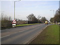
Roehyde Way, Hatfield. A1001
Photographed looking northwards towards the University of Hertfordshire and junction 3 of the A1(M). To the left of the picture is the A1(M), behind the fence, which runs parallel with Roehyde Way. This road was the A1 until the motorway was opened. Photograph taken outside the Quality Hotel. At the time of taking, there are roadworks at the roundabout outside the University on the corner of College Lane, hence the sign in the foreground.
Image: © Barry Lawson
Taken: 24 Jan 2006
0.16 miles
3
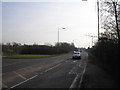
Roehyde Way, Hatfield. A1001
Photographed looking south, towards junction 2 of the A1(M), which is just at the top of the hill in the distance. Taken from opposite the Quality Hotel.
This road used to be the A1, until the motorway was opened.
Image: © Barry Lawson
Taken: 24 Jan 2006
0.16 miles
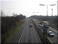
4
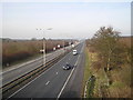
A1(M), North of Junction 2
Photographed from the junction 2 bridge, looking north towards junction 3.
At the time of taking, roadworks are being done at junction 3, hence the temporary sign near the centre of the photograph.
Image: © Barry Lawson
Taken: 24 Jan 2006
0.16 miles
5
A1(M), Hatfield, South of junction 2.
Photographed from the junction 2 bridge looking southwards. To the left is the southbound on slip.
Image: © Barry Lawson
Taken: 24 Jan 2006
0.16 miles
6
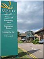
Quality Hotel South Hatfield
Fairly new hotel not sure about "wifi accepted"
Image: © Jack Hill
Taken: 7 Aug 2005
0.17 miles
8
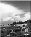
Lionel Brett council houses, south Hatfield, Herts, 1967
This northerly view from the back of my childhood house was taken when I was a teenager and starting to get interested in meteorology, hence the photo of the cumulonimbus 'anvil' cloud in the upper left.
I grew up on this council estate in south Hatfield which was built in 1956. It was designed by architect Lionel Brett (who became 4th Viscount Esher), and was innovative in that the terraced houses curved around the contours of the land in a series of sinuous crescents. They were warm and cosy and had sizeable gardens compared with modern-day council housing. The main distinctive feature was the low-angle single-pitch roof, constructed from timber overlain with aluminium cladding. Each terrace had a single modular roof extending over its entire length.
Unfortunately this design approximated to a crude aerofoil section which was spectacularly demonstrated during a severe gale on the night of 3rd-4th November 1957 when virtually all the houses facing in a westerly direction had their entire roof length lifted clean off and flung for distances of up to a 100 metres away. In this photo, the houses visible in the lower left all lost their roofs, which ended up in the gardens to the right. The houses which faced east (of which ours was fortunately one) were unaffected, as the 'leading edge' of the roof section was not facing into the wind.
I was 5 years old at the time and yet still clearly remember the screaming noise of the wind and the banging and clattering that went on. In those days, the street lighting was automatically switched off at midnight, so all this took place in pitch darkness in the early hours.
Altogether, over 50 houses were affected and lost their roofs. In those days hardly anyone had a telephone in the house; there was a long queue of people outside the callbox at the end of the street, waiting to phone the council. Amazingly, there were no fatalities and, as far as is known, not even any injuries - quite remarkable when you consider that great sheets of aluminium must have been flying around during the night - could have had your head off in no time.
The subsequent investigation and public enquiry found that in some cases the roofs had not been adequately fixed to the house walls. In the months that followed, repairs were made and structural improvements involving additional strong steel fixing brackets were installed.
The photo was taken 10 years after the event and there is no sign of what had occurred. I continued to live in the house until 1973 and there was never any further storm damage during that time. But to this day I still get jittery during gales.
Link to 'Hatfield's Night of Terror' storm damage webpage:
https://www.ourhatfield.org.uk/content/topics/housing/hatfields_night_of_terror
Image: © S Dumpleton
Taken: Unknown
0.18 miles
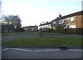
9
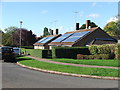
Redhall Drive
Solar PV panels recently installed on council houses
Image: © Charles Weaver
Taken: 17 Oct 2010
0.19 miles
10
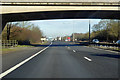
A1(M) northbound
Looking under the bridge at junction 2.
Image: © Robin Webster
Taken: 17 Feb 2018
0.19 miles