Lionel Brett council houses, south Hatfield, Herts, 1967
Introduction
The photograph on this page of Lionel Brett council houses, south Hatfield, Herts, 1967 by S Dumpleton as part of the Geograph project.
The Geograph project started in 2005 with the aim of publishing, organising and preserving representative images for every square kilometre of Great Britain, Ireland and the Isle of Man.

There are currently over 7.5m images from over 14,400 individuals and you can help contribute to the project by visiting https://www.geograph.org.uk
Lionel Brett council houses, south Hatfield, Herts, 1967
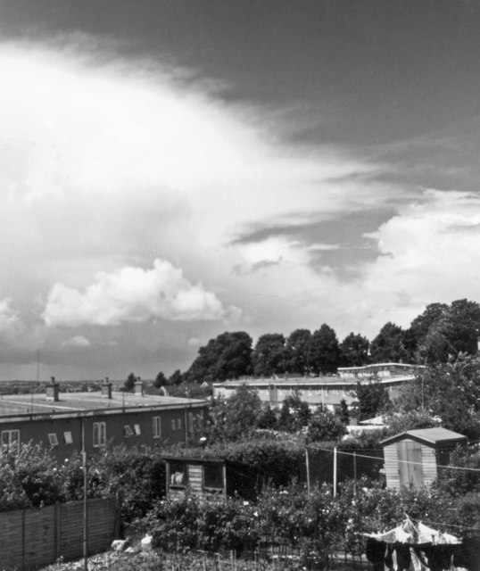
Image: © S Dumpleton Taken: Unknown
This northerly view from the back of my childhood house was taken when I was a teenager and starting to get interested in meteorology, hence the photo of the cumulonimbus 'anvil' cloud in the upper left. I grew up on this council estate in south Hatfield which was built in 1956. It was designed by architect Lionel Brett (who became 4th Viscount Esher), and was innovative in that the terraced houses curved around the contours of the land in a series of sinuous crescents. They were warm and cosy and had sizeable gardens compared with modern-day council housing. The main distinctive feature was the low-angle single-pitch roof, constructed from timber overlain with aluminium cladding. Each terrace had a single modular roof extending over its entire length. Unfortunately this design approximated to a crude aerofoil section which was spectacularly demonstrated during a severe gale on the night of 3rd-4th November 1957 when virtually all the houses facing in a westerly direction had their entire roof length lifted clean off and flung for distances of up to a 100 metres away. In this photo, the houses visible in the lower left all lost their roofs, which ended up in the gardens to the right. The houses which faced east (of which ours was fortunately one) were unaffected, as the 'leading edge' of the roof section was not facing into the wind. I was 5 years old at the time and yet still clearly remember the screaming noise of the wind and the banging and clattering that went on. In those days, the street lighting was automatically switched off at midnight, so all this took place in pitch darkness in the early hours. Altogether, over 50 houses were affected and lost their roofs. In those days hardly anyone had a telephone in the house; there was a long queue of people outside the callbox at the end of the street, waiting to phone the council. Amazingly, there were no fatalities and, as far as is known, not even any injuries - quite remarkable when you consider that great sheets of aluminium must have been flying around during the night - could have had your head off in no time. The subsequent investigation and public enquiry found that in some cases the roofs had not been adequately fixed to the house walls. In the months that followed, repairs were made and structural improvements involving additional strong steel fixing brackets were installed. The photo was taken 10 years after the event and there is no sign of what had occurred. I continued to live in the house until 1973 and there was never any further storm damage during that time. But to this day I still get jittery during gales. Link to 'Hatfield's Night of Terror' storm damage webpage: https://www.ourhatfield.org.uk/content/topics/housing/hatfields_night_of_terror
Images are licensed for reuse under creativecommons.org/licenses/by-sa/2.0
Image Location
Latitude
51.746403
Longitude
-0.237427