IMAGES TAKEN NEAR TO
Romsley View, BRIDGNORTH, WV15 6PL
Introduction
This page details the photographs taken nearby to Romsley View, WV15 6PL by members of the Geograph project.
The Geograph project started in 2005 with the aim of publishing, organising and preserving representative images for every square kilometre of Great Britain, Ireland and the Isle of Man.

There are currently over 7.5m images from over14,400 individuals and you can help contribute to the project by visiting https://www.geograph.org.uk
Image Map
Images are licensed for reuse under creativecommons.org/licenses/by-sa/2.0
Notes
- Clicking on the map will re-center to the selected point.
- The higher the marker number, the further away the image location is from the centre of the postcode.
Image Listing (56 Images Found)
Images are licensed for reuse under creativecommons.org/licenses/by-sa/2.0
Image
Details
Distance
1
Holmes Orchard
An estate of probably 1980s housing, built on what was presumably an old apple orchard.
Image: © Richard Law
Taken: 3 Dec 2017
0.10 miles
2
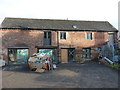
Barn conversions in progress
At the rear (just to the north) of Image, but not listed in its own right, this former cart barn now appears to be in the process of conversion to residential use.
Image: © Richard Law
Taken: 3 Dec 2017
0.10 miles
3
The former Bell Inn, Alveley
Grade II* listed https://www.britishlistedbuildings.co.uk/101367871-the-bell-inn-alveley#.WixLW9SLTGg in 1974, at which time it was still a public house, this is now a private residence, having closed some 25 years or so ago. In itself it dates mainly from the 17th century, but its II* listing is primarily given for the remarkable amount of 12th & 13th century stonework and carvings that have been found in and around the structure. These include several large interlace panels, and a coffin lid, most of which are thought likely to have come from the nearby parish church at some stage.
Image: © Richard Law
Taken: 3 Dec 2017
0.10 miles
4
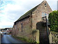
Former malthouse, Alveley
This Grade II listed https://www.britishlistedbuildings.co.uk/101254267-outbuilding-and-attached-wall-to-north-west-of-number-6-the-bell-inn-alveley#.WixJzNSLTGg 18th century sandstone building is described as a probable former malthouse, as it is adjacent to the Image, which lies behind it and is now a private house.
Image: © Richard Law
Taken: 3 Dec 2017
0.11 miles
5
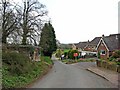
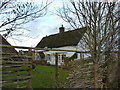
Minor road to the Buttercross
This road forms a long loop that leads back to the village, serving various farms and houses on its route. It also passes the well-known Buttercross, about two miles out of the village.
Image
Image: © P L Chadwick
Taken: 18 Apr 2010
0.12 miles
6
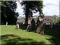
Churchyard View
The view from the churchyard of St Mary the Virgin, Alveley. The gravestones dated back from 1635.
Image: © Gordon Griffiths
Taken: 3 Aug 2013
0.12 miles
7
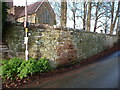
Sandstone walls on the east side of the churchyard
The walls that surround the churchyard were Grade II listed https://www.britishlistedbuildings.co.uk/101053192-churchyard-walls-alveley#.Wi1sBNSLTGg in 1974; they are built of irregularly-coursed sandstone rubble with a rounded stone coping.
Image: © Richard Law
Taken: 3 Dec 2017
0.13 miles
8
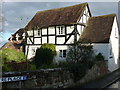
7 Centre Place, Alveley
Another of several attractive Grade II listed https://www.britishlistedbuildings.co.uk/101367872-7-centre-place-alveley#.WixIgtSLTGg properties in the middle of the village; this dates from the 17th century and is described in its listing details as 'unoccupied' in 1970. That's clearly no longer the case.
Image: © Richard Law
Taken: 3 Dec 2017
0.13 miles
9
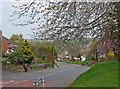
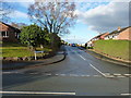
Daddlebrook Road near its junction with Church Road
The quaintly named Daddlebrook Road is a long road traversing the newer part of the village of Alveley, which for a few decades in the 20th century was a mining village. This part of the road is near its junction with the main road in the older part of the village. The orange signs, which can be glimpsed in the distance, are posters for the local Liberal Democrat candidate in the 2010 General Election.
Image: © P L Chadwick
Taken: 18 Apr 2010
0.13 miles
10
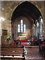
Church Altar
The view in St Mary the Virgin Church in the Shropshire Village of Alveley.
Image: © Gordon Griffiths
Taken: 3 Aug 2013
0.13 miles