IMAGES TAKEN NEAR TO
Canal Road, NEWTOWN, SY16 2JS
Introduction
This page details the photographs taken nearby to Canal Road, SY16 2JS by members of the Geograph project.
The Geograph project started in 2005 with the aim of publishing, organising and preserving representative images for every square kilometre of Great Britain, Ireland and the Isle of Man.

There are currently over 7.5m images from over14,400 individuals and you can help contribute to the project by visiting https://www.geograph.org.uk
Image Map
Images are licensed for reuse under creativecommons.org/licenses/by-sa/2.0
Notes
- Clicking on the map will re-center to the selected point.
- The higher the marker number, the further away the image location is from the centre of the postcode.
Image Listing (178 Images Found)
Images are licensed for reuse under creativecommons.org/licenses/by-sa/2.0
Image
Details
Distance
1
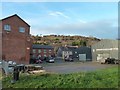
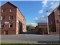
Agricultural supplies yard
Behind the apartment block of the converted Cymric Mill building (left) and the adjoining cottages is the yard of Roberts & Bumford, Agricultural Merchants. Standing on the site of the Montgomery Canal which terminated in a basin about 300m SW of here.
Half way up the hill beyond are houses on Hillside Avenue and, at the top, houses in Poplar Close on the Barnfields estate.
Image: © Penny Mayes
Taken: 2 Dec 2017
0.01 miles
2
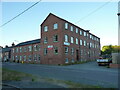
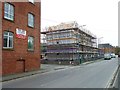
Cymric Mill on Lower Canal Road
One of the remaining former tweed mills of Newtown, which was converted to flats several years ago. The former millworkers' houses to the left were restored around the same time. Beyond those lies the quite imposing Image of the late 19th century.
Image: © Richard Law
Taken: 9 Jul 2022
0.01 miles
3
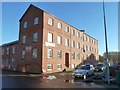
Cymric Mill
Once a flannel mill, it has been converted into residential apartments. It stands between Canal Road and the River Severn on the eastern outskirts of Newtown.
The Montgomery Canal used to lie between the mill and the river, terminating in a basin to the SW. The empty plot to the left of the building is the site of the much larger Commercial Mill.
Image: © Penny Mayes
Taken: 25 Dec 2008
0.02 miles
4
Cymric Mill during the building of Cwrt Cei Coed
This former tweed mill was converted into flats some years ago. The houses on the left are part of the original mill and were built at the same time, possibly to house workers.
It used to back onto the canal but that was filled in long ago. The roadway beside it does provide access over the flood defences to the river.
Photos of the building of Cwrt Cei Coed on the adjacent plot may be found here https://www.geograph.org.uk/snippet/18420
Image: © Penny Mayes
Taken: 1 Jan 2018
0.02 miles
5
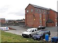
Access to the river
Between Cymric Mill apartments (left) and the new Cwrt Cei Coed development http://www.geograph.org.uk/snippet/18420 (right). This road also gives access to Roberts & Bumford, Agricultural Merchants http://www.geograph.org.uk/photo/5955310.
The building among the trees in the background is across the river on Kirkhamsfield council road maintenance depot.
Image: © Penny Mayes
Taken: 29 Oct 2018
0.03 miles
6
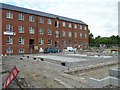
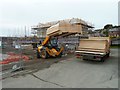
New housing development on Lower Canal Road - August, 2017
On the site of Commercial (or Kymric) tweed mill which closed in 1935. It was used by the Ministry of Supply as a food depot during WWII and, more recently was the site of the Price & Orphin engineering works where they manufactured parts for aircraft and racing-cars.
The site was cleared more than 10 years ago.
Image: © Penny Mayes
Taken: 12 Aug 2017
0.03 miles
7
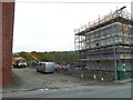
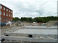
New housing development on Lower Canal Road - October, 2017
Image: © Penny Mayes
Taken: 20 Oct 2017
0.03 miles
8
New housing development on Lower Canal Road - October, 2017
Image: © Penny Mayes
Taken: 20 Oct 2017
0.03 miles
9
New housing development on Lower Canal Road - October, 2017
Image: © Penny Mayes
Taken: 20 Oct 2017
0.03 miles
10
New housing development on Lower Canal Road - August, 2017
On the site of Commercial (or Kymric) tweed mill which closed in 1935. It was used by the Ministry of Supply as a food depot during WWII and, more recently was the site of the Price & Orphin engineering works where they manufactured parts for aircraft and racing-cars.
The site was cleared more than 10 years ago.
The trees in the background are on the far side of the river.
Image: © Penny Mayes
Taken: 12 Aug 2017
0.03 miles