IMAGES TAKEN NEAR TO
The Causeway, ROMSEY, SO51 8HF
Introduction
This page details the photographs taken nearby to The Causeway, SO51 8HF by members of the Geograph project.
The Geograph project started in 2005 with the aim of publishing, organising and preserving representative images for every square kilometre of Great Britain, Ireland and the Isle of Man.

There are currently over 7.5m images from over14,400 individuals and you can help contribute to the project by visiting https://www.geograph.org.uk
Image Map (Loading...)


Getting Data...Please wait
Leaflet Map data © OpenStreetMap
Images are licensed for reuse under creativecommons.org/licenses/by-sa/2.0
Notes
- Clicking on the map will re-center to the selected point.
- The higher the marker number, the further away the image location is from the centre of the postcode.
Image Listing (67 Images Found)
Images are licensed for reuse under creativecommons.org/licenses/by-sa/2.0
Image
Details
Distance
1
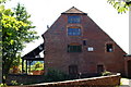
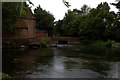
Sadler's Mill, Romsey, Hampshire
Situated by the River Test, a watermill has stood on this site for more than 400 years.
http://en.wikipedia.org/wiki/Sadler's_Mil
Image
Image: © Peter Trimming
Taken: 17 Jun 2010
0.00 miles
2
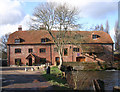
Sadler's Mill, The Causeway, Romsey SO51 8HF
Sadler's Mill on the Test Way. Rebuilt by the first Lord Palmerston in 1748 and restored over the past three years. The Test Way access is opposite the white bollards in the photograph. The Mill is generally referred to as Saddlers Mill with two D's this is incorrect. The name arose from Richard Sadler who is to be found in the Hearth Tax returns of 1665. Reference LTVAS Group publication 'Romsey Mills and Waterways'.
Image: © Ray Lambert
Taken: 6 Feb 2008
0.01 miles
3
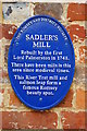
Plaque on Sadler's Mill, Romsey, Hampshire
The plaque gives some detail about the mill's history.
http://en.wikipedia.org/wiki/Sadler's_Mil
Image
Image: © Peter Trimming
Taken: 17 Jun 2010
0.01 miles
4
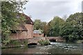
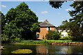
Sadler's Mill on the River Test
18th century mill building (with evidence for an earlier, 17th century structure) https://en.wikipedia.org/wiki/Sadler%27s_Mill . Now in residential use.
Image: © Tim Heaton
Taken: 11 Oct 2023
0.02 miles
6
View Across the River Test, Romsey, Hampshire
View from beside Sadler's Mill.
Image: © Peter Trimming
Taken: 17 Jun 2010
0.03 miles
7
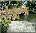
Romsey - Sadler's Mill Bridge
Bridge across the River Test at historic Sadler's Mill.
Image: © Colin Smith
Taken: 17 Jul 2021
0.03 miles
8
Water beyond flood defence bank, Sadler's Mill
Image: © David Martin
Taken: 3 Nov 2023
0.04 miles
9
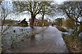
Floodwater beside the River Test
In this remarkable scene, water is pouring across the lane from the flooded meadows to the left and re-entering the main channel of the River Test, which has just come down through the sluices at Sadlers Mill. The summer scene Image shows the lane and mill building from somewhere adjacent to the first house in this image and Image shows new flood defences, completed in 2022.
Image: © David Martin
Taken: 8 Feb 2014
0.05 miles
10
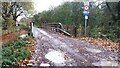
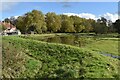
Flood defences on The Causeway, Romsey
This bridge is part of a new flood alleviation scheme, opened July 2022, and permits floodwater to pass under The Causeway into the River Test. Compare Image at almost the same spot.
Image: © David Martin
Taken: 7 Nov 2022
0.06 miles