IMAGES TAKEN NEAR TO
Kimbridge, ROMSEY, SO51 0LE
Introduction
This page details the photographs taken nearby to SO51 0LE by members of the Geograph project.
The Geograph project started in 2005 with the aim of publishing, organising and preserving representative images for every square kilometre of Great Britain, Ireland and the Isle of Man.

There are currently over 7.5m images from over14,400 individuals and you can help contribute to the project by visiting https://www.geograph.org.uk
Image Map (Loading...)


Getting Data...Please wait
Leaflet Map data © OpenStreetMap
Images are licensed for reuse under creativecommons.org/licenses/by-sa/2.0
Notes
- Clicking on the map will re-center to the selected point.
- The higher the marker number, the further away the image location is from the centre of the postcode.
Image Listing (30 Images Found)
Images are licensed for reuse under creativecommons.org/licenses/by-sa/2.0
Image
Details
Distance
1
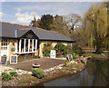
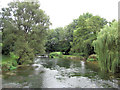
River Test at Kimbridge
Kimbridge Lane crosses the Test here, giving a good view of one of the country's most famous trout fishing rivers.
Image: © Patrick Pavey
Taken: 5 Jan 2007
0.02 miles
2
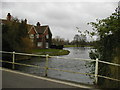
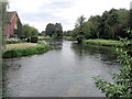
River Test in January, above the sluices
The Test runs under the road, held back by sluice gates on one side, but gushing forth on the other. Image was shot from almost the same spot, facing in the opposite direction
Image: © Rosemary Oakeshott
Taken: 29 Jan 2008
0.03 miles
3

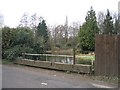
Bridge over the Test at Kimbridge
The last, and widest, of a series of narrow bridges on the approach to the level crossing. the level crossing
Image: © Rosemary Oakeshott
Taken: 7 Nov 2007
0.04 miles
4
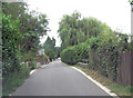
Kimbridge Lane crosses the River Test
The lane crosses a complex of channels, emanating from the adjacent trout farm which sits beside the River Test, before bridging the main watercourse.
Image: © Stuart Logan
Taken: 11 Sep 2013
0.04 miles
5
River Test at Kimbridge - looking upstream
Under leaden skies the sparkling waters of the river look dark but make no mistake, this is some of the best trout-fishing water in the world. The river is 40 miles in length and more detail can be found at: http://en.wikipedia.org/wiki/River_Test
Image: © Stuart Logan
Taken: 11 Sep 2013
0.05 miles
6
River Test at Kimbridge - looking downstream
Under leaden skies the sparkling waters of the river look dark but make no mistake, this is some of the best trout-fishing water in the world. The river is 40 miles in length and more detail can be found at: http://en.wikipedia.org/wiki/River_Test
Image: © Stuart Logan
Taken: 11 Sep 2013
0.05 miles
7
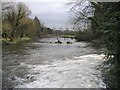
River Test in January, below the sluices
This image was taken from the same bridge as Image but it shows a very different river, with the water gushing out of the sluices and the absence of greenery on the banks making the river look much wider.
Image: © Rosemary Oakeshott
Taken: 29 Jan 2008
0.09 miles
8
House sign and bench mark, Kimbridge
For a wider view of the house Image
Image: © Maigheach-gheal
Taken: 29 May 2011
0.09 miles
9
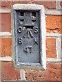
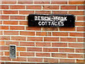
Flush Bracket 47, Bench Mark Cottages
Flush bracket 47 is to be found on No 1. Bench Mark Cottages. For a view of the cottages Image and for further information on the flush bracket and others in the area http://www.bench-marks.org.uk/bm1565
Image: © Maigheach-gheal
Taken: 29 May 2011
0.10 miles