IMAGES TAKEN NEAR TO
Streamdale, LONDON, SE2 0PD
Introduction
This page details the photographs taken nearby to Streamdale, SE2 0PD by members of the Geograph project.
The Geograph project started in 2005 with the aim of publishing, organising and preserving representative images for every square kilometre of Great Britain, Ireland and the Isle of Man.

There are currently over 7.5m images from over14,400 individuals and you can help contribute to the project by visiting https://www.geograph.org.uk
Image Map
Images are licensed for reuse under creativecommons.org/licenses/by-sa/2.0
Notes
- Clicking on the map will re-center to the selected point.
- The higher the marker number, the further away the image location is from the centre of the postcode.
Image Listing (133 Images Found)
Images are licensed for reuse under creativecommons.org/licenses/by-sa/2.0
Image
Details
Distance
1
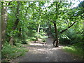
Path in Bostall Woods
This path follows around the base of the steep western slope of Bostall Woods.
Image: © Marathon
Taken: 13 Jun 2020
0.03 miles
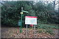
2
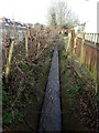
The 'Lost' River Wogebourne
The River Wogebourne rose on the slopes of Shooters Hill, ran across what is now Woodlands Farm and East Wickham Open Space before turning north along the Wickham Valley. It is seen here flowing downstream from Streamway. Not only the river lives on but in the road names of Streamway, Woodbrook Road, Bournewood Road and Waterdale Road, all in this small area.
A full history of the Wogebourne can be seen at http://e-shootershill.co.uk/2013/09/08/wogebourne/
Image: © Marathon
Taken: 31 Jan 2021
0.03 miles
3
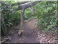
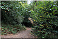
Path in Bostall Woods
This path follows around the base of the steep western slope of Bostall Woods. This tree has fallen to give two alternative ways past.
Image: © Marathon
Taken: 30 Apr 2020
0.07 miles
4
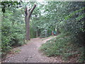
Green Chain Walk in Bostall Woods
The long distance path leads from Longleigh Lane through the wood towards Cemetery Road, near East Wickham Cemetery.
Image: © David Anstiss
Taken: 7 Aug 2011
0.08 miles
6
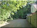
The Green Chain Walk entering Bostall Woods
Cemetery Road turns sharp left just past the entrance to Plumstead Cemetery and becomes more of a rough track here on the way to Bostall Woods, the entrance of which is just ahead. The house on the right belongs to Plumstead Cemetery.
Image: © Marathon
Taken: 25 May 2020
0.09 miles
8
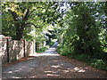
Cemetery Road, Plumstead
Looking back from the dead end (no pun intended) with the cemetery on the left.
Image: © Stephen Craven
Taken: 23 Aug 2009
0.10 miles
9
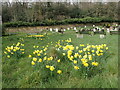
Daffodils in Plumstead Cemetery
The site now occupied by Plumstead Cemetery was formerly parkland that was laid out during the 17th century. The land was owned by Old Park Farm in 1845. Plumstead Cemetery was opened by Woolwich Burial Board in 1890. It occupies a prominent hillside and is backed to the north by Bostall Woods as can be seen here.
Image: © Marathon
Taken: 1 Apr 2021
0.10 miles
10
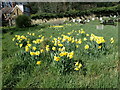
Daffodils in Plumstead Cemetery
The site now occupied by Plumstead Cemetery was formerly parkland that was laid out during the 17th century. The land was owned by Old Park Farm in 1845. Plumstead Cemetery was opened by Woolwich Burial Board in 1890. It occupies a prominent hillside and is backed to the north by Bostall Woods as can be seen here.
Image: © Marathon
Taken: 5 Apr 2021
0.10 miles