IMAGES TAKEN NEAR TO
Highland Road, LONDON, SE19 1DW
Introduction
This page details the photographs taken nearby to Highland Road, SE19 1DW by members of the Geograph project.
The Geograph project started in 2005 with the aim of publishing, organising and preserving representative images for every square kilometre of Great Britain, Ireland and the Isle of Man.

There are currently over 7.5m images from over14,400 individuals and you can help contribute to the project by visiting https://www.geograph.org.uk
Image Map
Images are licensed for reuse under creativecommons.org/licenses/by-sa/2.0
Notes
- Clicking on the map will re-center to the selected point.
- The higher the marker number, the further away the image location is from the centre of the postcode.
Image Listing (335 Images Found)
Images are licensed for reuse under creativecommons.org/licenses/by-sa/2.0
Image
Details
Distance
1
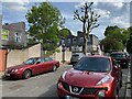
South and uphill on Vicar's Oak Road, Crystal Palace
Image: © Robin Stott
Taken: 19 May 2022
0.02 miles
2
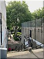
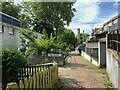
Central Hill estate ? steps by the disused boiler house
The steps connect Highland Road, behind the camera, with Plane Tree Walk.
Image: © Robin Stott
Taken: 19 May 2022
0.02 miles
3
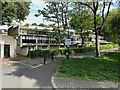
Central Hill estate ? Plane Tree Walk 2-24
Ground-zero on the west-facing sunny side of the estate. The terraces below Central Hill itself are northeast-facing though they have a sunny outlook.
Image: © Robin Stott
Taken: 19 May 2022
0.03 miles
4
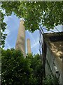
Central Hill estate ? boiler house chimneys near Plane Tree Walk
The boiler house, which originally supplied district heating to the estate (by burning waste, according to Open Street Map), is no longer used. The chimneys are a local landmark Image
Image: © Robin Stott
Taken: 19 May 2022
0.04 miles
5
Central Hill estate ? Plane Tree Walk and boiler house
Boiler House is an assumption. The estate had district heating originally but it is no longer used.
Image: © Robin Stott
Taken: 19 May 2022
0.04 miles
6
Central Hill Estate, SE19: Vicars Oak Road
Five London Boroughs meet on the hill at Upper Norwood, reflecting an earlier meeting of five parishes: the point at which the parish boundaries met, some few hundred yards east of this estate, was marked by a tree known as the Vicar's Oak, to which this street name nods.
Image: © Christopher Hilton
Taken: 22 Apr 2016
0.04 miles
7
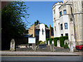
Gipsy Hill: All Saints Church
Showing the modern part of the church. The tower is to the right, see Image
Image: © Dr Neil Clifton
Taken: 26 Jul 2012
0.04 miles
8
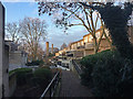
Central Hill Estate, Lunham Road
Plane Tree Walk in weak late afternoon sunshine. The estate was put up by Lambeth Council in 1967-74 (in the days when local authorities employed architects and built public housing). Pevsner comments that it is "stylistically still very much in the International Modern tradition...with ingenious planning it was possible to give all the flats front doors at ground level, reached by paths along the contours of the hill". Many flats have excellent views towards central London.
Despite all that, in what is becoming a sadly familiar tale, Lambeth wants to demolish all 450 homes on the estate so that it can build private ones, the sale of which will fund new social housing. Residents seem to oppose the plan, presumably because they will be scattered to the four winds. A Twentieth Century Society bid to have the estate listed failed.
Image: © Stephen Richards
Taken: 14 Dec 2018
0.04 miles
9
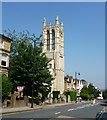
Gipsy Hill: Tower of Christ Church
Only the tower remains of the original ragstone church, the rest having been replaced by modern accommodation.
Image: © Dr Neil Clifton
Taken: 26 Jul 2012
0.04 miles
10
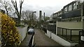
Central Hill estate ? north on Plane Tree Walk
Plane Tree Walk slopes gently down to Lunham Road. The ramp to the right takes people up to Vicar's Oak Road and on up to buses and shops. In the distance are the chimneys of the boiler house that might be called an incinerator. No longer used, it burnt waste to provide district heating.
Image: © Robin Stott
Taken: 19 May 2022
0.05 miles