IMAGES TAKEN NEAR TO
Ledsham Court, BARNSLEY, S74 8BD
Introduction
This page details the photographs taken nearby to Ledsham Court, S74 8BD by members of the Geograph project.
The Geograph project started in 2005 with the aim of publishing, organising and preserving representative images for every square kilometre of Great Britain, Ireland and the Isle of Man.

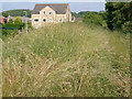
There are currently over 7.5m images from over14,400 individuals and you can help contribute to the project by visiting https://www.geograph.org.uk
Image Map
Images are licensed for reuse under creativecommons.org/licenses/by-sa/2.0
Notes
- Clicking on the map will re-center to the selected point.
- The higher the marker number, the further away the image location is from the centre of the postcode.
Image Listing (14 Images Found)
Images are licensed for reuse under creativecommons.org/licenses/by-sa/2.0
Image
Details
Distance
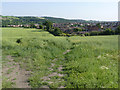
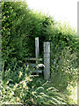
1
Footpath and kissing gate
The edge of the housing estate on the north side of Elsecar.
Image: © Alan Murray-Rust
Taken: 8 Jul 2013
0.03 miles
2
Footpath below Low Farm
Compared with its neighbour http://www.geograph.org.uk/photo/3549914 this path appears to be more heavily used and retains a more distinct line through the rape crop.
Image: © Alan Murray-Rust
Taken: 8 Jul 2013
0.07 miles
3
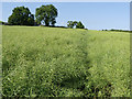
Footpath below Low Farm
Well-developed rape crops are never conducive to maintaining a good footpath.
Image: © Alan Murray-Rust
Taken: 8 Jul 2013
0.08 miles
4
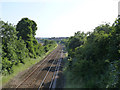
Midland Railway Chapeltown Extension Railway
Looking south from the bridge carrying the lane to Low Farm. The line was built as late as 1893-95 to tap the expanding coal industry in the Barnsley area.
Image: © Alan Murray-Rust
Taken: 8 Jul 2013
0.10 miles
5
Stile near Low Farm
The footpath beyond the stile is clearly only used occasionally - it is nearly overgrown with nettles, brambles and other less tiresome plants! Given the current state of the footpath behind the photographer http://www.geograph.org.uk/photo/3549914 and the existence of an easier alternative to the west of Low Farm, the lack of use is hardly surprising!
Image: © Alan Murray-Rust
Taken: 8 Jul 2013
0.11 miles
6
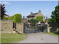
Low Farm
Shown as Hemingfield Farm on the 1:25000 map. The farm outbuildings have all been converted to residential use.
Image: © Alan Murray-Rust
Taken: 8 Jul 2013
0.11 miles
7
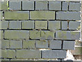
Bench Mark, Cemetery Road railway bridge, Hemingfield
Cut bench mark in the parapet of the bridge http://www.geograph.org.uk/photo/3549901 .
Image: © Alan Murray-Rust
Taken: 8 Jul 2013
0.20 miles
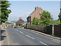
8
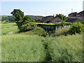
Bridge over railway line to Sheffield.
Image: © Steve Fareham
Taken: 11 Sep 2007
0.21 miles
9
Overgrown footpath
The straight alignment of the footpath to the right of the picture is the result of it following the line of the old incline. Most people now probably use the new footpaths through the housing estate, marked by the lighting columns.
Image: © Alan Murray-Rust
Taken: 8 Jul 2013
0.21 miles
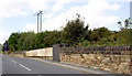
10
Cemetery Road railway bridge, Hemingfield
There is a bench mark cut into the parapet on the right hand side at this end of the bridge http://www.geograph.org.uk/photo/3549895 .
Image: © Alan Murray-Rust
Taken: 8 Jul 2013
0.21 miles