IMAGES TAKEN NEAR TO
Ditchling Road, HAYWARDS HEATH, RH16 4QU
Introduction
This page details the photographs taken nearby to Ditchling Road, RH16 4QU by members of the Geograph project.
The Geograph project started in 2005 with the aim of publishing, organising and preserving representative images for every square kilometre of Great Britain, Ireland and the Isle of Man.

There are currently over 7.5m images from over14,400 individuals and you can help contribute to the project by visiting https://www.geograph.org.uk
Image Map
Images are licensed for reuse under creativecommons.org/licenses/by-sa/2.0
Notes
- Clicking on the map will re-center to the selected point.
- The higher the marker number, the further away the image location is from the centre of the postcode.
Image Listing (34 Images Found)
Images are licensed for reuse under creativecommons.org/licenses/by-sa/2.0
Image
Details
Distance
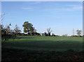
1
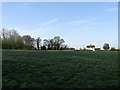
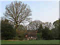
Lunce's Common
The only registered common in the parish as well as the last surviving one from the middle ages. The common includes this open ground as well as an area of wood containing an old quarry to the south. Griggs Cottage is the two storey building on the right with Studio Cottage to the left.
Image: © Simon Carey
Taken: 10 Apr 2011
0.04 miles
2
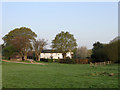
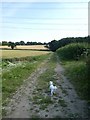
Rogers Farm
Located on the edge of Lunce's Common. The farm dates back to the 12th or 13th century though the current farmhouse in view was constructed in the early 19th. An older 17th century barn still stands to the rear.
Image: © Simon Carey
Taken: 17 Apr 2011
0.04 miles
3
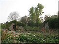
The Griggs
The ruins of a former farm lie next to the footpath that links Lunce's Common to Wivelsfield.
Image: © Simon Carey
Taken: 17 Apr 2011
0.04 miles
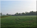
4
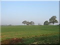
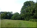
Long Meadow/Long Field
The name of the fields according to Wivelsfield's 1843 tithe map that have been joined together along with Image to form a large modern field. Long Field was next to the hedgerow trees in the distance, Long Meadow further down the slope.
Image: © Simon Carey
Taken: 17 Apr 2011
0.07 miles
5
The Olde Cottage
A classic example of a cottage built on the edge of a common. Built in the late 16th century with rights to use Lunce's Common which include not only grazing animals but also the use of gorse, furze, underwood and peat.
Image: © Simon Carey
Taken: 17 Apr 2011
0.08 miles
8
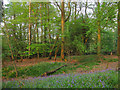
Lunce's Common
The last remaining common in the parish of Wivelsfield. This is the southern section that has been left alone from grazing to become woodland. Much like Chailey there are ridges to the south which mark the centuries old routes of cattle entering and exit the common. There are also pits, the common was to contain sandstone which was duly excavated to provide materials for nearby houses, a gravel pit to the north was known to provide material for the old turnpike, now the B2112.
Image: © Simon Carey
Taken: 17 Apr 2011
0.11 miles
9
Wood Field/Pond Field
The name of the fields according to Wivelsfield's 1843 tithe map that have been joined together to make a larger unit. Wood Field was in the foreground and referred to the former Church Wood which lay immediately to the south, whilst Pond Field was situated towards the far end of the current field with Image just visible on the left.
Image: © Simon Carey
Taken: 17 Apr 2011
0.12 miles
10
House Meadow/Three Acre Field
The name of the fields according to Wivelsfield's 1843 tithe map that have been joined together to form a larger unit. House Meadow was in the foreground. Three Acre Field further on. The buildings on the left belong to Rogers Farm.
Image: © Simon Carey
Taken: 10 Apr 2011
0.12 miles