IMAGES TAKEN NEAR TO
Ashes Lane, ROCHDALE, OL16 3TN
Introduction
This page details the photographs taken nearby to Ashes Lane, OL16 3TN by members of the Geograph project.
The Geograph project started in 2005 with the aim of publishing, organising and preserving representative images for every square kilometre of Great Britain, Ireland and the Isle of Man.

There are currently over 7.5m images from over14,400 individuals and you can help contribute to the project by visiting https://www.geograph.org.uk
Image Map
Images are licensed for reuse under creativecommons.org/licenses/by-sa/2.0
Notes
- Clicking on the map will re-center to the selected point.
- The higher the marker number, the further away the image location is from the centre of the postcode.
Image Listing (70 Images Found)
Images are licensed for reuse under creativecommons.org/licenses/by-sa/2.0
Image
Details
Distance
1
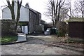
Ashes Fold
Old buildings on the periphery of Ashes farm land used for housing in the 1970s.
Image: © Bryan Tenny
Taken: 17 Feb 2011
0.02 miles
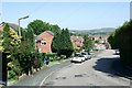
2
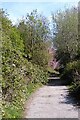
Halliwell Street
This road stretching from Bridge St to Uncouth Rd unmade up for much of its length has been closed to through traffic for a long time. The unmade up section is still open for pedestrians, cycles and as a bridleway. Encroaching vegetation has made it into a pleasant walk.
Image: © Bryan Tenny
Taken: 17 Apr 2020
0.04 miles
3
Roads Ford Avenue
Part of the 1970s housing estate built on the site of Ashes farm.
Image: © Bryan Tenny
Taken: 17 Feb 2011
0.05 miles
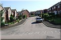
4
Stock Grove towards Weir Road
Another view of Stock Grove. Part of a 1970s housing estate in Milnrow.
Image: © Bryan Tenny
Taken: 19 Apr 2011
0.05 miles
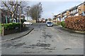
5
Weir Road
Weir Road is a no through road. Part of a 1970s/80s housing estate in Milnrow, the road has two bends. This view is taken down the hill from the upper bend.
Image: © Bryan Tenny
Taken: 19 Apr 2011
0.05 miles
6
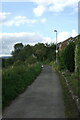
Ashes Lane
Ashes Lane is a mix of paved and unpaved surfaces leading from Kiln Lane down into the beal Valley where it joins an access road to the former Milnrow sewage works.
Once past Ashes farm it becomes more of a path or bridleway with vegetation and trees encroaching from both sides.
Image: © Bryan Tenny
Taken: 29 Sep 2020
0.05 miles
7
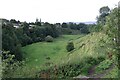
The Beal Valley
Viewed from Ashes Lane, the Beal Valley contains the River Beal, a tributary of the Roch, which is itself a tributary of the River Irwell.
Image: © Bryan Tenny
Taken: 29 Sep 2020
0.05 miles
8
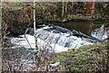
River Beal Weir
The weir on the river Beal in Milnrow from which Weir Rd in the 1970s housing estate on the site of Ashes farm takes its name.
Image: © Bryan Tenny
Taken: 17 Jan 2011
0.06 miles
9
Stock Grove from Weir Road
Part of a late 1970s housing development in Milnrow.
Image: © Bryan Tenny
Taken: 19 Apr 2011
0.06 miles
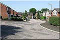
10
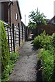
Alley to Croft Head Drive
This alley runs from Stock Grove to Croft Head Drive on the 1970s Ashes Farm estate in Milnrow
Image: © Bryan Tenny
Taken: Unknown
0.07 miles