IMAGES TAKEN NEAR TO
Endor Road, MANSFIELD, NG18 6BH
Introduction
This page details the photographs taken nearby to Endor Road, NG18 6BH by members of the Geograph project.
The Geograph project started in 2005 with the aim of publishing, organising and preserving representative images for every square kilometre of Great Britain, Ireland and the Isle of Man.

There are currently over 7.5m images from over14,400 individuals and you can help contribute to the project by visiting https://www.geograph.org.uk
Image Map
Images are licensed for reuse under creativecommons.org/licenses/by-sa/2.0
Notes
- Clicking on the map will re-center to the selected point.
- The higher the marker number, the further away the image location is from the centre of the postcode.
Image Listing (17 Images Found)
Images are licensed for reuse under creativecommons.org/licenses/by-sa/2.0
Image
Details
Distance
1
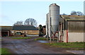
Black Scotch Lane, Mansfield, Notts.
The entrance to Firs Farm at the side of the southern section of Black Scotch Lane, i.e. south of the A617, a road that bisects this lane about 50 yards to the left.
Image: © David Hallam-Jones
Taken: 11 Jan 2015
0.04 miles
2
Black Scotch Lane, Mansfield, Notts.
Firs Farm is seen here from the south section of Black Scotch Lane, i.e. the part of Black Scotch Lane south of the A617, a road that has for a number of years (number unknown) bisected this lane 150 yards ahead.
Image: © David Hallam-Jones
Taken: 11 Jan 2015
0.05 miles
3
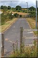
Black Scotch Lane
Track heading north from the A617.
Image: © JThomas
Taken: 17 Mar 2014
0.10 miles
4
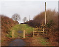
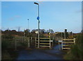
Black Scotch Lane, Mansfield, Notts.
The path and bridleway ahead leads users past Firs Farm and terminates when it reaches a T junction with a footpath that follows the course of the Old Newark Road. These bollards obviously exist to prevent most motor vehicles from entering or exiting this southern section of Black Scotch Lane. The northern section of the lane continues behind the photographer on the other side of the A617 road.
Image: © David Hallam-Jones
Taken: 11 Jan 2015
0.12 miles
5
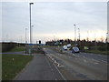
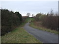
A617 approaching roundabout
Heading east towards Newark.
Image: © JThomas
Taken: 17 Mar 2014
0.13 miles
6
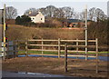
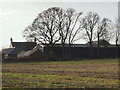
Firs Farm Vicinity, Mansfield, Notts.
A pedestrian and bridleway island in the middle of the A617 road allowing not motorised users to cross from the northern to the southern section of Black Scotch Lane - and vice versa - in safety. Firs Farm is evident in the distance.
Image: © David Hallam-Jones
Taken: 11 Jan 2015
0.13 miles
7
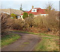
Black Scotch Lane, Mansfield, Notts.
The view from the rear dormer window of this house in Chatsworth Drive might include this T junction. The shaft of the letter T is the southern-most part of Black Scotch Lane, whereas the horizontal bar of the T is a track following the course of the Old Newark Road.
Image: © David Hallam-Jones
Taken: 11 Jan 2015
0.13 miles
8
Firs Farm Vicinity, Mansfield, Notts.
A pedestrian and bridleway entrance/exit that allows users to cross the A617 road from the northern to the southern section of Black Scotch Lane - and vice versa - now that A617 has bisected this farm lane (new road opened in late 2004). Firs Farm is evident in the distance. A footpath following the route of the Old Newark Road can be reached on the other side of this road following a 15 minute walk ahead.
Image: © David Hallam-Jones
Taken: 11 Jan 2015
0.14 miles
9
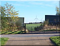
Old Newark Road, Mansfield, Notts.
On the other side of the A6117 dual carriageway (a.k.a. Adamsway), between the high fences, a surfaced footpath leads 150 yds downhill until it reaches the south-westerly edge of the Bellamy Road (residential) Estate and a mile long properly-maintained stretch of the former Old Newark Road (still called Old Newark Road). The eastern section of the former Old Newark Road, on this side of the road, gives the impression of being maintained in a usable condition however, within 50 yds the route resorts to being a rough-and-ready track that is only suitable for mountain bikers, pedestrians and horses-riders. The Lindhurst Wind Farm can is also visible in the distance.
Image: © David Hallam-Jones
Taken: 10 Nov 2013
0.15 miles