IMAGES TAKEN NEAR TO
Kirkdale Gardens, NOTTINGHAM, NG10 3JA
Introduction
This page details the photographs taken nearby to Kirkdale Gardens, NG10 3JA by members of the Geograph project.
The Geograph project started in 2005 with the aim of publishing, organising and preserving representative images for every square kilometre of Great Britain, Ireland and the Isle of Man.

There are currently over 7.5m images from over14,400 individuals and you can help contribute to the project by visiting https://www.geograph.org.uk
Image Map
Images are licensed for reuse under creativecommons.org/licenses/by-sa/2.0
Notes
- Clicking on the map will re-center to the selected point.
- The higher the marker number, the further away the image location is from the centre of the postcode.
Image Listing (14 Images Found)
Images are licensed for reuse under creativecommons.org/licenses/by-sa/2.0
Image
Details
Distance
1
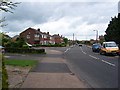
Ruskin Avenue/Ribblesdale Road junction
This shows the main spine of the estate that was the first to be developed in the latter half of the 20th century. Newer properties have since been built off Ribblesdale Road to the left.
Image: © Garth Newton
Taken: 18 May 2006
0.08 miles
2
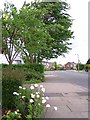
Ruskin Avenue
In the 1940s there were a number of roads only about 100 yards long, off Wilsthorpe Road. Since then the M1 motorway has been constructed to the west and in the latter half of the last century those short roads were extended and linked resulting in a large housing estate now filling the intervening area. Trees and flowers in the gardens are now softening the landscape and giving the estate a more mature feel.
Image: © Garth Newton
Taken: 18 May 2006
0.14 miles
3
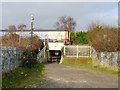
Railway underpass and former level crossing
The gateway used to lead to a level crossing. An East Midlands Trains DMU is passing over the top.
Image: © Ian Calderwood
Taken: 7 Dec 2016
0.17 miles
4
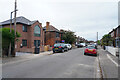
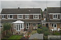
Carlton Road
The first house on the left seems to have had a very good extension or redesign, with the huge triangular topped window above the main entrance.
Image: © Malcolm Neal
Taken: 17 Jun 2021
0.18 miles
5
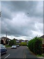
Under the flight path
The new housing estate that has been developed in the latter half of the last century is frequently crossed by aircraft from the Nottingham East Midlands Airport at Castle Donington which is only a few miles away.
Image: © Garth Newton
Taken: 18 May 2006
0.19 miles
6
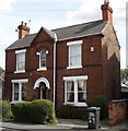
House on Ruskin Avenue, New Sawley
New Sawley is sandwiched between the railway line, the M1 motorway, and the B6002 (Wilsthorpe Road). This attractive older house is typical of the houses closer to the main road (Wilsthorpe Road); further along the road (towards the motorway) the housing is much more modern.
Image: © Oxymoron
Taken: 15 Aug 2008
0.19 miles
7
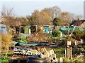
Wilmot Street Allotments
The allotments have been here since the 19th century and, therefore, pre-date Wilmot Street, which wasn't built 'til the mid-20th.
Image: © Ian Calderwood
Taken: 7 Dec 2016
0.20 miles
9
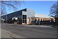
Recently vacated offices
What looks like an old mill building on Wilsthorpe Road given a modern face-lift, was until last year occupied by a computer consultancy. Currently empty, though the companies occupying the rear of the building are still trading
Image: © David Lally
Taken: 10 Feb 2008
0.22 miles
10
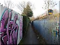
Footpath by the railway
This was originally a field path to Sawley but urbanisation and diversions have left it hemmed-in and subject to vandalism and anti-social behaviour.
Image: © Ian Calderwood
Taken: 7 Dec 2016
0.22 miles