IMAGES TAKEN NEAR TO
Scocles Road, SHEERNESS, ME12 3RU
Introduction
This page details the photographs taken nearby to Scocles Road, ME12 3RU by members of the Geograph project.
The Geograph project started in 2005 with the aim of publishing, organising and preserving representative images for every square kilometre of Great Britain, Ireland and the Isle of Man.

There are currently over 7.5m images from over14,400 individuals and you can help contribute to the project by visiting https://www.geograph.org.uk
Image Map (Loading...)


Getting Data...Please wait
Leaflet Map data © OpenStreetMap
Images are licensed for reuse under creativecommons.org/licenses/by-sa/2.0
Notes
- Clicking on the map will re-center to the selected point.
- The higher the marker number, the further away the image location is from the centre of the postcode.
Image Listing (21 Images Found)
Images are licensed for reuse under creativecommons.org/licenses/by-sa/2.0
Image
Details
Distance
1
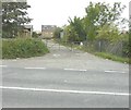
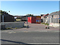
Derelict buildings, Scocles Farm, Scocles Road
A planning application (seen here attached to the gate), reference SW/12/1311, was made through Swale Borough Council for “redevelopment of redundant farm buildings and farmyard to provide 21 dwellings including improvement of existing vehicular access”
Image: © John Baker
Taken: 29 Sep 2013
0.07 miles
2
Construction of houses, Scocles Road
Planning permission has been granted by Swale Borough Council under application number SW/12/1311 for the “redevelopment of existing redundant farm buildings including elements of demolition - redevelopment proposals to provide mixed residential development for a total of 19 mixed dwellings of 2 storey and single storey construction together with their associated garages and parking barns and improvement of existing vehicular access”. These Image are those referred to in the application as existing redundant farm buildings.
Image: © John Baker
Taken: 27 Sep 2015
0.10 miles
3
Honeysuckle Drive, Shurland Place
Some houses are still to be built along it.
Image: © John Baker
Taken: 29 Sep 2013
0.10 miles
4
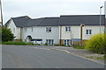
Recently built houses, Scocles Road
The Image has been completed.
Image: © John Baker
Taken: 17 Jan 2017
0.11 miles
5
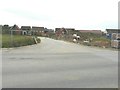
Demolition site, Scocles Road
The entrance to this site can be seen in the view of Image Planning permission has been granted by Swale Borough Council under application number 15/503489/REM as the “approval of reserved matters for the erection of 30 dwellings comprising a mix of detached, semi-detached and terraced houses all with their own amenity space along with provision of landscaping, improvement of existing access, new internal road to service the development, parking and turning and construction of a surface water balance pond (appearance, landscaping and scale being sought). The location given was Sunny View, Scocles Road.
Image: © John Baker
Taken: 27 Sep 2015
0.12 miles
6
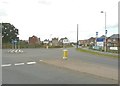
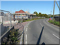
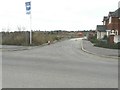
Shurland Place
Is the name of this estate whose blue nameplate can be seen on the right. At this point along Scocles Road, a roundabout has been created to take traffic into the estate along Thistle Hill Way (seen here, straight ahead).
Image: © John Baker
Taken: 22 Aug 2012
0.12 miles
7
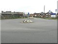
A new look for the entrance to Shurland Place
Seen from Scocles Road, the new houses under construction have hidden part of the view I photographed last year Image
Image: © John Baker
Taken: 29 Sep 2013
0.12 miles
8
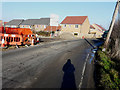
Elm Close, Scocles Road
Planning permission was granted by Swale Borough Council under application number 15/503489/REM as the “approval of reserved matters for the erection of 30 dwellings comprising a mix of detached, semi-detached and terraced houses all with their own amenity space along with provision of landscaping, improvement of existing access, new internal road to service the development, parking and turning and construction of a surface water balance pond (appearance, landscaping and scale being sought)”. The location given was Sunny View, Scocles Road. Before any house construction had started this was a Image
Image: © John Baker
Taken: 17 Jan 2017
0.13 miles
9
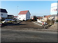
Houses on new development
On the corner of Scocles Road and Queen Anne Close.
Image: © Robin Webster
Taken: 16 May 2018
0.13 miles
10
Crocus Avenue, Shurland Place
There is only a name-plate on the right, so far.
Image: © John Baker
Taken: 29 Sep 2013
0.14 miles