IMAGES TAKEN NEAR TO
Hope Mansell, ROSS-ON-WYE, HR9 5TW
Introduction
This page details the photographs taken nearby to HR9 5TW by members of the Geograph project.
The Geograph project started in 2005 with the aim of publishing, organising and preserving representative images for every square kilometre of Great Britain, Ireland and the Isle of Man.

There are currently over 7.5m images from over14,400 individuals and you can help contribute to the project by visiting https://www.geograph.org.uk
Image Map
Images are licensed for reuse under creativecommons.org/licenses/by-sa/2.0
Notes
- Clicking on the map will re-center to the selected point.
- The higher the marker number, the further away the image location is from the centre of the postcode.
Image Listing (7 Images Found)
Images are licensed for reuse under creativecommons.org/licenses/by-sa/2.0
Image
Details
Distance
1
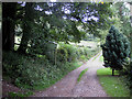
Public footpath to Hom Grove Farm
The track runs close to the dismantled railway line known as Euroclydon/Hawthorns/Puddlebrook, depending on which source of information is used. The line passes through Hom Wood on a steep hillside which is visible on the left of this picture. The Herefordshire/Gloucestershire county border also passes through this woodland.
Image: © Pauline E
Taken: 15 Sep 2010
0.03 miles
2
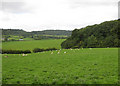
Sheep pastures near Hom Grove Farm
The patch of woodland to the right is the southern tip of Lea Bailey Inclosure.
Image: © Pauline E
Taken: 15 Sep 2010
0.13 miles
3
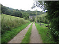
Approaching Hom Grove Farm
The footpath heads SW. At the farm buildings you can either pass through a gate, then swing north towards Hope Mansell, or take a track off to the left then find an unmarked footpath which climbs steeply through Hom Wood and up to Euroclydon on the summit, crossing the trackbed of the dismantled railway.
Image: © Pauline E
Taken: 15 Sep 2010
0.16 miles
4
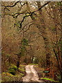
Forestry Commission land
Lea Bailey Inclosure; despite the date of 10th April, this shows the belated spring of 2018.
Image: © Jonathan Billinger
Taken: 10 Apr 2018
0.21 miles
5
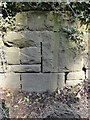
Old Bridge Marker on Hawthorns Road, Hope Mansell
Bridge Marker in the northeast parapet of a bridge on Hawthorns Road over the disused Mitcheldean Road and Forest of Dean Junction Railway. Hope Mansell parish. Inscribed G.W.R. possibly above S D C. The bridge is on a railway line built c.1874 by different contractors for the Mitcheldean Road and Forest of Dean Junction Railway Company. This company was absorbed by the GWR in 1880, who completed the line soon after. The stone is thought to mark the Great Western Railway's ownership of, or responsibility for, the bridge. The vertical groove next to the stone is unexplained but might show where a bridge weight plate, e.g. https://www.geograph.org.uk/photo/6463518, was fixed to the parapet.
Milestone Society National ID: HF_HOPEMA01br
Image: © Roadside Relics
Taken: 26 Mar 2022
0.23 miles
6
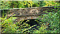
Old railway bridge
The road to Drybrook crosses the Severn and Wye railway which closed to passenger service in 1929.
Image: © Jonathan Billinger
Taken: 11 Oct 2022
0.23 miles
7
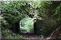
Unused railway bridge, Lea Bailey
I say "unused" rather than "disused" because this line was never opened. The picture shows a bridge carrying the Drybrook road over the course of the old (deep breath) Mitcheldean Road & Forest of Dean Junction Railway (MR&FDJR) which spent all its capital on ink to write down its name before turning to the Great Western Railway for help in completing their line, which was intended to link up the GWR's route from Bullo Pill with the same company's Gloucester-Hereford line at Mitcheldean Road. Anyway, the GWR did indeed finish the line (including this handsome stone bridge), but never opened it for traffic other than a few test trains; the rails on the section north of Drybrook were lifted in 1917 and never relaid. The lengths of rail in the foreground are part of the nearby Lea Bailey Light Railway, a narrow gauge line built on the old formation.
Image: © John Winder
Taken: 24 May 2020
0.24 miles