IMAGES TAKEN NEAR TO
Stratton Close, BRIGHOUSE, HD6 3SW
Introduction
This page details the photographs taken nearby to Stratton Close, HD6 3SW by members of the Geograph project.
The Geograph project started in 2005 with the aim of publishing, organising and preserving representative images for every square kilometre of Great Britain, Ireland and the Isle of Man.

There are currently over 7.5m images from over14,400 individuals and you can help contribute to the project by visiting https://www.geograph.org.uk
Image Map
Images are licensed for reuse under creativecommons.org/licenses/by-sa/2.0
Notes
- Clicking on the map will re-center to the selected point.
- The higher the marker number, the further away the image location is from the centre of the postcode.
Image Listing (223 Images Found)
Images are licensed for reuse under creativecommons.org/licenses/by-sa/2.0
Image
Details
Distance
1
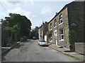
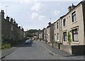
Lower Newlands, Rastrick
This street and houses were built between 1850 and 1895. Although near to a group of fields called Newlands, the street was built in a field called Little Royd Close.
Image: © Humphrey Bolton
Taken: 15 Aug 2008
0.02 miles
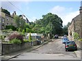
2
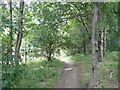
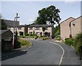
Footpath off Stratton Park, Rastrick
This is the top end of the path up from Lords Lane Image, which originally just led to Round Wood and adjacent fields, but now connects to the Stratton Park and Stratton Road housing estates.
Image: © Humphrey Bolton
Taken: 1 Sep 2008
0.02 miles
3
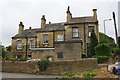
Nos. 31, 33 and 35 Huddersfield Road
There is an OS benchmark Image on the side of the right hand house at its front corner
Image: © Roger Templeman
Taken: 24 Jul 2018
0.04 miles
4
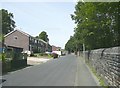
Lord's Lane, Rastrick
This road seems to have been made when the railway was constructed alongside c.1840. By 1859 the only development along the road was Crossley Street.
Image: © Humphrey Bolton
Taken: 15 Aug 2008
0.04 miles
5
Crossley Street, Rastrick
The houses on the left are on the 1850 OS map, but with only a very narrow street. The wide street and the houses on the right were shown on the 1907 map but not the one of c.1895.
Image: © Humphrey Bolton
Taken: 15 Aug 2008
0.04 miles
6
Newlands Close, Rastrick
When the houses on the west side of Crossley Street were built around 1900, a gap was left to give access to a triangular field behind. This was duly developed as Newlands Close in the late 20C (Newlands was the name of the field, or rather of a series of fields on the east side of Huddersfield Road).
Image: © Humphrey Bolton
Taken: 15 Aug 2008
0.04 miles
7
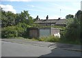
Lockup garages, Crossley Street, Rastrick
The old maps suggest that there were houses on this site, but they had been pulled down by 1907, and it seems strange that the site has not yet been redeveloped.
Image: © Humphrey Bolton
Taken: 15 Aug 2008
0.04 miles
8
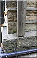
Benchmark on #35 Huddersfield Road
Ordnance Survey cut mark benchmark described on the Bench Mark Database at https://www.bench-marks.org.uk/bm41900
Image: © Roger Templeman
Taken: 24 Jul 2018
0.05 miles
10
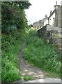
Old path off Lord's Lane, Rastrick
This used to branch off from Birds Royd Lane, before the railway was constructed and Lord's Lane was made. It led to some fields and a wood. Later it was the access to Fieldhead, the white house at the top, but presumably it has an alternative access now. It is a public footpath to Stratton Road.
Image: © Humphrey Bolton
Taken: 15 Aug 2008
0.07 miles