IMAGES TAKEN NEAR TO
Slade Lane, BRIGHOUSE, HD6 3PL
Introduction
This page details the photographs taken nearby to Slade Lane, HD6 3PL by members of the Geograph project.
The Geograph project started in 2005 with the aim of publishing, organising and preserving representative images for every square kilometre of Great Britain, Ireland and the Isle of Man.

There are currently over 7.5m images from over14,400 individuals and you can help contribute to the project by visiting https://www.geograph.org.uk
Image Map
Images are licensed for reuse under creativecommons.org/licenses/by-sa/2.0
Notes
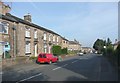
- Clicking on the map will re-center to the selected point.
- The higher the marker number, the further away the image location is from the centre of the postcode.
Image Listing (241 Images Found)
Images are licensed for reuse under creativecommons.org/licenses/by-sa/2.0
Image
Details
Distance
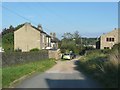
1
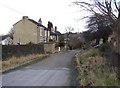
Lower Fold, Rastrick, Yorkshire
This is off Slade Lane, near to its junction with Crowtrees Lane. There was a group of houses here in 1850, and a farm, further down near the blue car, that was still there in the 1950s. Beyond the houses the lane becomes a footpath to Carr Green Lane, although much of it has been obliterated by a housing estate and the path diverted onto the estate road.
Image: © Humphrey Bolton
Taken: 17 Feb 2006
0.01 miles
2
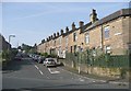
Garlick Street, Rastrick
This was built later than I expected. The street was laid out between the 1895 and 1910 maps, but the houses not built until after 1910. The field name was Green Piece.
Image: © Humphrey Bolton
Taken: 20 Sep 2008
0.01 miles
3
Houses in Slade Lane, Rastrick
These are modern houses on the east side of Slade Lane, north of Lower Fold.
Image: © Humphrey Bolton
Taken: 20 Sep 2008
0.01 miles
4
Houses in Slade Lane, Rastrick
These are houses on the east side of Slade Lane, south of Lower Fold. The nearest was built all on its own between 1910 and 1935, and the two pairs of semis between 1935 and 1940. These dates all approximate. The field was Plack Royd, if I have read the township map correctly.
Image: © Humphrey Bolton
Taken: 20 Sep 2008
0.01 miles
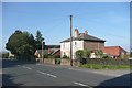
5
Lower Fold, off Slade Lane, Rastrick
See also Image The main difference seems to be that some trees on the right have been cut down.
Image: © Humphrey Bolton
Taken: 20 Sep 2008
0.01 miles
6
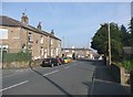
Slade Lane, Rastrick
This is the western side of the lower end of the road, with 19C houses built on Green Piece at about the same time as those along Garlick Street.
Image: © Humphrey Bolton
Taken: 20 Sep 2008
0.01 miles
7
Houses in Slade Lane, Rastrick
These are on the western side just above Garlick Street. When the late 19C terrace houses were built there was already an old building on the site of the modern house.
Image: © Humphrey Bolton
Taken: 20 Sep 2008
0.01 miles
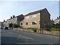
8
Houses in Slade Lane, Rastrick
These are the terrace houses to the north of Greenhead Lane, built on the edge of a field called Croft. The two to the right of the creeper existed in 1850; the others are later.
Image: © Humphrey Bolton
Taken: 20 Sep 2008
0.01 miles
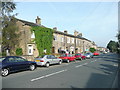
9
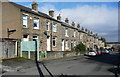
Houses in Slade Lane, Rastrick
A row of three houses that look superficially similar, but the details of the lintels and door head of the left houses are different, and the stonework has a join. The two houses on the right look to have been built together, but the window and door positions are different. Also there is a blocked-up arched entrance above the back of the red van that might have been a through passage (unfortunately this detail has disappeared in the image during the reduction to 640 pixels).
Image: © Humphrey Bolton
Taken: 20 Sep 2008
0.01 miles
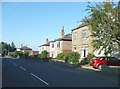
10
Garlick Street, Rastrick
This street and its houses was built in the early 20C. It is not on the 1907 edition of the 1:2500 map, but is on the 1918 revision.
Image: © Humphrey Bolton
Taken: 28 Feb 2017
0.04 miles