IMAGES TAKEN NEAR TO
Broomhill Crescent, ALEXANDRIA, G83 9PW
Introduction
This page details the photographs taken nearby to Broomhill Crescent, G83 9PW by members of the Geograph project.
The Geograph project started in 2005 with the aim of publishing, organising and preserving representative images for every square kilometre of Great Britain, Ireland and the Isle of Man.

There are currently over 7.5m images from over14,400 individuals and you can help contribute to the project by visiting https://www.geograph.org.uk
Image Map
Images are licensed for reuse under creativecommons.org/licenses/by-sa/2.0
Notes
- Clicking on the map will re-center to the selected point.
- The higher the marker number, the further away the image location is from the centre of the postcode.
Image Listing (49 Images Found)
Images are licensed for reuse under creativecommons.org/licenses/by-sa/2.0
Image
Details
Distance
1
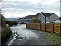
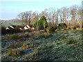
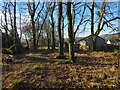
The former site of Highdykes Farm
The site in question is, roughly, the location of the buildings slightly left of centre, that is, the ones behind the left-hand end of the fence. The farm was shown here on the first-edition OS map (surveyed in 1860) and on later maps throughout much of the twentieth century.
The viewpoint is from the point where a track first enters a built-up area, which is part of Broomhill Crescent (Image), in the Beechwood and Wheatcroft Estate.
For a view in the opposite direction from the same point on the track, see Image Followed in that direction, it leads to the current location of Image; see that picture for further comments.
Image: © Lairich Rig
Taken: 5 Jan 2021
0.06 miles
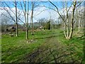
2
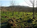
Footpath around Beechwood Estate
The path leads right around the outer edge of Beechwood Estate, although here, on the northern side, it is separated from the estate by an old dry-stone wall and by a strip of woodland that is older and much denser than that crossed by the path itself.
Image: © Lairich Rig
Taken: 4 Dec 2009
0.09 miles
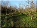
3
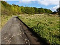
Path through the woods
The path leads around the outer edge of the Beechwood and Wheatcroft Estates. Not far ahead, it meets a Image
Image: © Lairich Rig
Taken: 10 Apr 2014
0.09 miles
4
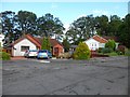
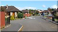
Houses on Broomhill Crescent, Bonhill
Next to the road to Highdykes.
Image: © Stephen Sweeney
Taken: 4 Sep 2012
0.10 miles
5
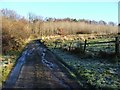
View to start of track
This is a view along a footpath (not very distinct at this point) that leads around the outside of Beechwood Estate (some of the houses in that estate are visible in the middle distance); the footpath begins at the gate that can be seen in the right-hand side of the photo. A farm track also begins at that point; see Image, where the same gate is visible.
The background hill on the left is Overton Muir, with Image just visible in front of it.
For a closer view of the houses visible in the present photograph, see Image
Image: © Lairich Rig
Taken: 4 Dec 2009
0.12 miles
6
Broomhill Crescent
This is part of an area of housing called Beechwood and Wheatcroft Estates (built 1980s–90s).
Image: © Lairich Rig
Taken: 15 Sep 2011
0.12 miles
7
Track to Highdykes Farm
The view is from near the start of the core path that is described in the end-note. Compare Image, taken from a little further back.
Image: © Lairich Rig
Taken: 5 Oct 2012
0.12 miles
8
Footpath around Beechwood Estate
The photo was taken from the same point as Image, but is a view in the opposite direction.
In the distance, the far side of the steep-sided valley of the Murroch Burn is visible, crossing the background from left to right. Behind that, and filling only half of the width of the image, are the Lang Craigs, at a distance of 3 km: Image
Image: © Lairich Rig
Taken: 4 Dec 2009
0.13 miles
9
Path to Murroch Crescent
As the map shows, the Red Burn flows parallel to and not far to the left (southeast) of the path.
Image: © Lairich Rig
Taken: 24 Dec 2020
0.13 miles
10
Track to Highdykes Farm
The core path referred to in the end-note begins at this point, at the northern edge of Beechwood Estate (the area of housing indicated on the map); the route follows the track, which is a continuation of a road within the estate (Image).
For view from further along this route, see Image, Image and Image, and, in the opposite direction, Image
Just beyond the gate, a less distinct footpath leads off to the right (Image), heading parallel to the edge of the housing estate, but separated from it by a strip of woodland.
Image: © Lairich Rig
Taken: 4 Dec 2009
0.13 miles