IMAGES TAKEN NEAR TO
Pappert, ALEXANDRIA, G83 9LF
Introduction
This page details the photographs taken nearby to Pappert, G83 9LF by members of the Geograph project.
The Geograph project started in 2005 with the aim of publishing, organising and preserving representative images for every square kilometre of Great Britain, Ireland and the Isle of Man.

There are currently over 7.5m images from over14,400 individuals and you can help contribute to the project by visiting https://www.geograph.org.uk
Image Map
Images are licensed for reuse under creativecommons.org/licenses/by-sa/2.0
Notes
- Clicking on the map will re-center to the selected point.
- The higher the marker number, the further away the image location is from the centre of the postcode.
Image Listing (36 Images Found)
Images are licensed for reuse under creativecommons.org/licenses/by-sa/2.0
Image
Details
Distance
2
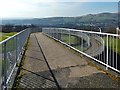
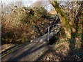
Footbridge over road
This is the footbridge that is marked as "FB" on the 1:25000 OS map. It leads from Pappert (near side) to Ladyton (for a view back towards this footbridge from the section of path visible on the left, see Image).
The houses in the middle distance, on the right, are in Ladyton, but those in the background are in Renton and Alexandria. Carman Hill (Image) and adjacent muirs are in the background, on the right.
Image: © Lairich Rig
Taken: 24 Feb 2014
0.11 miles
3
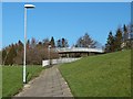
Path and footbridge
The path is marked on the 1:25000 OS map, as is the footbridge (as "FB"), which crosses above a road, and which leads from Ladyton (on this side) to Pappert. There is sometimes the temptation to bypass a winding footbridge by crossing the road directly, but not here: the houses on the Pappert side sit above a steep high bank.
For a view in the opposite direction from on top of the footbridge, see Image In that photograph, the section of path from which the present picture was taken can be seen on the left, with the same lamp posts visible.
Image: © Lairich Rig
Taken: 24 Feb 2014
0.11 miles
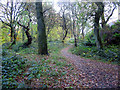
4
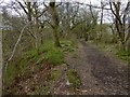
Path with remains of a wall
On the right (to the north of the path), but hidden by the trees, is the dry-stone wall that forms the boundary of the adjacent field. To the left, the ground falls away steeply to the course of the Pappert Burn.
However, the present picture was framed to include the remains of a stone-built wall. Its low, inconspicuous traces are centrally placed in the picture, receding directly from the photographer's position. They are apparent as a few stones visible through the vegetation.
Remains of this wall can be seen alongside much of the length of this path, though they are generally likely to pass unnoticed. The old wall runs parallel to the field boundary, maintaining a more or less constant distance from it.
The wall to the right is a field boundary, but the much-decayed wall to the left might, at first, appear to have served little purpose: the slope there is not one that presents a danger to walkers now, nor would it have done so in the past.
The presence of the wall is probably a reminder that this was once part of a drove road that led from Bonhill, up over Pappert Hill, over the Hill of Standing Stones, across the Common Ford, and so to the great cattle trysts.
The space between the field boundary and the slope leading to the burn is wide for a walker, but less so for a cattle drove, and a wall to prevent livestock from wandering down onto the slope would probably have been a welcome feature.
The present-day stone wall that forms a field boundary on the other side of the path was presumably also present then, and the cattle would thus have been driven uphill between the two stone walls.
The present-day path meanders more than the old drove road did; in places, they separate and rejoin.
Image: © Lairich Rig
Taken: 29 Apr 2016
0.12 miles
5
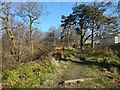
Woodland path
To the left (north) of the path, the ground slopes down steeply to the course of the Pappert Burn. On the right are the houses in Pappert. Further uphill, at the top of the housing estate, the path emerges into the open: Image / Image
There is another path running parallel to this one on the other side of the burn: Image The intervening glen of the burn would make it difficult to cross from one path to another at this point, and the other path is best joined either at its downhill end (Image), or much further uphill (near a Image), where the course of the burn is very shallow.
Image: © Lairich Rig
Taken: 24 Feb 2014
0.12 miles
7
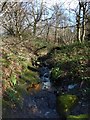
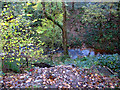
The Pappert Burn
(Or Bonhill Burn.) This is a view upstream from a Image
Image: © Lairich Rig
Taken: 7 Feb 2014
0.13 miles
8
Footbridge over the Pappert Burn
The footbridge is not far from the markers that indicate the start of this path: Image For the burn, as seen from the footbridge, see Image
Image: © Lairich Rig
Taken: 7 Feb 2014
0.14 miles
9
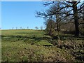
Edge of a field
The picture was taken near the southern end of a Image To the right, on the other side of the field boundary, is Pappert Well Community Woodland.
Image: © Lairich Rig
Taken: 24 Feb 2014
0.14 miles