Path with remains of a wall
Introduction
The photograph on this page of Path with remains of a wall by Lairich Rig as part of the Geograph project.
The Geograph project started in 2005 with the aim of publishing, organising and preserving representative images for every square kilometre of Great Britain, Ireland and the Isle of Man.

There are currently over 7.5m images from over 14,400 individuals and you can help contribute to the project by visiting https://www.geograph.org.uk
Path with remains of a wall
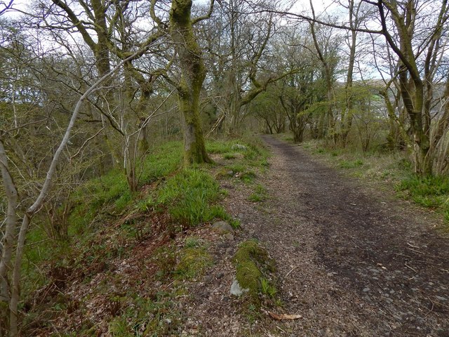
Image: © Lairich Rig Taken: 29 Apr 2016
On the right (to the north of the path), but hidden by the trees, is the dry-stone wall that forms the boundary of the adjacent field. To the left, the ground falls away steeply to the course of the Pappert Burn. However, the present picture was framed to include the remains of a stone-built wall. Its low, inconspicuous traces are centrally placed in the picture, receding directly from the photographer's position. They are apparent as a few stones visible through the vegetation. Remains of this wall can be seen alongside much of the length of this path, though they are generally likely to pass unnoticed. The old wall runs parallel to the field boundary, maintaining a more or less constant distance from it. The wall to the right is a field boundary, but the much-decayed wall to the left might, at first, appear to have served little purpose: the slope there is not one that presents a danger to walkers now, nor would it have done so in the past. The presence of the wall is probably a reminder that this was once part of a drove road that led from Bonhill, up over Pappert Hill, over the Hill of Standing Stones, across the Common Ford, and so to the great cattle trysts. The space between the field boundary and the slope leading to the burn is wide for a walker, but less so for a cattle drove, and a wall to prevent livestock from wandering down onto the slope would probably have been a welcome feature. The present-day stone wall that forms a field boundary on the other side of the path was presumably also present then, and the cattle would thus have been driven uphill between the two stone walls. The present-day path meanders more than the old drove road did; in places, they separate and rejoin.
Images are licensed for reuse under creativecommons.org/licenses/by-sa/2.0
Image Location
Latitude
55.983448
Longitude
-4.561022