IMAGES TAKEN NEAR TO
Cardross Road, DUMBARTON, G82 5DG
Introduction
This page details the photographs taken nearby to Cardross Road, G82 5DG by members of the Geograph project.
The Geograph project started in 2005 with the aim of publishing, organising and preserving representative images for every square kilometre of Great Britain, Ireland and the Isle of Man.

There are currently over 7.5m images from over14,400 individuals and you can help contribute to the project by visiting https://www.geograph.org.uk
Image Map
Images are licensed for reuse under creativecommons.org/licenses/by-sa/2.0
Notes
- Clicking on the map will re-center to the selected point.
- The higher the marker number, the further away the image location is from the centre of the postcode.
Image Listing (75 Images Found)
Images are licensed for reuse under creativecommons.org/licenses/by-sa/2.0
Image
Details
Distance
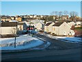
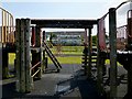
1
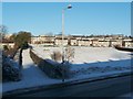
Path to Dalmoak
Cardross Road is visible in the foreground. On its far side, on the left, the route that is confined between two hedges is the first part of a path to Dalmoak.
That path is signposted (on the lamp post) as "Path to Dalmoak via Castlehill ¾ mile".
The former site of Hawthornhill Farm is visible in this picture: to the left of the lamp post, and to the right of the hedge-lined path, is a large drain cover; directly behind that is a green embankment with less snow cover than its surroundings. The buildings of Hawthornhill stood on the flat area at the top of that embankment, centred on Image: Image
Image: © Lairich Rig
Taken: 24 Dec 2010
0.04 miles
2
Path from Hawthornhill Road
This path was once a road leading from Hawthornhill Farm; the farm, now long gone, was at the other end, behind the photographer: Image Ahead, the path meets Cardross Road; see Image, a view back from the other side of that road. The houses in the background are in Westcliff.
Compare Image, similar to the present picture, but looking in the other direction along the path.
Image: © Lairich Rig
Taken: 9 Apr 2019
0.04 miles
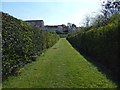
3
Path to Hawthornhill Road
This photograph is a view from the start of the path that can be seen, between two hedges, in Image In the present view, only the nearer part of the path (the first 30 metres or so) is in the same grid square as the photographer. This short path leads from Cardross Road to Hawthornhill Road, but it is part of a longer route, a core path, from Hawthornhill to Dalmoak.
This hedge-lined path was originally a track leading from Cardross Road to Hawthornhill Farm. The farm itself is long gone, but the buildings were just to the right of the far end of this path, on the top of the grassy slope that can be seen there; see Image for the site itself.
Ahead, just to the right of the far end of the path, is Image As that photo makes clear, there are a few narrow gaps between the buildings of Perray Avenue; these divide the row of houses into four sections.
Without familiarity with the area, it is not at all clear where to go after ascending this path between the two hedges. However, the easiest way to continue along the core path to Dalmoak is to go through the narrow gap between the first and second sections (reckoning from the leftmost/western end) of Perray Avenue, emerging at the point shown in Image
Image: © Lairich Rig
Taken: 24 Mar 2011
0.05 miles
4
Drain cover at Hawthornhill
For context, see Image and Image, in both of which the drain cover is visible. The houses in the background are in Westcliff. Behind the hedge on the right is a path (shown at the second of the links just given), formerly a road to the now gone Hawthornhill Farm: Image
Image: © Lairich Rig
Taken: 7 Jun 2020
0.06 miles
5
Hawthorn Avenue
Cardross Road runs across the image from left to right in the foreground. The road branching off from it is Hawthorn Avenue.
The elevated viewpoint for this photograph was the top of a slope in front of neighbouring Westcliff.
Image: © Lairich Rig
Taken: 24 Dec 2010
0.07 miles
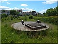
6
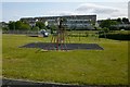
Play area at Hawthornhill
See Image, taken on the same occasion, for comments on the area. The houses in the background are in Westcliff.
Image: © Lairich Rig
Taken: 26 Jun 2013
0.07 miles
7
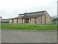
Dalreoch United Free Church of Scotland
On Hawthornhill Road.
Image: © Stephen Sweeney
Taken: 23 Mar 2011
0.07 miles
8
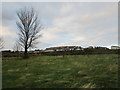
Housing on the edge of Dumbarton
Rather exposed on a hilltop but with good views across the Clyde.
Image: © Jonathan Thacker
Taken: 2 Nov 2017
0.08 miles
9
Play area at Hawthornhill
Being here with family gave an opportunity to show the area; see Image for a less obstructed view.
The buildings in the background are in Westcliff. Image is nearby. See Image for the surroundings.
Image: © Lairich Rig
Taken: 26 Jun 2013
0.08 miles
10
Dalreoch United Free Church of Scotland
Another contributor's earlier (2011) picture: Image
Image: © Lairich Rig
Taken: 7 Jun 2020
0.08 miles