IMAGES TAKEN NEAR TO
DUMBARTON, G82 3PY
Introduction
This page details the photographs taken nearby to G82 3PY by members of the Geograph project.
The Geograph project started in 2005 with the aim of publishing, organising and preserving representative images for every square kilometre of Great Britain, Ireland and the Isle of Man.

There are currently over 7.5m images from over14,400 individuals and you can help contribute to the project by visiting https://www.geograph.org.uk
Image Map
Images are licensed for reuse under creativecommons.org/licenses/by-sa/2.0
Notes
- Clicking on the map will re-center to the selected point.
- The higher the marker number, the further away the image location is from the centre of the postcode.
Image Listing (50 Images Found)
Images are licensed for reuse under creativecommons.org/licenses/by-sa/2.0
Image
Details
Distance
1

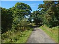
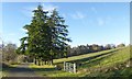
Garshake Farm
The photo was taken from the footpath to Overtoun House. About 100 metres NE of the point where the photo was taken, a track leading to the farm branches off from the footpath.
Image: © Lairich Rig
Taken: 22 Oct 2008
0.00 miles
2
Avenue from Overtoun House
The avenue is depicted on the map. Not far ahead, it turns left (see Image for a view from beyond that corner). At that point, a private road branches off, leading to Image
Image: © Lairich Rig
Taken: 24 Aug 2016
0.11 miles
3
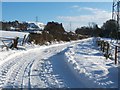
Track to Garshake Farm
This picture was taken at a point 270 metres further along the track that was shown in Image
From the corner from which the present photograph was taken, Image is 280 metres ahead. I was not heading to the farm, so I turned back at this point.
The distant background, on the left, shows part of the Kilpatrick Hills escarpment; compare Image
Image: © Lairich Rig
Taken: 2 Dec 2010
0.11 miles
4
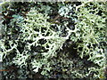
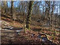
A lichen - Evernia prunastri
A common name for this species is "Oak Moss", although it is not a moss, nor is it confined to Oak trees. The specimen in this photograph was growing on the bark of a tree that stands beside a footpath leading to Overtoun House.
This is a fairly common species on trees, and it is quite tolerant of air pollution. Although it looks rather similar to Ramalina farinacea, the branches of Evernia prunastri have a paler underside, a feature that is visible in this photograph (see also Image). Another similar species is Pseudevernia furfuracea: Image
In some countries, E. prunastri and P. furfuracea are economically important species: "The perfume industry uses lichens in large quantities, chiefly oak moss Evernia prunastri (L.) Ach. and tree moss Pseudevernia furfuracea (L.) Zopf, thousands of tons of which are collected from trees in the forests of France, Yugoslavia, and Morocco" [Jack R. Laundon, in "Lichens" (Shire Natural History)].
Other diverse uses for this species, as listed by Frank S. Dobson in "Lichens - An Illustrated Guide to the British and Irish Species", include: a flavouring for bread in the Middle East; wadding in shotguns; and a nest-building material that is favoured by long-tailed tits. The same work notes that "the usnic acid it contains can be used to produce an antibiotic but it has also been known to produce an allergy in woodcutters".
Image: © Lairich Rig
Taken: 22 Feb 2008
0.14 miles
5
Access track for Garshake Reservoir
The track is a continuation of one that passes nearby Garshake Farm. For the reservoir itself, see Image / Image and (distant views) Image / Image The present view is from near the northern corner of the reservoir's enclosure.
Image: © Lairich Rig
Taken: 15 Jan 2016
0.16 miles
6
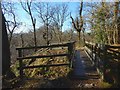
Overtoun House Nature Trail
The footbridge leads over a deep channel cut by a small tributary of the Overtoun Burn.
Image: © Lairich Rig
Taken: 1 Feb 2019
0.16 miles
7
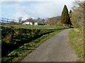
Driveway from Overtoun House
The road shown here is a late-nineteenth-century driveway leading from Image In the right background is the woodland edge which the OS map shows leads northwards from the road.
See Image for a view in the opposite direction.
Image: © Lairich Rig
Taken: 22 Nov 2013
0.17 miles
8
Overtoun House Nature Trail
The view is from further along the path shown in Image, and it includes one of the colour-coded marker posts that were added in recent years (see the end-note).
Image: © Lairich Rig
Taken: 1 Feb 2019
0.17 miles
9
Avenue to Overtoun House
This road was built as an avenue that led uphill from Image (the building on the right in that photograph was a lodge), and which crossed Overtoun Bridge – http://www.geograph.org.uk/snippet/5180 – to provide access to Image The avenue was part of the same building programme as the bridge, and it was opened on the 7th of June, 1895; see Image Compare Image
Later housing developments make it harder to recognise the lower half of the original avenue as such, but see Image and Image for parts of it. Above Campbell Avenue, which is at the top of the area of housing, the avenue is easier to discern: see Image and the present photograph.
The building on the left is Image
Image: © Lairich Rig
Taken: 27 Apr 2012
0.17 miles
10
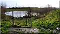
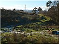
Garshake Reservoir
For further details, see another contributor's earlier photograph: Image For two distant views, one taken when the reservoir was still in use, and the other 21 years later, see Image and Image
The present photograph was taken from the northern corner of the fence that surrounds the disused reservoir. As a check on view direction, a small double bump at the centre of the skyline is Dumbowie Hill, its more pointed SE summit behind and just to the left of its more rounded NW one: http://www.geograph.org.uk/snippet/266
In one of his "Streetwise" features in the Lennox Herald newspaper (issue of 28th July 2006), Billy Scobie records that a German sea-mine was discovered embedded in the silt in this reservoir in 1982.
Image: © Lairich Rig
Taken: 23 Dec 2011
0.18 miles