IMAGES TAKEN NEAR TO
Dullatur Road, GLASGOW, G68 0FZ
Introduction
This page details the photographs taken nearby to Dullatur Road, G68 0FZ by members of the Geograph project.
The Geograph project started in 2005 with the aim of publishing, organising and preserving representative images for every square kilometre of Great Britain, Ireland and the Isle of Man.

There are currently over 7.5m images from over14,400 individuals and you can help contribute to the project by visiting https://www.geograph.org.uk
Image Map
Images are licensed for reuse under creativecommons.org/licenses/by-sa/2.0
Notes
- Clicking on the map will re-center to the selected point.
- The higher the marker number, the further away the image location is from the centre of the postcode.
Image Listing (17 Images Found)
Images are licensed for reuse under creativecommons.org/licenses/by-sa/2.0
Image
Details
Distance
1
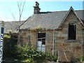
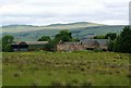
Derelict Westerwood Farmhouse
Once a beautiful building. The farm and its land were bought over and converted into Westerwood Golf Course. Farmhouse and other farm buildings have been used as the course maintenance depot. Lack of maintenance on fabric of building and wanton vandalism over past years have left it in this sorry state. The accommodation has been supplemented with couple of portakabins now for security reasons.
Around 150 years ago the farmhouse was originally built on the site of a Roman fort on the Antonine Wall. Remnants of the wall still exist a short distance away. Presume they had vandals in olden times too - that's why probably the wall was dismantled.
Image: © Derek Ferris
Taken: 21 Jun 2007
0.01 miles
2
![Westerwood Farm (ruin) [2]](https://s2.geograph.org.uk/geophotos/02/81/98/2819878_2b7f5f44_120x120.jpg)
Westerwood Farm (ruin) [2]
View of the farmhouse from the Antonine Wall - which in this stretch looks very much like a farm track.
Image: © Robert Murray
Taken: 15 Feb 2012
0.01 miles
3
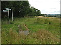
Signpost at Westerwood Farm
A new signpost giving directions and distances to
Castlecary, The Village and Croy.
It's on the course of The Antonine Wall.
Indeed that is the reason for the signpost being here.
See www.geograph.org.uk/photo/2559345 for a closer look.
Image: © Texas Radio and The Big Beat
Taken: 18 Aug 2011
0.01 miles
4
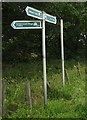
Signpost at Westerwood Farm
A new signpost which has recently sprouted
on the path of The Antonine Wall.
See also www.geograph.org.uk/photo/2559328
Image: © Texas Radio and The Big Beat
Taken: 18 Aug 2011
0.01 miles
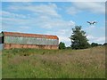
5
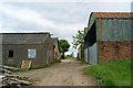
Track Through Westerwood Farm
Track through the derelict farm.
The main farm buildings are on the left with the barn and byre on the right.
More recently the farm was a youth centre. This is evident from some of the
signage and also things like the toilet and shower blocks.
Image: © Texas Radio and The Big Beat
Taken: 12 Jun 2010
0.02 miles
6
Westerwood Farm (derelict)
Image: © Texas Radio and The Big Beat
Taken: 12 Jun 2010
0.02 miles
7
Westerwood
An abandoned farm, its field now used by the golf course.
Image: © Mick Garratt
Taken: 20 Aug 2012
0.02 miles
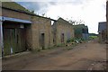
8
Westerwood Farm Buildings
Behind the large tree lies the third fairway, but don't worry the plane will carry on just a tad further to land at airport.
Image: © Derek Ferris
Taken: 21 Jun 2007
0.03 miles
9
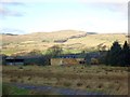
Westerwood Farm (ruin)
Sited almost on top of a Roman fort it has only fallen into disuse in fairly recent times as its land was taken over by a golf club.
Image: © Robert Murray
Taken: 15 Feb 2012
0.03 miles
10
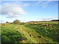
The Roman Frontier
Or where the Tyranny of Rome was halted.
Image: © Robert Murray
Taken: 15 Feb 2012
0.08 miles