IMAGES TAKEN NEAR TO
Hendry Avenue, DENNY, FK6 5ET
Introduction
This page details the photographs taken nearby to Hendry Avenue, FK6 5ET by members of the Geograph project.
The Geograph project started in 2005 with the aim of publishing, organising and preserving representative images for every square kilometre of Great Britain, Ireland and the Isle of Man.

There are currently over 7.5m images from over14,400 individuals and you can help contribute to the project by visiting https://www.geograph.org.uk
Image Map
Images are licensed for reuse under creativecommons.org/licenses/by-sa/2.0
Notes
- Clicking on the map will re-center to the selected point.
- The higher the marker number, the further away the image location is from the centre of the postcode.
Image Listing (12 Images Found)
Images are licensed for reuse under creativecommons.org/licenses/by-sa/2.0
Image
Details
Distance
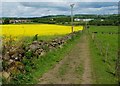
1
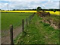
Footpath to Chacefield Wood
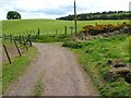
From a three-way Image, one branch leads uphill, heading south towards Chacefield Wood; for the view back along that part of the route, see Image, which was taken at the point where that ascending footpath turns sharply to the west.
The present photograph was taken from the same sharp turning, and shows the footpath leading westwards for a distance of 140 metres, after which it turns left to resume its southward course; see Image for a view along that section of the route.
Image: © Lairich Rig
Taken: 24 May 2010
0.04 miles
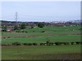
2
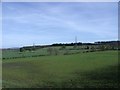
Towards Chacefield Wood
The fields of Mydub.
Image: © Robert Murray
Taken: 17 Apr 2011
0.05 miles
3
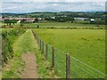
Footpath from Chacefield Wood
The path leads straight ahead, then turns sharply right (east); see Image for a view westwards along that section of the route. It then resumes its northward course, as shown in Image
See the last-cited link, above, for the large building visible in the background, on the right.
Image: © Lairich Rig
Taken: 14 Jun 2010
0.07 miles
4
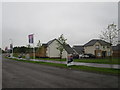
New housing at Wypers Place
Looking from Denny Eastern Access Road.
Image: © Oast House Archive
Taken: 4 Aug 2019
0.13 miles
5
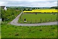
Fields of Mydub
Mydub farm to the left of centre with Cuthelton farm to the right. The enormous petro-chemical plant at Grangemouth can be glimpsed on the horizon.
Image: © Robert Murray
Taken: 17 Apr 2011
0.13 miles
6
Footpath from Chacefield Wood
The photograph was taken at the point where an eastward-heading footpath turns sharply towards the north. The photograph is a view downhill along that northward section, which leads to a three-way Image
The large building in the background, beyond the far end of this section of the footpath, is the new Denny High School, the construction of which was completed a little over a year before this photograph was taken.
For another photograph taken from the same point, see Image
Image: © Lairich Rig
Taken: 24 May 2010
0.14 miles
7
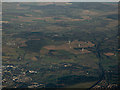
Denny from the air
Unfortunately, Denny is synonomyous with electricity pylons, many of which can be seen in the left half of this photo. The M876 motorway can be seen on the right as can Todhill wind farm.
Image: © Thomas Nugent
Taken: 4 Dec 2016
0.15 miles
8
Track to Mydub Farm
This photograph was taken from a three-way Image The track can be followed past Mydub Farm, and leads back to the main road; see Image
The houses visible in the background are in Freeneuk Lane, and in adjacent parts of the same scheme.
Image: © Lairich Rig
Taken: 24 May 2010
0.18 miles
9
Footpath junction
Following Image for 240 metres beyond Mydub Farm leads to the three-way junction shown here. The left branch is a Image, while that on the right is a footpath that leads to Chacefield Wood; for a view back along that footpath, see Image
For a view back along the section of path in the foreground, see Image
Image: © Lairich Rig
Taken: 24 May 2010
0.19 miles
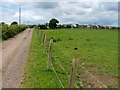
10
Track to Mydub Farm
The photograph was taken from beside the main road (Glasgow Road). The route is signposted as follows: "Private Road to Mydub Farm / No motor vehicles unless authorised / Others users welcome, please keep to the path and keep your dog under close control", accompanied by the symbols for cyclists, pedestrians, and horse riders.
After passing Mydub Farm, the track leads to a three-way junction, where one branch leads to Cuthelton Farm and another to Chacefield Wood: Image
The houses on the left are in Demoreham Avenue.
Image: © Lairich Rig
Taken: 24 May 2010
0.21 miles