IMAGES TAKEN NEAR TO
Melbourne Road, COVENTRY, CV5 6JL
Introduction
This page details the photographs taken nearby to Melbourne Road, CV5 6JL by members of the Geograph project.
The Geograph project started in 2005 with the aim of publishing, organising and preserving representative images for every square kilometre of Great Britain, Ireland and the Isle of Man.

There are currently over 7.5m images from over14,400 individuals and you can help contribute to the project by visiting https://www.geograph.org.uk
Image Map
Images are licensed for reuse under creativecommons.org/licenses/by-sa/2.0
Notes
- Clicking on the map will re-center to the selected point.
- The higher the marker number, the further away the image location is from the centre of the postcode.
Image Listing (281 Images Found)
Images are licensed for reuse under creativecommons.org/licenses/by-sa/2.0
Image
Details
Distance
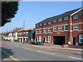
1
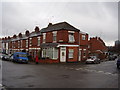
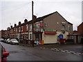
Another one bites the dust
Possibly the local Post Office now a private dwelling.
Melbourne and Sovereign Roads. Spon End.
Image: © Anthony Vosper
Taken: 14 Feb 2015
0.04 miles
2
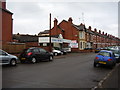
Noble Motors, Shackleton Road
A small back street family-owned garage and car sales establishment.
Image: © Anthony Vosper
Taken: 14 Feb 2015
0.05 miles
3
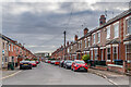
Kirby Road
Early 20th Century terraced housing off Hearsall Lane, marked out but without development on the 1914 1:2,500 map.
Image: © Ian Capper
Taken: 24 Sep 2021
0.06 miles
4
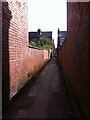
Alleyway off Farman Road, Earlsdon
One of Earlsdon's many distinctive back alleys, this one runs between Farman Road and Kingston Road, where there is a slight break in the line by the school. It then continues to Broomfield Road. Perhaps a field path ran here before the building of the houses in the late 19th century.
Image: © A J Paxton
Taken: 9 Oct 2021
0.07 miles
5
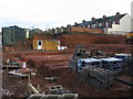
The gap, Hearsall Lane
For many years this was vacant land hidden by advertising hoardings. Then it was a partially dug bit of land next to hoardings. Now the hoardings are gone, it's a bigger hole and new housing is under construction. The backs of houses in Latham Road are visible in the background. As you can see, it has rained recently and clay doesn't drain well.
Image: © E Gammie
Taken: 24 Dec 2011
0.09 miles
6
Hanging on
A lot of the local corner shops have closed down and become private dwellings.
This one has bucked the trend and carries on as an Off Licence.
Image: © Anthony Vosper
Taken: 14 Feb 2015
0.09 miles
7
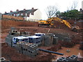
The gap, Hearsall Lane
Construction work under way on new housing in Hearsall Lane on a plot that has been vacant for many years. The building with plastic sheeting covering its end wall stands on Hearsall Lane and the houses in the background are in Latham Road.
Image: © E Gammie
Taken: 24 Dec 2011
0.09 miles
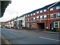
8
Sovereign Road, Spon End
Late Victorian houses in the heart of the city.
Spon End was once the centre of the city's watch making industry.
Image: © Anthony Vosper
Taken: 14 Feb 2015
0.09 miles
9
Hearsall Lane
Sandwiched between early 20th century housing on the left and Wells Terrace (constructed 2011/12) on the right is a building which was formerly an industrial photographer's premises but was standing empty when the photo was taken.
This is the approximate location of a pound shown on a 1912 Ordnance Survey 1:2,500 map of the area. Stray animals would be held in the pound until claimed by the owners.
Image: © E Gammie
Taken: 12 May 2016
0.09 miles
10
Hearsall Lane
Most of the housing on Hearsall Lane was constructed in the early years of the 20th century. In contrast, the buildings in the foreground were constructed almost 100 years later. The nearer building, Wells Terrace, was built in a long-standing gap in 2011/12 and the neighbouring grey and white building constructed on the site of a former industrial photographer's building seen here in 2016: Image
Image: © E Gammie
Taken: 9 Jan 2023
0.10 miles