IMAGES TAKEN NEAR TO
Kirby Road, COVENTRY, CV5 6HL
Introduction
This page details the photographs taken nearby to Kirby Road, CV5 6HL by members of the Geograph project.
The Geograph project started in 2005 with the aim of publishing, organising and preserving representative images for every square kilometre of Great Britain, Ireland and the Isle of Man.

There are currently over 7.5m images from over14,400 individuals and you can help contribute to the project by visiting https://www.geograph.org.uk
Image Map
Images are licensed for reuse under creativecommons.org/licenses/by-sa/2.0
Notes
- Clicking on the map will re-center to the selected point.
- The higher the marker number, the further away the image location is from the centre of the postcode.
Image Listing (233 Images Found)
Images are licensed for reuse under creativecommons.org/licenses/by-sa/2.0
Image
Details
Distance
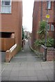
1
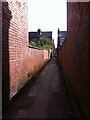
Alleyway off Farman Road, Earlsdon
One of Earlsdon's many distinctive back alleys, this one runs between Farman Road and Kingston Road, where there is a slight break in the line by the school. It then continues to Broomfield Road. Perhaps a field path ran here before the building of the houses in the late 19th century.
Image: © A J Paxton
Taken: 9 Oct 2021
0.01 miles
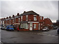
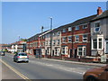
2
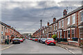
Kirby Road
Early 20th Century terraced housing off Hearsall Lane, marked out but without development on the 1914 1:2,500 map.
Image: © Ian Capper
Taken: 24 Sep 2021
0.01 miles
3
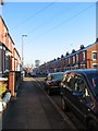
Sovereign Road, Earlsdon
Early 20th century red brick terraces. Ground floor window bays in contrast to flat frontages in nearby Kingston Road ( http://www.geograph.org.uk/photo/2189942 ). The tower block in the distance is the Ramada hotel in the Butts (SP3278).
Image: © E Gammie
Taken: 7 Dec 2010
0.05 miles
4
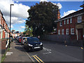
East on Kingston Road, Earlsdon, Coventry
The side entrance to the school has 'Infants' over the door. Behind the camera is Centaur Road.
Image: © Robin Stott
Taken: 8 Sep 2016
0.07 miles
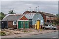
5
Another one bites the dust
Possibly the local Post Office now a private dwelling.
Melbourne and Sovereign Roads. Spon End.
Image: © Anthony Vosper
Taken: 14 Feb 2015
0.07 miles
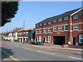
6
Hearsall Lane
Small businesses in Hearsall Lane
Image: © Ian Capper
Taken: 24 Sep 2021
0.07 miles
7
Alley from Craven Street to Hearsall Lane
Image: © Keith Williams
Taken: 28 Mar 2009
0.08 miles
8
Hearsall Lane
Sandwiched between early 20th century housing on the left and Wells Terrace (constructed 2011/12) on the right is a building which was formerly an industrial photographer's premises but was standing empty when the photo was taken.
This is the approximate location of a pound shown on a 1912 Ordnance Survey 1:2,500 map of the area. Stray animals would be held in the pound until claimed by the owners.
Image: © E Gammie
Taken: 12 May 2016
0.08 miles
9
Wells Terrace, Hearsall Lane
Housing constructed in 2011/12 between terraced houses dating from the early 20th century.
Image: © E Gammie
Taken: 12 May 2016
0.08 miles
10
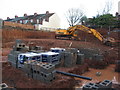
The gap, Hearsall Lane
For many years this was vacant land hidden by advertising hoardings. Then it was a partially dug bit of land next to hoardings. Now the hoardings are gone, it's a bigger hole and new housing is under construction. The backs of houses in Latham Road are visible in the background. As you can see, it has rained recently and clay doesn't drain well.
Image: © E Gammie
Taken: 24 Dec 2011
0.08 miles