IMAGES TAKEN NEAR TO
Earl Street, COVENTRY, CV1 5RR
Introduction
This page details the photographs taken nearby to Earl Street, CV1 5RR by members of the Geograph project.
The Geograph project started in 2005 with the aim of publishing, organising and preserving representative images for every square kilometre of Great Britain, Ireland and the Isle of Man.

There are currently over 7.5m images from over14,400 individuals and you can help contribute to the project by visiting https://www.geograph.org.uk
Image Map
Images are licensed for reuse under creativecommons.org/licenses/by-sa/2.0
Notes
- Clicking on the map will re-center to the selected point.
- The higher the marker number, the further away the image location is from the centre of the postcode.
Image Listing (1690 Images Found)
Images are licensed for reuse under creativecommons.org/licenses/by-sa/2.0
Image
Details
Distance
1
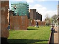
Raised lawn by the Herbert
A raised lawn beside the extended Herbert Art Gallery and Museum is edged with rolled steel and divided by vertical steel slabs. Laser-cut inscriptions on each slab record the occupants of houses in Bayley Lane down the centuries. Many end '1940 Destroyed by the Blitz'. Seen from the other side in Image and Image
Image: © Robin Stott
Taken: 16 Apr 2010
0.00 miles
2

The west side of the Herbert
A raised lawn beside the extended Herbert Art Gallery and Museum is edged with rolled steel and divided by vertical steel slabs. Laser-cut inscriptions on each slab record the occupants of houses in Bayley Lane down the centuries. Many end '1940 Destroyed by the Blitz' Image and Image A view of the lawn is Image
Image: © Robin Stott
Taken: 16 Apr 2010
0.00 miles
3
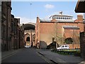
St Mary Street
The view is from Earl Street through the ruins of the old cathedral to the great canopy over the south end of its modern successor. The east side of the Council House is in shadow on the left. The space on the right is behind Brown's café-bar, whose arched roof just pushes into the picture.
Image: © Robin Stott
Taken: 16 Apr 2010
0.00 miles
4
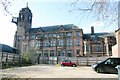
East fa?ade of The Council House, Earl Street, Coventry
Grade II Listed civic building of 1913-17 by Edward Garret and H W Simister of Birmingham. Since the medieval period, the civic administration of Coventry had been housed in St Mary's Guildhall. A new building was proposed in 1891 by Alderman James Marriott, but it took over 20 years to find a location. The building would involve the demolition of the existing police station, all properties on the west side of St Mary Street, the block of property extending from the corner of St. Mary Street along Earl Street as far as F. J. Thomas's shop, the Gas Offices, Town Clerk's Office and the premises of Messrs, Dewes, Seymour and Wilks in Hay Lane. The foundation stone was laid on 12 June 1913 by the Mayor, William Fitzthomas Wyley but construction was delayed when WWI broke out because so many men enlisted that there were not enough builders available. Although finished in 1917 it did not officially open until 11th June 1920, in a ceremony presided over by HRH The Duke of York, Prince Albert, later to become King George VI. The Coventry Herald called it 'slightly vulgar' and the Coventry Graphic thought it was 'gaudy'. The Council House lost its windows in the 1940 bombing but the building itself escaped major damage. In September 2017 the council moved some 1,500 staff to its new 13-storey tower block at One Friargate. The council retained The Council House as home for the city’s councillors, debates and the council’s democratic services.
Image: © Jo and Steve Turner
Taken: 23 Feb 2023
0.01 miles
5
Council House, St Mary Street / Earl Street junction
There is an OS benchmark Image on the right hand end of the jut right of the silver waste bin
Image: © Roger Templeman
Taken: 3 Jan 2015
0.01 miles
6
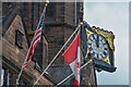
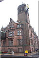
Coventry : The Council House
Looking towards the clock and flags of the USA and Canada.
Image: © Lewis Clarke
Taken: 25 Sep 2021
0.01 miles
7
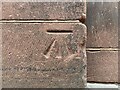
Benchmark, Coventry, Council House
Detail of an Ordnance Survey cut benchmark on the south face of the Council House, near the south east corner of the building facing Earl Street. The benchmark marks a height of 87.441m above Ordnance Datum Newlyn last levelled and verified in 1958 (location photograph Image).
Image: © Adrian Taylor
Taken: 25 Aug 2022
0.01 miles
8
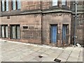
Building detail, Coventry Council House
Detail of part of the south face of Coventry Council House near the south east corner facing onto Earl Street.
There is an Ordnance Survey cut benchmark near the bottom of the wall (photograph Image).
There is a square stop valve cover in the pavement and nearby is a small rectangular hydrant cover with the inscription ‘Coventry Waterworks’.
Image: © Adrian Taylor
Taken: 25 Aug 2022
0.01 miles
9
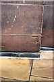
Benchmark on Council Offices
Ordnance Survey cut mark benchmark described on the Bench Mark Database at http://www.bench-marks.org.uk/bm63353
Image: © Roger Templeman
Taken: 3 Jan 2015
0.01 miles
10
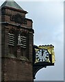
Coventry Council House clock
Projecting from the bell tower with a fine gilded angel.
Image: © Alan Murray-Rust
Taken: 23 Sep 2021
0.01 miles