IMAGES TAKEN NEAR TO
West Street, COVENTRY, CV1 5EE
Introduction
This page details the photographs taken nearby to West Street, CV1 5EE by members of the Geograph project.
The Geograph project started in 2005 with the aim of publishing, organising and preserving representative images for every square kilometre of Great Britain, Ireland and the Isle of Man.

There are currently over 7.5m images from over14,400 individuals and you can help contribute to the project by visiting https://www.geograph.org.uk
Image Map
Images are licensed for reuse under creativecommons.org/licenses/by-sa/2.0
Notes
- Clicking on the map will re-center to the selected point.
- The higher the marker number, the further away the image location is from the centre of the postcode.
Image Listing (134 Images Found)
Images are licensed for reuse under creativecommons.org/licenses/by-sa/2.0
Image
Details
Distance
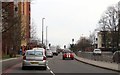
1
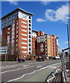
Multi-storey student accommodation in Coventry
Viewed across the A4600 Sky Blue Way. The nameboards show Liberty Living Trinity Point.
Image: © Jaggery
Taken: 18 Apr 2015
0.01 miles
2
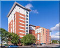
Sky Blue Point
Student accommodation overlooking Sky Blue Way, built in around 2005. Originally called Trinity Point, it was later renamed Liberty Point and then its current name, Sly Blue Point.
Image: © Ian Capper
Taken: 24 Sep 2021
0.02 miles
4
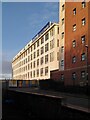
Self-storage warehouse, West Street, Hillfields
The building to the right is a block of student flats.
Image: © A J Paxton
Taken: 6 Jan 2024
0.02 miles
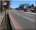
6
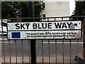
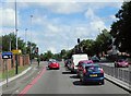
Road sign, Sky Blue Way, Coventry
Sky Blue Way is a stretch of dual carriageway connecting the Coventry Ring Road to the A444 Jimmy Hill Way. It was built in the 1980s to bypass the historic Far Gosford Street (and clearly the European Community chipped in). It was named after the colour of Coventry City Football Club, winners of the FA Cup in 1987, who at that time still played at the Highfield Road stadium nearby (Jimmy Hill had been the manager who had brought them to first division prominence some years earlier).
Image: © A J Paxton
Taken: 22 Jul 2021
0.03 miles
7
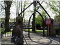
Arch, All Saint's Square
The arch marks the entrance to a church that was demolished during the building of Sky Blue Way.
Image: © Keith Williams
Taken: 23 Apr 2015
0.04 miles
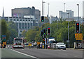
9
Red route, Sky Blue Way, Coventry
This part of the A4600 Sky Blue Way is a Red Route - no stopping at any time.
Image: © Jaggery
Taken: 18 Apr 2015
0.05 miles
10
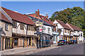
Far Gosford Street
Restored buildings of various ages in Far Gosford Street, one of the historic routes into the city, now bypassed by Sky Blue Way. On the left is nos 32-33 and further along are nos 38 and nos 39-40, all 16th Century or earlier and grade II listed - see www.historicengland.org.uk/listing/the-list/list-entry/1342928, www.historicengland.org.uk/listing/the-list/list-entry/1115599 and www.historicengland.org.uk/listing/the-list/list-entry/1076644 respectively. In the centre is the former Beer Engine pub, now converted to residential use.
Image: © Ian Capper
Taken: 24 Sep 2021
0.05 miles