IMAGES TAKEN NEAR TO
Armathwaite, CARLISLE, CA4 9PY
Introduction
This page details the photographs taken nearby to CA4 9PY by members of the Geograph project.
The Geograph project started in 2005 with the aim of publishing, organising and preserving representative images for every square kilometre of Great Britain, Ireland and the Isle of Man.

There are currently over 7.5m images from over14,400 individuals and you can help contribute to the project by visiting https://www.geograph.org.uk
Image Map
Images are licensed for reuse under creativecommons.org/licenses/by-sa/2.0
Notes
- Clicking on the map will re-center to the selected point.
- The higher the marker number, the further away the image location is from the centre of the postcode.
Image Listing (95 Images Found)
Images are licensed for reuse under creativecommons.org/licenses/by-sa/2.0
Image
Details
Distance
2
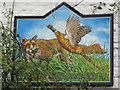
Sign for The Fox and Pheasant Inn, near Armathwaite
See Image
Image: © Mike Quinn
Taken: 14 Oct 2011
0.02 miles
3
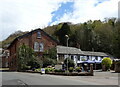
The Fox and Pheasant Inn, near Armathwaite
Image: © Mike Quinn
Taken: 14 Oct 2011
0.02 miles
4
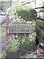
Ainstable Low Qr Township boundary stone
Near Armathwaite Place. For a close-up, see Image
Image: © Christine Johnstone
Taken: 22 Oct 2019
0.02 miles
5
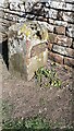
Ainstable Low Quarter boundary stone
Image gives additional information.
The stone has Milestone Society National ID: CU_AINS01pb
Image: © Roger Templeman
Taken: 17 Apr 2021
0.02 miles
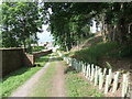
7
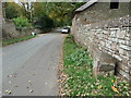
Road leading to Armathwaite Bridge
There is a boundary stone Image on the verge on the far side of the road
Image: © Roger Templeman
Taken: 17 Apr 2021
0.04 miles
8
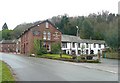
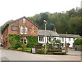
The Fox and Pheasant, Ainstable
Here three roads converge on their way to a bridge over the River Eden; a good place for an inn, and this one has spread itself through two quite different buildings. Although this group of buildings is in Ainstable Civil Parish, it is near Armathwaite, and this is its postal address.
Image: © Humphrey Bolton
Taken: 27 Jan 2009
0.05 miles
9
Boundary stone, Ainstable
This marks the boundary of Ainstable Low Quarter, which was presumably the division of Ainstable township. In 1866 township divisions were abolished, and are not shown on the First Edition six-inch map for this area, which was published in 1867.
Image: © Humphrey Bolton
Taken: 27 Jan 2009
0.05 miles
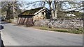
10
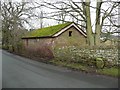
Farm building and boundary stone, Ainstable
The farm building looks like a small barn, in the style of estate architecture. On the side next to the road there is a round-headed window with an iron grille in the opening. The boundary stone is shown in Image
Image: © Humphrey Bolton
Taken: 27 Jan 2009
0.05 miles