IMAGES TAKEN NEAR TO
Ham Link, BRISTOL, BS40 7AW
Introduction
This page details the photographs taken nearby to Ham Link, BS40 7AW by members of the Geograph project.
The Geograph project started in 2005 with the aim of publishing, organising and preserving representative images for every square kilometre of Great Britain, Ireland and the Isle of Man.

There are currently over 7.5m images from over14,400 individuals and you can help contribute to the project by visiting https://www.geograph.org.uk
Image Map
Images are licensed for reuse under creativecommons.org/licenses/by-sa/2.0
Notes
- Clicking on the map will re-center to the selected point.
- The higher the marker number, the further away the image location is from the centre of the postcode.
Image Listing (26 Images Found)
Images are licensed for reuse under creativecommons.org/licenses/by-sa/2.0
Image
Details
Distance
1
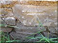
Ordnance Survey Cut Mark
This OS cut mark can be found on the shed west side of the track. It marks a point 94.439m above mean sea level.
Image: © Adrian Dust
Taken: 30 May 2023
0.03 miles
2
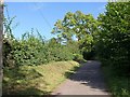
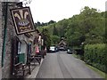
Ham Link
The lane crosses the southwest corner of the square as it climbs along the edge of the Mendips between Burrington and Rickford.
Image: © Derek Harper
Taken: 14 Aug 2011
0.18 miles
3
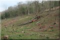
Mendip north Forest
As Ecology generally disapproves of 1960s Forestry Commission work, Hydrology, Water Resources and prevention of waste pollution in water catchments perhaps now Eco system should offer answers on how to use land, retain soils, stop floods, provide water, keep the community, utilize timber ? I have been in Hydrology, Forest hydrology, soils design geology for 43 years since UCW student and I would like to spend the next years able to enjoy work to good purpose and some success.
Image: © Michael Dennis Stagg
Taken: 16 Apr 2009
0.20 miles
4
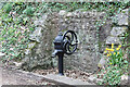
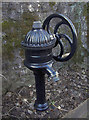
Water hydrant, The Batch, Rickford
This apparent pump has the wording 'open/shut' on the wheel which implies that it controls a valve and hence water under pressure making it a hydrant. Below the level of the Rickford Rising it could be fed from the millpond or from the early piped water supply to the village. The outlet fitting suggests it was used for attaching a hose rather than a village water supply.
Image: © Jo and Steve Turner
Taken: 9 Mar 2022
0.21 miles
5
Rickford pump
The village used to take its water from this standpipe; it appears to be a modern version but there seems to have been a pipe here from the late nineteenth century. Even though the village has a number of Bristol Waterworks buildings and plant right on their doorsteps, the villagers were often to be found taking water directly from the brook here, right up until the 1940s.
Image: © Neil Owen
Taken: 16 Feb 2016
0.21 miles
6
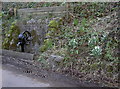
Village pump
A standpipe that used to provide clean water for the village of Rickford. It appears to be a modern interpretation and possibly replaces an earlier version. See Image] for a closer look.
A pump at the other end of the village was used for the steam locomotives that ran along the Mendips before Beeching.
Image: © Neil Owen
Taken: 16 Feb 2016
0.21 miles
8
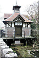
Gauge House, The Batch, Rickford
Grade II Listed late 19th century sluice-house. It was built in 1895 by the Bristol Waterworks Company, beneath which is the sluice controlling the flow of water into the brook. It also controls an underground pipe to Blagdon Lake. Rickford Pond that flows into the brook under the house is fed from Rickford Rising on the opposite side of the road at the south end of the pond that also fed a leat to a flour mill and later a paper mill. The flour mill appears to have been destroyed by fire.
Image: © Jo and Steve Turner
Taken: 9 Mar 2022
0.22 miles
9
Plume of Feathers, Rickford
Snapped using my work iPhone one day during a delivery to the building next door.
Image: © John Winder
Taken: 22 May 2015
0.22 miles
10
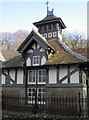
Gauge House
This interesting little building is part of Bristol Waterworks. It rests over the Rickford Spring and acts as a regulating weir to control the water flowing down the valley and extracted by pipeline to the Blagdon works. From there the water goes into the supply system for Bristol.
The house was built in 1895 and has been described thus:
"Late C19. Wooden raft supported by cast iron stanchions over brook. House of rockfaced coursed red sandstone with green sandstone dressings on a limestone plinth. Timber frame outer skin on brick with roughcast infill and plain tile roof. Swiss chalet style. Square on plan with a pyramidal roof and open apex turret with weathervane. Window and door openings to each face which develop into gabled dormers; plank doors with fine ironwork hinges. Retaining wall to roadside of rockfaced squared sandstone with ashlar coping and piers and wrought iron railings."
It is perhaps more notable for having an unusual architectural style for such a functional utility. Just up the lane is the former church, which is much the same style. As the latter was built as part of the Wills tobacco estate, it is likely they were of similar origin.
Image: © Neil Owen
Taken: 16 Feb 2016
0.22 miles