IMAGES TAKEN NEAR TO
Thornbury Drive, WESTON-SUPER-MARE, BS23 4YH
Introduction
This page details the photographs taken nearby to Thornbury Drive, BS23 4YH by members of the Geograph project.
The Geograph project started in 2005 with the aim of publishing, organising and preserving representative images for every square kilometre of Great Britain, Ireland and the Isle of Man.

There are currently over 7.5m images from over14,400 individuals and you can help contribute to the project by visiting https://www.geograph.org.uk
Image Map (Loading...)


Getting Data...Please wait
Leaflet Map data © OpenStreetMap
Images are licensed for reuse under creativecommons.org/licenses/by-sa/2.0
Notes
- Clicking on the map will re-center to the selected point.
- The higher the marker number, the further away the image location is from the centre of the postcode.
Image Listing (165 Images Found)
Images are licensed for reuse under creativecommons.org/licenses/by-sa/2.0
Image
Details
Distance
1
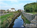
Stream at Uphill
I could not find a name for the stream on the OS map - please enlighten me if you know.
Image: © Ruth Sharville
Taken: 4 Sep 2010
0.04 miles
2

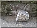
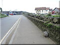
Marker Stone
North side of road against wall of stream.
Image: © Adrian Dust
Taken: 31 Jul 2023
0.05 miles
4
?Western Challenger? at Uphill ? 1978
Near the southern terminus of Weston's open-top bus route. The bus is a Bristol Lodekka FLF, new in 1964 and converted to open-top for sea front service in 1976 following an accident with a low bridge in Bristol. The fleet of open-top buses was painted in various liveries which represented the colours of the various tramway systems that had operated in towns served by the Bristol company. "Western Challenger" represents the former Bristol Tramways and carries a picture of Concorde which was built at Filton in Bristol.
This is one of a series of views featuring buses in the 60s, 70s, and 80s. http://www.geograph.org.uk/search.php?i=137652761
Image: © Alan Murray-Rust
Taken: 4 Aug 1978
0.06 miles
5
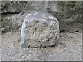
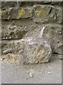
Marker stone on Uphill Way
One of two still visible, despite the ever-rising modern ground level. The stones do not appear to be parish boundary markers, and are described in the Heritage Gateway as 'Sea wall works boundary stones' - probably post-Mediaeval in date. See Image] for another close by.
Image: © Neil Owen
Taken: 25 Apr 2023
0.06 miles
6
Marker Stone
North side of road against wall of stream.
Image: © Adrian Dust
Taken: 31 Jul 2023
0.06 miles
7
Swallowed by the pavement
Not swallowed by the water - which would have more than likely happened over the years gone by. A boundary (?) stone on the Great Rhyne Image], a partner to another: Image
Image: © Neil Owen
Taken: 8 Aug 2013
0.07 miles
8
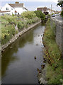
Uphill Great Rhyne
Just before it goes under the bridge and into the sluice gate - Image Also see Image] for some ducks that live on the water, or above it.
Image: © Neil Owen
Taken: 8 Aug 2013
0.07 miles
9
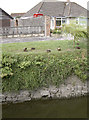
High and drying
Some ducks are happily laid around in the warm afternoon sun, quite some height above the rhyne. See Image
Image: © Neil Owen
Taken: 8 Aug 2013
0.07 miles
10
Along Uphill Way
The road carries the rhyne alongside but also features some stones set into the wall. They are recorded as 'Sea wall works boundary stone' and are post-mediaeval in date. See https://www.geograph.org.uk/photo/7521747 for a look.
Image: © Neil Owen
Taken: 25 Apr 2023
0.07 miles