IMAGES TAKEN NEAR TO
BS15 5SN
Introduction
This page details the photographs taken nearby to BS15 5SN by members of the Geograph project.
The Geograph project started in 2005 with the aim of publishing, organising and preserving representative images for every square kilometre of Great Britain, Ireland and the Isle of Man.

There are currently over 7.5m images from over14,400 individuals and you can help contribute to the project by visiting https://www.geograph.org.uk
Image Map
Images are licensed for reuse under creativecommons.org/licenses/by-sa/2.0
Notes
- Clicking on the map will re-center to the selected point.
- The higher the marker number, the further away the image location is from the centre of the postcode.
Image Listing (19 Images Found)
Images are licensed for reuse under creativecommons.org/licenses/by-sa/2.0
Image
Details
Distance
1
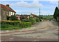
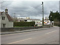
2008 : Top of the village, Wick
This was the old A420 before realignment. There was a nasty bend 1km toward Chippenham and a worse one here. A short cut-off road runs between the garage and Pool Farm.
Image: © Maurice Pullin
Taken: 11 Sep 2008
0.11 miles
2
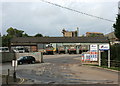
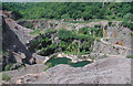
2008 : Wick Quarry
Quarrying is not only about ripping stone out of the ground. See http://www.golden-valley.info/index.htm for a very interesting website, may inspire you to a visit.
Image: © Maurice Pullin
Taken: 11 Sep 2008
0.12 miles
3
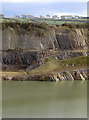
Layer upon layer until the water
Wick quarry reveals its many sediments and strata.
Image: © Neil Owen
Taken: 2 Feb 2018
0.13 miles
4
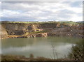
The money below our feet
Wick has been associated with limestone quarrying for many years. In the nineteenth century there was a number of smaller pits and workings but the largest of today's is comfortably bigger still. Cemex are the operators of the quarry and have permitted the founding of the reserve in the early 2000s.
Image: © Neil Owen
Taken: 2 Feb 2018
0.14 miles
5
Wick Quarry
Off Old London Road, operated by Cemex http://www.cemexlocations.co.uk/cemex/product/concrete/county/Avon/town/Bristol/plant/CEMEX%20UK%20Building%20Products%20Ltd%20-%20Wick.htm
Image: © Mike Faherty
Taken: 7 Apr 2010
0.15 miles
6
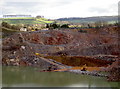
A reddish hue
Wick quarry extracts the limestone, but the distinct red colour indicates that this area is rich in ochre. There was a large ochre works just along the River Boyd not so long ago but the seam was depleted by the 1970s. However, the rock still retains the colour.
Image: © Neil Owen
Taken: 2 Feb 2018
0.16 miles
7
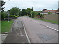
Wick: London Road (old section)
This road, which eventually becomes Bury Lane leading to Doynton at the junction in the distance, was once the main London Road. It has now been bypassed with the realigned A420 to the south.
Image: © Nigel Cox
Taken: 25 Jun 2011
0.16 miles
10
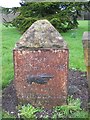
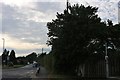
Old Boundary Marker by the A420, London Road, Wick
Turnpike Terminus Marker by the UC road, in parish of Wick and Abson (South Gloucestershire District), London Road, Wick, opposite junction with Bath Road, on green.
Inscription reads:-
THE
BATH ROADS
{HAND->}
TO THE
GUILDHALL
BATH
(5¾)
Carved bench mark on West face.
Grade II listed.
List Entry Number: 1216416 https://historicengland.org.uk/listing/the-list/list-entry/1216416
Surveyed
Milestone Society National ID: GL_BAWK05t
Image: © Milestone Society
Taken: Unknown
0.20 miles